Chapter 27
ZONING:
ARTICLES VII - XV
|
Art. I to VI. |
|
|
Art. VII. |
Districts, §§ 27-61--27-220. |
|
|
Div. 1. Generally, §§ 27-61--27-70. |
|
|
Div. 2. District A, Agricultural District, §§ 27-71--27-74. |
|
|
Div. 3. District R-R, Rural Residential District, §§ 27-75--27-80. |
|
|
Div. 4. District S-R, Suburban Residential District, §§
27-81--27-90. |
|
|
Div. 5. District R-1, One and Two Family Residential District, §§
27-91--27‑100. |
|
|
Div. 6. District R-2, One to Four Family Residential District,
§§ 27-101--27-110. |
|
|
Div. 7. District R-3, Multiple-family Residential District,
§§ 27-111--27‑120. |
|
|
Div. 8. District R-M, Mobile Home District, §§ 27-121--27-125. |
|
|
Div. 8.5. District R-T, Tiny House District, §§ 27-126--27-130. |
|
|
Div. 9. District R-O, Limited Residential Office District,
§§ 27-131--27‑140. |
|
|
Div. 10. District O-D, Office District, §§ 27-141--27-150. |
|
|
Div. 11. District C-1, Local Business District, §§ 27-151--27-160. |
|
|
Div. 12. District C-2, Central Business District, §§ 27-161--27-170. |
|
|
Div. 13. District C-2A, Special Business District, §§ 27-171--27-180. |
|
|
Div. 14. District C-3, Service Commercial District, §§ 27-181--27-190. |
|
|
Div. 15. District B-P, Business Park District, §§ 27-191 – 27-194 |
|
|
Div. 16. District I-1, Light Industrial District, §§ 27-195--27-200. |
|
|
Div. 17. District I-2, Heavy Industrial District, §§ 27-201--27-220. |
|
|
Div. 18. District I-3, Limited Industrial District, §§ 27-211--27-220. |
|
Art. VIII. |
Special and Overlay Districts, §§ 27-221--27-280. |
|
|
Div. 1. Mixed Use Special
District, §§ 27-221--27-230. |
|
|
Div. 2. Planned Development Overlay District, §§ 27-231--27-240. |
|
|
Div. 3. Flood Plain Overlay District, §§ 27-241--27-260. |
|
|
Div. 4. Airport Overlay District, §§ 27-261--27-280. |
|
|
Div. 5. Wellhead Protection Overlay District, §§
27-271--27-279 |
|
|
Div. 6. North Fork of the Elkhorn River Overlay District, §§
27-280.01--27-280.06 |
| |
Div. 7. Highway Corridor Overlay District, §§
27-280.21--27-280.27 |
| |
|
|
Art. IX. |
Supplemental Regulations, §§ 27-281--27-300. |
|
Art. X. |
Landscaping and Screening, §§
27-301--27-320 |
|
Art. XI. |
Signs, §§ 27-321--27-340. |
|
Art.
XII. |
Off-street Parking and Loading, §§ 27-341 -
27-359. |
|
Art. XIII. |
Regulation of the Siting of Wireless Telecommunicatings Facilities, §§ 27-360--27-400. |
|
Art. XIV. |
Sexually Oriented Businesses, §§ 27-401--27-411. |
| Art. XV. |
Land Use Matrix, § 27-601. |
| |
|
Chapter 27 Articles I to VI
ARTICLE
VII. DISTRICTS
DIVISION
1. GENERALLY
Sec. 27-61. Districts
designated.
For the purposes of regulating and
restricting the use of land and the erection, construction, reconstruction,
alteration, moving or use of buildings, structures or land, all lands within
the corporate limits and within the extraterritorial jurisdiction of the city
are hereby divided into the following districts:
District A
Agricultural District
District
R-R
Rural Residential District
District
S-R
Suburban Residential District
District
R-1
Single-family Residential District
District
R-2
One and Two Family Residential District
District
R-3
Multiple-family Residential District
District
R-M
Mobile Home District
District
R-O
Limited Residential Office District
District
O-D
Office District
District
C-1
Local Business District
District
C-2
Central Business District
District
C-2A
Special Business District
District
C-3
Service Commercial District
District
B-P
Business Park District
District
I-1
Light Industrial District
District
I-2
Heavy Industrial District
District
I-3
Limited Industrial District
Source: Ord. No. 4603, § 1, 9-16-02
Sec. 27-62. Use Matrix
and Use Lists by District.
(1) This chapter includes lists of uses within the district regulations and
a use matrix designated as Sec. 27-401. Generally, these listed uses and
the matrix are considered to be cumulative and together describe all the uses
permitted within the zoning district. In cases where the uses listed in
the district regulations provide more restrictive development controls or
special regulations than the use matrix provides, the listed uses in the
district regulations shall be considered superior.
(2) Uses not listed under the district regulations or in the land use matrix
set forth in Sec. 27-401 of this chapter may be placed in a suitable district
classification by the zoning official after considering the zoning
classification of other similar or related uses.
Source: Ord. No. 4603, § 1, 9-16-02
Secs. 27-63--27-70.
Reserved.
DIVISION
2. DISTRICT A, AGRICULTURAL DISTRICT
Sec.
27-71. Intent - District A.
The Agricultural District (A) is intended to
recognize the use of agricultural land for purposes of farming and other
agricultural practices and to protect the land from premature urbanization.
It is essential that scattered, indiscriminate urban development within areas
best suited for agriculture be precluded and that orderly urban development be
facilitated. This district is designed to maintain complete agricultural uses
within the Norfolk extraterritorial jurisdiction until such time as the natural
growth of the municipality precludes preservation thereof.
Source: Ord. No. 4603, § 1, 9-16-02;
Ord. No. 5521, § 1, 2-20-18;
Sec.
27-72. Permitted uses - District A.
In District A, no building,
structure, land, or premises shall be used, and no building or structure shall
be hereafter erected, constructed, reconstructed, moved, or altered as a
permitted use, except for one or more of the following or as provided for in
Sec. 27-601:
(1) Agriculture, including agricultural accessory
buildings without limit to total floor area.
(2) Single-family residential dwellings.
(3) Manufactured
home dwelling as defined by Sec. 27-2.
(4)
Accessory dwelling units, as per Sec. 27-287 (b).
(5)
Religious assemblies.
(6) Community
buildings, museums, and libraries.
(7)
Philanthropic institutions or other public
institutions.
(8) Publicly
owned parks and playgrounds including public recreation or service buildings
within such parks, public administrative buildings, police and fire stations,
and public utility buildings and structures other than communication towers.
(9)
Schools and private schools.
(10)
Railroad rights-of-way not including railroad yards or
buildings.
(11)
Cemeteries and mortuaries.
(12) Home occupations.
(13) Non-agricultural
accessory buildings less than the smaller of 5% of the total lot area or 3,500
square feet. The accessory building shall not be utilized for any
non-residential use unless said use is a permitted use within the
district.
(14)
Soil extraction for public road purposes when meeting the requirements set forth
in Section 27-293.
Source: Ord. No. 4603, § 1, 9-16-02; Ord.
4679, § 1, 8-18-03; Ord. No. 5444, § 4, 12-19-16; Ord. No. 5521, § 2,
2-20-18; Ord. No. 5799, § 2, 9-6-22;
Sec.
27-73. Conditional uses - District A.
In District A,
the following conditional uses, as well as those provided for in Sec. 27-601,
may be allowed. Any conditional use permit shall include as minimal
conditions those conditions specifically set forth in this section for each
conditional use listed. Additional conditions, stipulations, or
restrictions may also be required as is deemed necessary for the protection of
the public interest.
(1) Non-agricultural accessory buildings with a
combined floor area in excess of the smaller of 5% of the total lot area
or 3,500 square feet. The accessory building shall not be utilized for
any non-residential use unless said use is a permitted use within the district.
(2) Fish hatcheries, apiaries and aviaries.
a.
Minimum lot size: Two (2) acres.
b.
Parking shall be not be closer than fifty (50) feet to any property line and
shall be screened from adjacent properties.
(3) Fur farming for the raising of fur bearing
animals.
a.
Minimum lot size: Two (2) acres.
b.
Parking shall be screened from adjacent properties and shall not be located
closer than fifty (50) feet to any property line.
c.
There shall be no processing of animals or animal pelts on the premises.
d.
No pens shall be located closer than two hundred (200) feet to any
residentially zoned district.
(4) Golf courses and customary accessory uses
including club houses, driving ranges and other similar activities.
a.
No parking shall be allowed within fifty (50) feet of a property line and shall
be screened from adjacent properties.
b.
All principal or accessory structures shall be set back a minimum of one
hundred (100) feet from any property line.
(5) Hospitals, sanitariums, licensed elderly and
handicapped facilities.
a.
Minimum lot size: Two (2) acres.
b.
Parking shall be screened from adjacent properties and shall not be located
closer than fifty (50) feet to any property line.
(6) Keeping of livestock or poultry on less than
ten (10) acres.
a.
Minimum lot size: Three (3) acres.
b.
Livestock or poultry shall be located or kept not less than one hundred (100)
feet from any residentially zoned district and shall not be located closer than
fifty (50) feet from any property line.
(7) Kennels, commercial.
a.
Minimum lot size: Two (2) acres.
b.
Parking shall be screened from adjacent properties and shall not be located
closer than fifty (50) feet to any property line.
c.
Buildings and pens used to breed, raise or keep animals shall be located not
less than two hundred (200) feet from any residentially zoned district and
shall not be located closer than one hundred (100) feet from any property line.
(8) Nurseries, greenhouses and truck gardens.
a.
Minimum lot size: Two (2) acres.
b.
Parking shall be screened from adjacent properties and shall not be located
closer than fifty (50) feet to any property line.
c.
All buildings and structures used to store or maintain equipment or
produce shall be located not closer than one hundred (100) feet to any property
line.
(9)
Private recreation facilities.
a.
Minimum lot size: Two (2) acres.
b.
Parking shall be screened from adjacent properties and shall not be located
closer than fifty (50) feet to any property line.
c.
No building shall be closer than one hundred (100) feet to an adjacent property
line.
d.
Outdoor lighting shall be directed so as not to cast direct light upon adjacent
property.
(10)
Stables or riding tracks.
a.
Buildings or structures used to maintain or house horses shall not be located closer
than one hundred (100) feet to any property line.
b.
Buildings and pens used for care or maintenance of horses shall not be located
closer than two hundred (200) feet from any residentially zoned district.
c.
Maximum number of horses shall be one (1) horse per two (2) acres.
Source: Ord. No. 4099, § 1, 7-17-95; Ord. No.
4238, § 2-3-97; Ord. No. 4603, § 1, 9-16-02; Ord. No. 5145, § 2, 12-20-10;
Ord. No. 5799, § 2, 9-6-22;
Sec. 27-74. Height and
area regulations - District A.
(a) In
District A, unless otherwise specified, the maximum height and minimum lot
requirements shall be as follows:
|
|
Minimum
Lot Area
|
Max
Height
|
Min Front Yard
|
Min Side Yard
|
Min Rear Yard
|
Lot
Width
|
Max. Building Coverage |
Max. Impervious Coverage |
|
Permitted
Uses
|
40
acres
|
35’
See (2) below
|
50’
|
15’
|
50’
|
200’
|
N/A |
N/A |
|
Conditional
Uses
|
40
acres
|
35’
See (2) below
|
50’
|
15’
|
50’
|
200’
|
N/A |
N/A |
|
(1)
An area of 39 acres shall be treated as satisfying the 40 acre requirement.
(2) With a conditional use permit, height may be
increased except that in all instances must comply with airport zoning.
|
(b) Where a lot in separate
ownership as of the effective date of this chapter has less area and/or width
than herein required, this regulation shall not prohibit the erection of a
single-family dwelling.
(c) Minimum first story size
of a dwelling shall be six hundred fifty (650) square feet of living floor
area.
(d) Accessory buildings and
structures shall comply with the requirements of Sec. 27-287.
Source: Ord. No. 4603, § 1, 9-16-02; Ord.
No. 5413, § 1, 7-5-16; Ord. No. 5521, § 3, 2-20-18;
DIVISION
3. DISTRICT R-R, RURAL RESIDENTIAL DISTRICT
Sec. 27-75.
Intent – District R-R
The Rural Residential District (R-R) is intended to
provide for rural residential use of land, accommodating very low and low
density residential environments within one-half of the extraterritorial
jurisdiction boundary. It provides for the transition of
agricultural land to low-density forms of residential development that are
designed to combine aspects of urban living with rural life. The
district’s regulations assure that density is developed consistent with land use
policies of the comprehensive plan regarding rural subdivisions; levels of
infrastructure; and environmentally sensitive development practices. It is
designed for use in areas that are outside of the city’s probable urban
development limit that may be unlikely to receive both city water and sewer
service. In these areas, permanent development of houses using wells or
other private water supplies and septic systems or other self-contained
wastewater systems are allowable.
Source: Ord. No. 4603, § 1, 9-16-02;
Ord. No. 5799, § 3, 9-6-22;
Sec.
27-76. Permitted uses – District R-R
In District R-R, no building,
structure, land, or premises shall be used, and no building or structure shall
be hereafter erected, constructed, reconstructed, moved, or altered as a
permitted use, except for one or more of the following or as provided for in
Sec. 27-601:
(1)
Crop product.
(2)
Single-family residential.
(3) Manufactured home dwellings.
(4)
Accessory dwelling units, as per Sec. 27-287 (b).
(5) Religious
assemblies.
(6)
Community buildings, museums, and libraries.
(7) Philanthropic institutions or other public
institutions.
(8)
Publicly owned parks and playgrounds including public
recreation or service buildings within such parks, public administrative
buildings, police and fire stations, and public utility buildings and
structures.
(9)
Schools and private schools.
(10)
Railroad rights-of-way not including railroad yards or
buildings.
(11)
Cemeteries and mortuaries.
(12) Home occupations.
(13) Non-agricultural
accessory buildings less than the smaller of 5% of the total lot area or 3,000
square feet. The accessory building shall not be utilized for any non-residential
use unless said use is a permitted use within the district.
(14)
Soil extraction for public road purposes when meeting the requirements set forth
in Section 27-293.
Source: Ord. No. 4603, § 1, 9-16-02; Ord.
4679, § 2, 8-18-03; Ord. No. 5444, § 5, 12-19-16; Ord. No. 5799,
§ 3, 9-6-22;
Sec.
27-77. Conditional uses - District R-R
In District R-R,
the following conditional uses, as well as those provided for in Sec. 27-601,
may be allowed. Any conditional use permit shall include as minimal
conditions those conditions specifically set forth in this section for each
conditional use listed. Additional conditions, stipulations, or
restrictions may also be required as is deemed necessary for the protection of
the public interest.
(1) Non-agricultural accessory buildings with a
combined area in excess of the smaller of 5% of the total lot area or 3,000
square feet. The accessory building shall not be utilized for any
non-residential use unless said use is a permitted use within the district.
(2) Fish hatcheries, apiaries and aviaries.
a.
Minimum lot size: Two (2) acres.
b.
Parking shall be not be closer than fifty (50) feet to any property line and
shall be screened from adjacent properties.
(3) Fur farming for the raising of fur bearing
animals.
a. Minimum lot size: Two (2)
acres.
b.
Parking shall be screened from adjacent properties and shall not be located
closer than fifty (50) feet to any property line.
c.
There shall be no processing of animals or animal pelts on the premises.
d.
No pens shall be located closer than two hundred (200) feet to any residentially
zoned district.
(4) Golf courses and customary accessory uses
including club houses, driving ranges and other similar activities.
a.
No parking shall be allowed within fifty (50) feet of a property line and shall
be screened from adjacent properties.
b.
All principal or accessory structures shall be set back a minimum of one
hundred (100) feet from any property line.
(5) Hospitals, sanitariums, licensed elderly and
handicapped facilities.
a.
Parking shall be screened from adjacent properties and shall not be located
closer than fifty (50) feet to any property line.
(6) Animal production
a.
Breeding and raising of small animals and fowl, such as birds, rabbits,
chinchilla, and hamsters is permitted provided that any building housing such
animals shall be at least 50 feet from any property line and 100 feet from any
residentially zoned district.
b.
Any lot of one acre and over may maintain one horse, llama, or other equine
and/or hoofed animal and its immature offspring. Such a lot may have one
additional animal for each additional two acres of lot area. No stable
shall be located closer than 50 feet to any dwelling unit on the site or 100
feet from any residentially zoned district.
(7) Kennels, commercial.
a.
Minimum lot size: Two (2) acres.
b.
Parking shall be screened from adjacent properties and shall not be located
closer than fifty (50) feet to any property line.
c.
Buildings and pens used to breed, raise or keep animals shall be located not
less than two hundred (200) feet from any residentially zoned district and
shall not be located closer than one hundred (100) feet from any property line.
(8) Nurseries, greenhouses and truck gardens.
a.
Minimum lot size: Two (2) acres.
b.
Parking shall be screened from adjacent properties and shall not be located
closer than fifty (50) feet to any property line.
c.
All buildings and structures used to store or maintain equipment or produce
shall be located not closer than one hundred (100) feet to any property line.
(9) Private recreation facilities.
a.
Minimum lot size: Two (2) acres.
b.
Parking shall be screened from adjacent properties and shall not be located
closer than fifty (50) feet to any property line.
c.
No building shall be closer than one hundred (100) feet to an adjacent property
line.
d.
Outdoor lighting shall be directed so as not to cast direct light upon adjacent
property.
(10) Stables or riding tracks.
a.
Buildings or structures used to maintain or house horses shall not be located
closer than one hundred (100) feet to any property line.
b.
Buildings and pens used for care or maintenance of horses shall not be located
closer than two hundred (200) feet from any residentially zoned district.
c. Maximum
number of horses shall be one (1) horse per two (2) acres.
Source: Ord. No. 4603, § 1, 9-16-02;
Ord. No. 5145, § 3, 12-20-10; Ord. No. 5799, § 3,
9-6-22;
Sec. 27-78.
Height and area regulations – District R-R
In District R-R, unless otherwise specified, the maximum height and minimum lot
requirements shall be as follows:
|
|
Site Area per Housing Unit |
Minimum Lot Area |
Max Height |
Min Front Yard |
Min Side Yard |
Min Rear Yard |
Lot Width |
|
Permitted Uses |
1 acre; 3 acres if a septic system or other individual
treatment system is used
|
1 acre; 3 acres if a septic system or other individual
treatment system is used
|
35’
See (1) below |
50’ |
15’ |
50’ |
100’ |
|
Conditional Uses |
|
1 acre |
35’
See (1) below |
50’ |
15’ |
50’ |
100’ |
|
(1) With a conditional use permit, height may be
increased except that in all instances must comply with airport zoning.
|
Source: Ord. No. 4603, § 1, 9-16-02; Ord.
No. 5413, § 2, 7-5-16
Secs. 27-79--27-80. Reserved
DIVISION
4. DISTRICT S-R, SUBURBAN RESIDENTIAL DISTRICT
Sec.
27-81. Intent - District S-R.
The Suburban Residential District (S-R) is intended to
provide for large lot, single-family dwelling development. This district
is intended to provide a generally stable residential area with such supporting
community services as parks, playgrounds, schools and religious assemblies.
Existing S-R district zoning will remain and comply with the below standards,
but no property shall be newly zoned S-R following September 6, 2022.
Source: Ord. No. 4603, § 1, 9-16-02;
Ord. No. 5444, § 6, 12-19-16; Ord. No. 5799, § 4,
9-6-22;
Sec.
27-82. Permitted uses - District S-R.
In District S-R, no building,
structure, land, or premises shall be used, and no building or structure shall
be hereafter erected, constructed, reconstructed, moved, or altered as a
permitted use, except for one or more of the following or as provided for in
Sec. 27-601:
(1)
Single-family residential (detached).
(2) Manufactured home dwellings.
(3)
Accessory dwelling units, as per Sec. 27-287(b).
(4)
Publicly owned and operated community
buildings, public museums, public libraries.
(5)
Publicly owned parks and playgrounds including public recreation or service
buildings within such parks, public administrative buildings, police and fire
stations, and public utility buildings and structures.
(6)
Schools and private schools.
(7)
Railroad rights-of-way, not including buildings or yards.
(8)
Home occupations.
(9) Accessory buildings
with a combined floor area of less than the smaller of 5% of the total lot area
or 2,500 square feet. The accessory building shall not be utilized for any
non-residential use unless said use is a permitted use within the
district.
(10) Soil extraction for public road purposes when meeting the requirements set forth
in Section 27-293.
Source: Ord. No. 4603, § 1, 9-16-02; Ord.
4679, § 3, 8-18-03; Ord. No. 5799, § 4, 9-6-22;
Sec.
27-83. Conditional uses - District S-R.
In District S-R,
the following conditional uses, as well as those provided for in Sec. 27-601,
may be allowed. Any conditional use permit shall include as minimal
conditions those conditions specifically set forth in this section for each
conditional use listed. Additional conditions, stipulations, or restrictions
may also be required as is deemed necessary for the protection of the public
interest.
(1)
Accessory buildings with a combined floor area in excess of the smaller
of 5% of the total lot area or 2,500 square feet. Accessory buildings
shall not be utilized for any non-residential use unless said use is a
permitted use within the district.
(2) Religious
assemblies.
a.
Minimum lot size: 15,000 square feet.
b.
No parking shall be located closer than ten (10) feet to any property
line. Such parking shall be screened from adjacent properties.
(3)
Philanthropic institutions or other semi-public institutions.
a.
Minimum lot size: 15,000 square feet.
b.
No parking shall be located closer than ten (10) feet to any property
line. Such parking shall be screened from adjacent properties.
(4) Golf courses and customary accessory uses including club houses, driving ranges
and other similar activities.
a.
No parking shall be allowed within fifty (50) feet of a property line and shall
be screened from adjacent residential properties.
b.
All principal or accessory structures shall be set back a minimum of one
hundred (100) feet from any property line.
(5) Private stables.
a.
Minimum lot size: Two (2)
acres.
b.
Such uses shall not provide for boarding of horses or commercial related
boarding operations.
c.
There shall not be more than one (1) horse per two (2) acres.
(6) Temporary real estate offices.
a.
Such offices shall be located on property being sold and limited to the period
of sale but not to exceed two (2) years.
b.
Building and setback regulations and lot size requirements shall be the same as
for single-family dwellings.
(7) Utility substations.
Facilities
shall be screened from all adjacent uses.
Source: Ord. No. 4099, § 1, 7-17-95; Ord. No. 4238, §
1, 2-3-97; Ord. No. 4603, § 1, 9-16-02; Ord. No. 5145, § 4, 12-20-10; Ord. No.
5444, § 7, 12-19-16; Ord. No. 5799, § 4, 9-6-22;
Sec.
27-84. Height and Area Regulations - District S-R.
(a) In District S-R, unless otherwise specified, the maximum height and
minimum lot requirements shall be as follows:
|
|
Max Height |
Front Yard |
Side
Yard |
Rear
Yard |
Lot
Width |
Lot
Area |
Max Building Coverage |
|
Permitted
Uses |
35’
See (4) below |
35’ |
10'
See (1) below
for additional
requirements |
See
(2)
below |
80’ |
12,000 sq. ft. |
25% |
|
Conditional
Uses (3) |
35’
See (4) below |
35’ |
10'
See (1) below
for additional
requirements |
See
(2)
below |
80’ |
12,000 sq. ft. |
25% |
|
(1) Buildings
on corner lots shall provide a side yard on the street side of not less than
twenty-five (25) feet; provided, however, this regulation shall not reduce
the buildable width of a corner lot in separate ownership as of the effective
date of this chapter to less than thirty-five (35) feet.
(2) The depth of the rear yard shall be at least twenty
percent (20%) of the depth of the lot, but such depth need not be more than
thirty (30) feet.
(3) Unless modified as a part of a site plan or
conditional use permit.
(4) With a conditional use
permit, height may be increased except that in all instances must comply
with airport zoning.
|
|
|
(b) Where a lot in separate
ownership as of the effective date of this chapter has less area and/or width
than herein required, this regulation shall not prohibit the erection of a
single-family dwelling.
(c) Minimum first story size
of a dwelling shall be six hundred fifty (650) square feet of living floor
area.
(d) Accessory buildings and
structures shall comply with the requirements of Sec. 27-287.
Source: Ord. No.
4603, § 1, 9-16-02; Ord. No. 5413, § 3, 7-5-16
Secs. 27-85--27-90. Reserved.
DIVISION
5. DISTRICT R-1, ONE AND TWO FAMILY RESIDENTIAL DISTRICT
Sec.
27-91. Intent - District R-1.
The One and Two Family Residential
District (R-1) is intended for both developed and developing portions of the
city. This district is typically for single-family residences and
two-family residences that have a similar form and mass to the single-family
residences but does
have a larger list of potential conditional uses which may be appropriate in
some areas of this district.
Source: Ord. No. 4603, § 1, 9-16-02;
Ord. No. 5857, § 1, 11-20-23;
Sec.
27-92. Permitted uses - District R-1.
In District R-1, no building,
structure, land, or premises shall be used, and no building or structure shall
be hereafter erected, constructed, reconstructed, moved, or altered as a
permitted use, except for one or more of the following or as provided for in
Sec. 27-601:
(1)
Single-family residential (detached).
(2)
Single-family residential (attached), up to 2 units.
(3) Duplex
residential.
(4)
Manufactured home dwellings.
(5)
Accessory dwelling units, as per Sec. 27-287(b).
(6)
Religious assemblies.
(7)
Community buildings, public museums and public libraries.
(8)
Publicly owned parks and playgrounds,
including public recreation or service buildings within such parks, public
administrative buildings and police and fire stations.
(9)
Schools and private schools.
(10)
Railroad rights-of-way not including
railroad yards or buildings.
(11) Home occupations.
(12) Accessory buildings
with a combined floor area less than the greater of 8% of the total lot area or
864 square feet per lot or four hundred (400) square feet per dwelling unit,
whichever is greater, provided that the total square footage of all accessory
buildings on a single lot shall not exceed 2,000 square feet. The
accessory building shall not be utilized for any non-residential use unless
said use is a permitted use within the district.
(13) Soil extraction for public road purposes when meeting the requirements set forth
in Section 27-293.
Source: Ord. No. 4603, § 1, 9-16-02; Ord.
4679, § 4, 8-18-03; Ord. No. 5444, § 8, 12-19-16; Ord. No. 5799,
§ 5, 9-6-22; Ord. No. 5857, § 1, 11-20-23;
Sec.
27-93. Conditional uses - District R-1.
In District R-1,
the following conditional uses, as well as those provided for in Sec. 27-601,
may be allowed. Any conditional use permit shall include as minimal
conditions those conditions specifically set forth in this section for each
conditional use listed. Additional conditions, stipulations, or restrictions
may also be required as is deemed necessary for the protection of the public
interest.
(1)
Accessory buildings with a combined floor
area in excess of the greater of 8% of the total lot area or 864 square feet.
The accessory building shall not be utilized for any non-residential use unless
said use is a permitted use within the district.
(2)
Golf courses and customary accessory uses including club houses and driving
ranges; except that miniature golf, driving ranges and other similar activities
operated as a stand-alone business shall not be allowed.
a.
No parking shall be allowed within fifty (50) feet of a property line and shall
be screened from adjacent residential properties.
b.
All principal or accessory structures shall be set back a minimum of one
hundred (100) feet from any property line.
(3) Temporary real estate offices.
a.
Such offices shall be located on property being sold and limited to the period
of sale but not to exceed two (2) years.
b.
Building and setback regulations and lot size requirements shall be the same as
for single-family dwellings.
Source: Ord. No. 4238, § 1, 2-3-97; Ord. No.
4603, § 1, 9-16-02; Ord. No. 5857, § 1, 11-20-23;
Sec. 27-94. Height and
Area Regulations - District R-1.
(a) In District R-1, unless otherwise specified, the maximum height and
minimum lot requirements shall be as follows:
|
|
Max Height |
Front Yard |
Side
Yard |
Rear Yard |
Lot Width |
Site Area
per Unit |
Lot
Area |
Max Building Coverage |
Single-Family Detached
Permitted Uses |
35’
See (5)
below |
15' to house
25’ to garage |
7'
See (1) below
for additional
requirements |
See
(2)
below |
50' |
5,000 sq. ft. |
5,000 sq. ft. |
50% |
Single-Family Attached
(up to 2 units)
Permitted Uses |
35’
See (5)
below |
15' to house
25’ to garage |
7'
See (1) below
for additional
requirements |
See
(2)
below |
25' |
3,000 sq. ft. |
3,000 sq. ft. |
55% |
|
Duplex Permitted Uses |
35’
See (5)
below |
15' to house
25’ to garage |
7'
See (1) below
for additional
requirements |
See
(2)
below |
50' |
3,000 sq. ft. |
6,000 sq. ft. |
55% |
|
Other
Permitted Uses |
35’
See (5)
below |
15' to house
25’ to garage |
7'
See (1) below
for additional
requirements |
See
(2)
below |
50’ |
6,000 sq. ft. |
6,000 sq. ft. |
50% |
|
Conditional
Uses (3) |
35’
See (5)
below |
15' to house
25’ to garage |
7'
See (1) below
for additional
requirements |
See
(2)
below |
50’ |
6,000 sq. ft. |
6,000 sq. ft. |
50% |
|
(1) Buildings on corner
lots shall provide a side yard on the street side of not less than fifteen
(15) feet with garage at
twenty-five (25) feet; provided, however, this regulation shall not reduce
the buildable width of a corner lot in separate ownership as of the effective
date of this chapter to less than thirty-five (35) feet.
(2)
The depth of the rear yard shall be at
least twenty percent (20%) of the depth of the lot, but such depth need not
be more than thirty (30) feet.
(3)
Unless modified as a part of a site
plan or conditional use permit.
(4)
Maximum lot size shall not exceed 1 acre.
(5) With a conditional use
permit, height may be increased except that in all instances must comply
with airport zoning.
|
(b) Where a lot in separate
ownership as of November 20, 2023 has less area and/or width
than herein required, this regulation shall not prohibit the erection of a
single-family dwelling.
(c) Minimum first story size
of a dwelling shall be six hundred fifty (650) square feet of living floor
area.
(d) Accessory buildings and structures shall
comply with the requirements of Sec. 27-287.
(e) Zero lot lines shall be allowed for
single-family detached residential structures. Zero lot line
requirements shall be as follows:
(1) When a zero
lot line is utilized:
a.
The opposite side yard shall be fourteen (14) feet.
b.
There shall be provided a five (5) foot easement on the adjoining lot for
maintenance, repair, and roof drainage.
c.
In no case shall there be less than fourteen (14) feet between buildings.
d.
There shall be no openings in a wall on a zero lot line.
(2) The zero lot
line and easements shall be established on the subdivision plat.
(3)
There shall be a rear yard of at least twenty (20) feet.
(f) A party wall agreement shall be
recorded in the office of the Register of Deeds prior to issuance of a
certificate of occupancy for any attached unit building and when a zero lot
line is utilized for single-family detached. Such agreement shall set
terms for maintenance and upkeep of the entire structure and individual
units including color, materials and access for maintenance and repairs.
(g) The scale, mass and form of the
attached unit buildings shall be compatible, comparable, and designed to be
similar to the single-family residences, so that the buildings are
architecturally harmonious with the surrounding residential area.
Source: Ord. No.
4392, § 1, 2-1-99; Ord. No. 4603, § 1, 9-16-02; Ord. No. 5413, § 4, 7-5-16; Ord.
No. 5857, § 1, 11-20-23;
Secs. 27-95--27-100. Reserved.
DIVISION
6. DISTRICT R-2, ONE TO FOUR FAMILY RESIDENTIAL DISTRICT
Sec.
27-101. Intent - District R-2.
The One to Four Family Residential
District (R-2) is intended as a moderate density, residential district. It
is intended for developing and developed portions of the city and recognizes existing, developed neighborhoods as
well as promoting small lots for affordable housing options. As such it
is essential that the height and area requirements be maintained.
Source: Ord. No. 4603, § 1, 9-16-02;
Ord. No. 5857, § 2, 11-20-23;
Sec.
27-102. Permitted uses - District R-2.
In District R-2, no building,
structure, land, or premises shall be used, and no building or structure shall
be hereafter erected, constructed, reconstructed, moved, or altered as a
permitted use, except for one or more of the following or as provided for in
Sec. 27-601:
(1)
Single-family residential (detached).
(2)
Single-family residential (attached), up to 2 units.
(3) Duplex
residential.
(4)
Townhouse residential, up to 4 units.
(5) Manufactured home dwellings.
(6)
Accessory dwelling units, as per Sec. 27-287(b).
(7)
Religious assemblies.
(8) Community buildings, museums and libraries.
(9)
Publicly owned parks and playgrounds, including
public recreations or service buildings with such parks, public administrative
buildings and police and fire stations.
(10)
Schools and private schools.
(11)
Railroad rights-of-way not including
railroad yards or buildings.
(12)
Home occupations.
(13) Soil extraction for public road purposes when meeting the requirements set forth
in Section 27-293.
Source: Ord. No. 4603, § 1, 9-16-02; Ord.
4679, § 5, 8-18-03; Ord. No. 5444, § 9, 12-19-16; Ord. No. 5799,
§ 6, 9-6-22; Ord. No. 5857, § 2, 11-20-23;
Sec.
27-103. Conditional uses - District R-2.
In District R-2, the following
conditional uses, as well as those provided for in Sec. 27-601, may be
allowed. Any conditional use permit shall include as minimal conditions
those conditions specifically set forth in this section for each conditional
use listed. Additional conditions, stipulations, or restrictions may also
be required as is deemed necessary for the protection of the public interest.
(1)
Golf courses and customary accessory uses including club houses and driving
ranges; except that miniature golf, driving ranges and other similar activities
operated as a stand-alone business shall not be allowed.
a.
No parking shall be allowed within fifty (50) feet of a property line and shall
be screened from adjacent residential properties.
b. All principal or accessory
structures shall be set back a minimum of one hundred (100) feet from any
property line.
(2)
Temporary real estate offices.
a.
Such offices shall be located on property being sold and limited to the period
of sale but not to exceed two (2) years.
b.
Building and setback regulations and lot size requirements shall be the same as
for single-family dwellings.
Source: Ord. No. 4603, § 1, 9-16-02;
Ord. No. 5857, § 2, 11-20-23;
Sec.
27-104. Height and Area Regulations - District R-2.
(a) In District R-2, unless otherwise specified, the maximum height and
minimum lot requirements shall be as follows:
|
|
Max
Height |
Front
Yard |
Side
Yard |
Rear
Yard |
Lot
Width |
Site Area
per Unit |
Min Lot
Area |
Building
Coverage |
Single-Family Detached
Permitted Uses |
35’
See (5)
below |
15' to house
25' to garage |
7’
See (1) below |
See
(2)
below |
40’ |
4,000 sq. ft. |
4,000 sq. ft. |
55% |
Single-Family Detached
(zero lot line) |
35’
See (5)
below |
15' to house
25' to garage |
14’ one side, 0’ opposite side. See (1) below |
See
(2)
below |
40’ |
4,000 sq. ft. |
4,000 sq. ft. |
55% |
|
Single-Family Attached (up to 2 units)
Permitted Uses |
35’
See (5)
below |
15' to house
25' to garage |
7’
See (1) below |
See
(2)
below |
25’ |
3,000 sq. ft. |
3,000 sq. ft. |
60% |
|
Duplex Permitted Uses |
35’
See (5)
below |
15' to house
25' to garage |
7’
See (1) below |
See
(2)
below |
50’
|
3,000 sq. ft. |
6,000 sq. ft. |
60% |
|
Townhouse (3 units up to 4 units) Permitted Uses |
35’
See (5)
below |
15' to house
25' to garage |
7’
See (1) below |
See
(2)
below |
25’ |
3,000 sq. ft. |
3,000 sq. ft. (if have individual lot lines); 9,000 sq. ft. (if no individual
lot lines) |
60% |
|
Conditional Uses (3) |
35’
See (5)
below |
15' to house
25' to garage |
7’
See (1) below |
See
(2)
below |
50’ |
|
5,000 sq. ft. |
60% |
|
(1) Buildings on corner lots shall provide a side yard
on the street side of not less than fifteen (15) feet with garage at twenty-five (25) feet; provided, however,
this regulation shall not reduce the buildable width of a corner lot in
separate ownership as of the effective date of this chapter to less than
thirty-five (35) feet.
(2) The depth of the rear yard shall be at least twenty
percent (20%) of the depth of the lot, but such depth need not be more than
thirty (30) feet. On corner lots, twenty percent (20%) of the shortest
lot dimension may be used as the required rear yard setback.
(3) Unless modified as a part of a site plan or
conditional use permit.
(4) Maximum lot size shall not exceed
1 acre.
(5) With a conditional use
permit, height may be increased except that in all instances must comply
with airport zoning.
|
(b) Where a lot in separate
ownership as of November 20, 2023 has less area and/or width
than herein required, this regulation shall not prohibit the erection of a
single-family dwelling or other permitted use meeting the area requirements.
(c) Minimum first story size
of a dwelling unit shall be six hundred fifty (650) square feet of living floor
area.
(d) Zero lot lines shall be
allowed for single-family detached residential structures. Zero lot line
requirements shall be as follows:
(1)
When a zero lot line is utilized:
a.
The opposite side yard shall be fourteen (14) feet.
b.
There shall be provided a five (5) foot easement on the adjoining lot for
maintenance, repair, and roof drainage.
c.
In no case shall there be less than fourteen (14) feet between buildings.
d.
There shall be no openings in a wall on a zero lot line.
(2)
The zero lot line and easements shall be established on the subdivision plat.
(3)
There shall be a rear yard of at least twenty (20) feet.
(e) A party wall agreement shall be recorded in
the office of the Register of Deeds prior to issuance of a certificate of
occupancy for any attached unit building and when a zero lot line is utilized
for single-family detached. Such agreement shall set terms for maintenance
and upkeep of the entire structure and individual units including color,
materials and access for maintenance and repairs.
(f) Accessory buildings and structures shall
comply with the requirements of Sec. 27-287. The total square footage of
floor area for accessory buildings, including detached garages, shall not
exceed eight hundred sixty-four (864) square feet per lot or four hundred (400)
square feet per dwelling unit, whichever is greater.
(g) The scale, mass and form of the
attached unit buildings shall be compatible, comparable and designed to be
similar to the single-family residences, so that the buildings are
architecturally harmonious with the surrounding residential area.
Source: Ord. No. 4132, § 1, 11-20-95; Ord. No.
4392, § 2, 2-1-99; Ord. No. 4603, § 1, 9-16-02; Ord. No. 4960, § 1,
8-6-07; Ord. No. 4966, § 1, 9-4-07; Ord. No. 5040, § 1, 11-03-08; Ord. No.
5413, § 5, 7-5-16; Ord. No. 5857, § 2, 11-20-23;
Secs. 27-105--27-110.
Reserved.
DIVISION
7. DISTRICT R-3, MULTIPLE-FAMILY RESIDENTIAL DISTRICT
Sec.
27-111. Intent - District R-3.
The Multiple-family Residential District (R-3) is designed
to promote a diversity of apartment living opportunities. It will also be
appropriate for older developed areas, which include single-family
dwellings.
Source: Ord. No. 4603, § 1, 9-16-02
Sec.
27-112. Permitted uses - District R-3.
In District R-3, no building,
structure, land, or premises shall be used, and no building or structure shall
be hereafter erected, constructed, reconstructed, moved, or altered as a
permitted use, except for one or more of the following or as provided for in
Sec. 27-601:
(1)
Single-family residential (attached and detached).
(2) Manufactured homes.
(3) Duplex residential.
(4) Townhouse residential.
(5) Multiple-family residential.
(6)
Accessory dwelling units, as per Sec. 27-287(b).
(7) Group residential.
(8) Boarding and lodging houses.
(9)
Fraternity or sorority houses and dormitories.
(10) Religious
assemblies.
(11) Community buildings, museums and libraries.
(12)
Publicly owned parks and playgrounds, including public recreation or service
buildings within such parks, public administrative buildings and police and fire
stations.
(13)
Schools and private schools.
(14)
Railroad rights-of-way not including railroad yards or buildings.
(15)
Home occupations.
(16)
Soil extraction for public road purposes when meeting the requirements set forth
in Section 27-293.
Source: Ord. No. 4603, § 1, 9-16-02; Ord.
4679, § 6, 8-18-03; Ord. No. 5444, § 10, 12-19-16; Ord. No. 5799,
§ 7, 9-6-22;
Sec.
27-113. Conditional uses - District R-3.
In District R-3, the following
conditional uses, as well as those provided for in Sec. 27-401, may be
allowed. Any conditional use permit shall include as minimal conditions
those conditions specifically set forth in this section for each conditional
use listed. Additional conditions, stipulations, or restrictions may also
be required as is deemed necessary for the protection of the public interest.
(1)
Golf courses and customary accessory uses including club houses and driving
ranges; except that miniature golf, driving ranges and other similar activities
operated as a stand-alone business shall not be allowed.
a.
No parking shall be allowed within fifty (50) feet of a property line and shall
be screened from adjacent residential properties.
b.
All principal or accessory structures shall be set back a minimum of one
hundred (100) feet from any property line.
(2)
Temporary real estate offices.
a.
Such offices shall be located on property being sold and limited to the period
of sale but not to exceed two (2) years.
b.
Building and setback regulations and lot size requirements shall be the same as
for single-family dwellings.
(3)
Hospitals, sanitariums, and outpatient
facilities aimed at reduction of alcoholism or drug addiction.
(4)
Private clubs or fraternal orders, except
those whose chief activity is operated as a business.
a.
All parking shall be prohibited from the required front yard and shall be
screened from adjacent properties.
b.
Lighted signs shall not be permitted.
(5)
Philanthropic or other charitable
institutions other than penal institutions.
(6)
Bed and breakfast inn.
a. Minimum lot size shall be 7,000 sq. ft.
b.
The rooms utilized by guests and occupants of the premises shall be in the
principle residential structure. Separate structures, accessory buildings
and garages shall not be utilized as living units or sleeping rooms.
c.
The use by a guest shall be temporary only.
d.
Two (2) off-street parking spaces shall be provided for each dwelling unit plus
one (1) off-street parking space for each sleeping room designated for guests,
which parking areas shall not be located in the required front or side yard
setback.
Source: Ord. No. 4603, § 1, 9-16-02; Ord No.
4729, § 1, 3-1-04
Sec.
27-114. Height and Area Regulations - District R-3.
(a) In District R-3, unless
otherwise specified, the maximum height and minimum lot requirements shall be
as follows:
|
|
Max Height |
Min
Front Yard |
Min
Side
Yard |
Min
Rear
Yard |
Min
Lot
Width |
Min
Site Area per Unit |
Min Lot Area |
Max
Building Coverage |
|
Single-Family Detached
Permitted Uses |
35’
See (5) below |
15' to house
25' to garage |
7’
See (1)
below |
See (2) below |
40’ |
4,000 sq. ft. |
4,000 sq. ft. |
60% |
Single-Family Attached (up to 2 units)
Permitted Uses |
35’
See (5) below |
15' to house
25' to garage |
7’
See (1)
below |
See (2) below |
25’ |
2,500 sq. ft. |
2,500 sq. ft. |
60% |
|
Duplex Permitted Uses |
35’
See (5) below |
15' to house
25' to garage |
7’
See (1)
below |
See (2) below |
50’
|
2,500 sq. ft. |
5,000 sq. ft. |
60% |
|
Townhouse (3 or more units) Permitted Uses |
35’
See (5) below |
15' to house
25' to garage |
7’
See (1)
below |
See (2) below |
25’ |
2,500 sq. ft. |
2,500 sq. ft. (if have
individual lot lines);
7,500 sq. ft. (if no individual lot lines) |
60% |
|
Multiple-Family Permitted
Uses |
45’ |
15' to house
25' to garage |
7’
See (1)
below |
See (2) below |
50’ |
1,500 sq. ft. |
4,500 sq. ft. |
60% |
|
Multiple-Family Permitted
Uses with building height greater than 45 feet |
Limited by
airport zoning |
15' to house
25' to garage |
Greater of
15’ or 40% of building height (1) |
Greater of
15’ or 40% of building height (2) |
70’ |
See (3) below |
10,000 |
60% |
|
Conditional Uses (4) |
35’
See (5) below |
15' to house
25' to garage |
7’
See (1) below |
See (2) below |
50’ |
|
5,000 sq. ft. |
60% |
|
(1) Buildings on corner lots shall provide
a side yard on the street side of not less than fifteen (15) feet with garage
at twenty-five (25) feet;
provided, however, this regulation shall not reduce the buildable width of a
corner lot in separate ownership as of the effective date of this chapter to
less than thirty-five (35) feet.
(2) The depth of the rear yard shall be at
least twenty percent (20%) of the depth of the lot, but such depth need not
be more than thirty (30) feet. On corner lots, twenty percent (20%) of
the shortest lot dimension may be used as the required rear yard setback.
(3)
Multiple-family dwellings with a building height exceeding forty-five (45)
feet consisting of five (5) or more dwelling units shall meet the following
site area requirements:
Three or more bedrooms per dwelling unit: 1,000 sq. ft. per
unit
Two bedrooms
per dwelling unit: 850 sq. ft. per unit
One bedroom per dwelling unit: 700 sq. ft. per
unit
Efficiency apartments: 530 sq. ft. per
unit
(4)
Unless modified as part of a site plan or conditional use approval.
(5) With a conditional use
permit, height may be increased except that in all instances must comply
with airport zoning.
(6) Maximum lot size shall
not exceed 1 acre for one (1) to four (4) dwelling unit uses.
|
(b) Where a lot in separate
ownership as of November 20, 2023 has less area and/or width
than herein required, this regulation shall not prohibit the erection of a
single-family dwelling or other permitted use meeting the area requirements.
(c) Minimum
first story size of a dwelling unit shall be six hundred fifty (650) square
feet of living floor area.
(d) Zero lot lines shall be
allowed for single-family detached residential structures. Zero lot line
requirements shall be as follows:
(1)
When a zero lot line is utilized:
a.
The opposite side yard shall be fourteen (14) feet.
b.
There shall be provided a five (5) foot easement on the adjoining lot for
maintenance, repair, and roof drainage.
c.
In no case shall there be less than fourteen (14) feet between buildings.
d.
There shall be no openings in a wall on a zero lot line.
(2)
The zero lot line and easements shall be established on the subdivision plat.
(3)
There shall be a rear yard of at least twenty (20) feet.
(e) A party wall agreement shall be
recorded in the office of the Register of Deeds prior to issuance of a
certificate of occupancy for any single-family attached, duplex and townhouse
unit building, and when a zero lot line is utilized for single-family detached.
Such agreement shall set terms for maintenance and upkeep of the entire
structure and individual units including color, materials and access for
maintenance and repairs.
(f) Accessory buildings and structures shall comply
with the requirements of Sec. 27-287. The total square footage of floor
area for accessory buildings, including detached garages, shall not exceed
eight hundred sixty-four (864) square feet per lot or four hundred (400) square
feet per dwelling unit, whichever is greater.
(g) The scale, mass and form of the
2-4 dwelling units attached unit buildings shall be compatible, comparable
and designed to be similar to the single-family residences, so that the
buildings are architecturally harmonious with the surrounding residential
area.
Source: Ord. No. 4603, § 1, 9-16-02; Ord. No.
5040, § 2, 11-03-08; Ord. No. 5200, § 1, 2-21-12; Ord. No. 5413,
§6, 7-5-16; Ord. No. 5857, § 3, 11-20-23;
Secs. 27-115--27-120. Reserved.
DIVISION 8.
DISTRICT R-M, MOBILE HOME DISTRICT
Sec.
27-121. Intent - District R-M.
The mobile home district (R-M) is
intended to recognize that mobile home development, properly planned, can
provide important opportunities for affordable housing. It provides
opportunities for mobile home development within planned parks or subdivisions,
along with the supporting services necessary to create quality residential neighborhoods.
Source: Ord. No. 4603, § 1, 9-16-02
Sec.
27-122. Permitted uses - District R-M.
In District R-M, no building,
structure, land or premises shall be used, and no building or structure shall
be hereafter erected, constructed, reconstructed, moved, or altered as a
permitted use, except for one or more of the following or as provided for in
Sec. 27-401:
(1) Mobile home park; subject to Sec. 27-124.
(2) Mobile home subdivision; subject to Sec.
27-125.
(3) Publicly owned parks and playgrounds,
including public recreation or service buildings within such parks, public
administrative buildings within such parks, public administrative buildings,
police and fire stations.
(4) Religious
assemblies.
(5) Community
buildings, museums, and libraries.
(6) Golf courses and clubhouses appurtenant
thereto; except miniature golf courses, driving ranges and other similar
activities operated as a business.
(7) Schools and private schools.
(8) Railroad rights-of-way, not including
railroad yards or buildings.
(9) Home occupations.
(10) Privately owned parks, playgrounds, service
buildings, and recreation structures intended only for the use by the residents
of said mobile home park.
(11)
Accessory buildings and structures.
(12) Soil extraction for
public road purposes when meeting the requirements set forth in Section 27-293.
Source: Ord. No. 4603, § 1, 9-16-02; Ord.
4679, § 7, 8-18-03; Ord. No. 5444, § 11, 12-19-16;
Sec.
27-123. Height and area regulations - District R-M.
(a) In District R-M, unless
otherwise specified, the maximum height and minimum lot requirements shall be
as follows:
|
|
Max
Height |
Front
Yard |
Side
Yard |
Rear
Yard |
Lot
Width |
Lot
Area |
|
Mobile Home Park Permitted Uses |
35’
See
(3)
below |
15’ |
5'
See (1) below for additional
Requirements |
5’ |
45'
See (2)
below for
additional
requirements |
4,500 sq. ft.
See (2) below for additional
requirements |
Mobile Home
Subdivision
Permitted Uses |
35’
See
(3)
below |
15’ |
5'
See (1) below for additional
requirements |
15’ |
45'
See (2) below for additional
requirements |
4,500 sq. ft.
See (2) below for additional
requirements |
|
Other Permitted Uses |
35’
See
(3)
below |
25’ |
7'
See (1) below for additional
Requirements |
15’ |
45’ |
4,500 sq. ft.
See (2) below for additional
requirements |
|
Conditional
Uses |
35’
See
(3)
below |
25’ |
7'
See (1) below for additional
requirements |
15’ |
45’ |
4,500 sq. ft.
See (2) below for additional
requirements |
|
(1) Buildings on corner lots shall provide
a side yard on the street side of not less than twenty-five (25) feet;
provided, however, this regulation shall not reduce the buildable width of a
corner lot in separate ownership as the effective date of this chapter to
less than thirty-five (35) feet.
(2) Mobile home parks and subdivisions in
existence on the effective date of this chapter which provide mobile home
lots having an area and/or width less than prescribed above may continue to
operate with lots of existing area and width, provided that any expansion of
an existing mobile home park shall in all respects comply with the terms of
this article.
(3) With a conditional use
permit, height may be increased except that in all instances must comply
with airport zoning.
|
(b) Where a lot in separate ownership on the effective date of this chapter
has less area and/or width than herein required, this section shall not
prohibit the placement of a mobile home.
(c) Minimum first story size
of a dwelling shall be four hundred (400) square feet of living floor area.
(d) Accessory buildings and
structures shall comply with the requirements of Sec. 27-287. The total
square footage of floor area for accessory buildings, including detached
garages, shall not exceed six hundred (600) square feet per dwelling
unit.
Source: Ord. No. 4603, § 1, 9-16-02;
Ord. No. 5413, § 7, 7-5-16
Sec.
27-124. Mobile home park development standards.
Minimum design standards for mobile
home parks shall include the following:
(1) The park shall be located on a well-drained
site, properly graded to insure adequate drainage and freedom from stagnant
pools of water.
(2) Mobile home parks hereafter approved shall
have a maximum density of seven (7) mobile homes per gross acre.
(3) Minimum park area: Ten (10) acres.
(4) Minimum park width: Three hundred (300)
feet.
(5) All mobile homes shall be located to maintain
the following separations:
a.
End to end: Ten (10) feet.
b.
End to side: Ten (10) feet.
c.
Side to side: Ten (10) feet.
d.
Mobile home to community building: Thirty (30) feet.
e.
Mobile home to accessory building: Five (5) feet.
(6) Public streets are subject to the
requirements of the subdivision regulations.
(7) If private streets are utilized, the
following shall apply:
a.
On streets where parallel parking is allowed on both sides of the street, the
width of the street shall be a minimum of thirty-six (36) feet exclusive of
curbs.
b. On streets where parallel
parking is allowed on one side of the street, the width of the street shall be
a minimum of thirty (30) feet exclusive of curbs.
c.
On streets where parking is prohibited, the width of the street shall be a
minimum of twenty-four (24) feet exclusive of curbs.
(8)
All roadways shall have unobstructed access to a public street.
(9) All roadways and sidewalks within the mobile
home park shall be constructed in accordance with city standards and shall be
adequately lighted. A street must be completely constructed prior to the
placement of any mobile home on said street.
(10)
Sidewalks shall be provided in locations where pedestrian traffic is
concentrated and shall be installed along streets, to the entrance of the
office, community building and other important facilities. Sidewalks
shall be four (4) feet in width.
(11)
A community building shall be provided which shall include at a minimum a storm
shelter for park residents. The community building may also provide
recreational facilities, laundry facilities and other similar uses.
(12)
A solid or semi-solid fence or wall, minimum six (6) feet high, maximum eight
(8) feet high, shall be provided between the mobile home park district and any
adjoining property or property immediately across the alley which is zoned for
residential purposes other than for mobile homes. In lieu of said fence
or wall, a landscape buffer may be provided not less than fifteen (15) feet in
width, and said landscape buffer shall be planted with coniferous and deciduous
plant material so as to provide screening for the park. When the
landscape buffer is used in lieu of the fence or wall, the landscape buffer
shall not be included as any part of a required rear yard for a mobile home
space. The fence, wall, or landscape buffer shall be properly policed and
maintained by the owner.
(13)
An office shall be provided for conducting business pertaining to the mobile
home park. Said office may be located in a mobile home residence.
(14)
All mobile home parks shall be developed pursuant to a plan which plan shall be
subject to the following:
a.
An applicant for mobile home park shall prepare or cause to be prepared a
preliminary mobile home park plan, drawn to a scale of not less than one inch
equals one hundred (100) feet, and shall be submitted to the planning
commission for its review and recommendations. Said plan shall be
designed in accordance with the minimum design standards as set forth in this
section and shall have contours shown at two foot intervals.
b.
Upon approval of the preliminary mobile home park plan by the planning
commission, the applicant shall prepare and submit a final plan, which shall
incorporate any changes or alterations requested. The final plan and the
planning commission recommendation shall be forwarded to the council for their
review and final action.
c. Any
substantial deviation from the approved plan, as determined by the zoning
official or his or her designee, shall constitute a violation of the zoning
certificate authorizing construction of the project. The owner of a
mobile home park shall be responsible for such violations. Changes in
plans shall be resubmitted for reconsideration and approval by the planning
commission and council prior to the issuance of a zoning certificate.
Source: Ord. No. 4603, § 1, 9-16-02
Sec.
27-125. Mobile home subdivision development standards.
(a) Each mobile home shall
have a minimum width of ten (10) feet and contain a minimum of four hundred
(400) square feet of living floor area.
(b) All mobile homes shall be
skirted and placed upon a permanent foundation in conformity with city building
codes. Such skirting shall provide a removable access panel to provide
easy access to all utility hookups located within the skirted area.
(c) All mobile homes shall
meet or exceed the applicable portions of the minimum specifications of the
American National Standards Institute Specification A119.1 and the applicable
portions of city building codes.
(d) All utility connections
shall be in conformance with city and state codes.
(e) A tract proposed for a
mobile home subdivision shall not contain less than five (5) acres and shall be
platted in accordance with subdivision regulations as set forth in Chapter 23
of this Code.
(f) All mobile home lots
shall front on a public right-of-way.
(g) Where a mobile home
subdivision abuts an area zoned for residential use other than mobile homes, a
solid or semisolid fence or wall six (6) feet in height, or a buffer of trees
and shrubs six (6) feet in height and fifteen (15) feet in width, shall be
provided between the mobile home subdivision and the adjoining residential
area. When the landscape buffer is used in lieu of said fence or wall, the
buffered area shall not be part of any required rear or side yard.
(h) Mobile homes may be
offered for sale in the mobile home subdivision by lot owners only.
Source: Ord. No. 4603, § 1, 9-16-02
DIVISION 8.5.
DISTRICT R-T, TINY HOUSE DISTRICT
Sec.
27-126. Intent - Tiny House District.
The Tiny House District (R-T) is intended to
recognize that tiny house development, properly planned, can provide
important opportunities for affordable housing. It provides
opportunities for tiny house development within planned parks or
subdivisions, along with the supporting services necessary to create quality
residential neighborhoods.
Source: Ord. No. 5799, § 8, 9-6-22
Sec.
27-127. Permitted uses - District R-T.
In District R-T, no building, structure, land or
premises shall be used, and no building or structure shall be hereafter
erected, constructed, reconstructed, moved, or altered as a permitted use,
except for one or more of the following or as provided for in Sec. 27-601:
(1)
The minimum area of any R-T District is one acre.
(2)
Tiny house park; subject to Sec. 27-129.
(3)
Tiny house subdivision; subject to Sec. 27-130.
(4)
Publicly owned parks and playgrounds, including public recreation or service
buildings within such parks, public administrative buildings within such
parks, public administrative buildings, police and fire stations.
(5)
Religious assemblies.
(6)
Community buildings and libraries.
(7)
Schools and private schools.
(8)
Railroad rights-of-way, not including railroad yards or buildings.
(9)
Home occupations.
(10) Privately
owned parks, playgrounds, service buildings, and recreation structures
intended only for the use by the residents of said tiny house park.
(11) Accessory
buildings and structures.
(12) Soil
extraction for public road purposes when meeting the requirements set forth
in Section 27-293.
Source: Ord. No. 5799, § 8, 9-6-22;
Sec.
27-128. Height and area regulations - District R-T.
(a) In District R-T, unless
otherwise specified, the maximum height and minimum lot requirements shall be
as follows:
|
|
Max
Height |
Front
Yard |
Side
Yard |
Rear
Yard |
Lot
Width |
Lot
Area |
|
Tiny House Park Permitted Uses |
35' |
10' |
5'
See (1) below for additional
Requirements |
5’ |
20' |
1,200 sq. ft. |
|
Tiny House Subdivision Permitted Uses |
35' |
10' |
5'
See (1) below for additional
requirements |
10' |
20' |
1,200 sq. ft. |
|
Other Permitted Uses |
35' |
15' |
7'
See (1) below for additional
Requirements |
15’ |
25' |
1,500 sq. ft. |
|
Conditional
Uses |
35' |
15' |
7'
See (1) below for additional
requirements |
15’ |
25' |
1,500 sq. ft. |
|
(1) Buildings on corner lots shall provide
a side yard on the street side of not less than ten (10) feet.
|
(b) Each tiny house shall have a minimum
width of eight (8) feet and the maximum size, total of all floors and lofts,
of a dwelling shall be six hundred and forty-nine (649) square feet of
living floor area.
(c) Building materials. Tiny houses can be
constructed from any material, including metal if a material of non-exposed
fastener seamless metal, provided that the construction meets the currently
adopted and amended International Residential Code standards and has the
finished appearance of a residence.
(d) Accessory buildings and structures
shall comply with the requirements of Sec. 27-287. The total square
footage of floor area for accessory buildings, including detached garages,
shall not exceed two hundred and forty (240) square feet per dwelling unit.
(e) Building Construction. Tiny houses shall be
constructed using the currently adopted and amended standard International
Residential Code or the International Residential Code Appendix Q, whichever
is applicable per the square footage of the building.
Source: Ord. No. 5799, § 8, 9-6-22;
Sec.
27-129. Tiny house park development standards.
Minimum design standards for tiny house parks shall include the following:
(1) The park shall be located on a well-drained
site, properly graded to insure adequate drainage and freedom from stagnant
pools of water.
(2) Tiny house parks hereafter approved shall
have a maximum density of twenty-five (25) tiny houses per gross acre.
(3) Minimum park area:
One (1) acre.
(4) Minimum park width:
One hundred and fifty (150)
feet.
(5) All tiny houses shall be located to maintain
the following separations:
a.
End to end: Ten (10) feet.
b.
End to side: Ten (10) feet.
c.
Side to side: Ten (10) feet.
d.
Tiny house to community building: Fifteen (15) feet.
e.
Tiny house to accessory building: Five (5) feet.
(6) All tiny
houses shall be placed upon a permanent continuous perimeter foundation in
conformity with city building codes.
(7) All tiny
houses shall meet or exceed the applicable portions of the minimum
specifications of the applicable portions of city building codes.
(8) All
utility connections shall be in conformance with city and state codes.
(9) Public
streets are subject to the requirements of the subdivision regulations.
(10) If private streets are utilized, the
following shall apply:
a.
On streets where parallel parking is allowed on both sides of the street,
the width of the street shall be a minimum of thirty-one (31) feet
back-to-back of curbs.
b.
On streets where parallel parking is allowed on one side of the street, the
width of the street shall be a minimum of twenty-seven (27) feet exclusive
of curbs.
(11) All roadways
shall have unobstructed access to a public street.
(12) All roadways
and sidewalks within the tiny house park shall be constructed in accordance
with city standards and shall be adequately lighted. A street must be
completely constructed prior to the placement of any tiny house on said
street.
(13) Sidewalks
shall be provided in locations where pedestrian traffic is concentrated and
shall be installed along streets, to the entrance of the office, community
building and other important facilities. Sidewalks shall be five (5)
feet in width.
(14) An office
shall be provided for conducting business pertaining to the tiny house park.
Said office may be located in a tiny house residence.
(15) All tiny
house parks shall be developed pursuant to a plan which plan shall be
subject to the following:
a.
An applicant for a tiny house park shall prepare or cause to be prepared a
preliminary tiny house park plan, drawn to a scale of not less than one inch
equals one hundred (100) feet, and shall be submitted to the planning
commission for its review and recommendations. Said plan shall be
designed in accordance with the minimum design standards as set forth in
this section and shall have contours shown at two foot intervals.
b.
Upon approval of the preliminary tiny house park plan by the planning
commission, the applicant shall prepare and submit a final plan, which shall
incorporate any changes or alterations requested. The final plan and
the planning commission recommendation shall be forwarded to the council for
their review and final action.
c.
Any substantial deviation from the approved final plan shall constitute a
violation of the project. The owner of a tiny house park shall be
responsible for such violations. Changes in plans shall be resubmitted
for reconsideration and approval by the planning commission and council
prior to moving forward with the project and receiving any new certificates
of occupancy.
Source: Ord. No. 5799, § 8, 9-6-22
Sec.
27-130. Tiny house subdivision development standards.
(a) All tiny houses shall be placed upon a
permanent continuous perimeter foundation in conformity with city building
codes.
(b) All tiny houses shall meet or exceed the
applicable portions of the minimum specifications of the applicable portions
of city building codes.
(c) All utility connections shall be in
conformance with city and state codes.
(d) A tract proposed for a tiny house
subdivision shall not contain less than one (1) acre and shall be platted in
accordance with subdivision regulations as set forth in Chapter 23 of this
Code.
(e) Tiny house subdivision hereafter
approved shall have a maximum density of twenty-five (25) tiny houses per
gross acre.
(f) All tiny house lots shall front on a
public right-of-way.
(g) Tiny houses may be offered for sale in
the tiny house subdivision by lot owners only.
Source: Ord. No. 5799, § 8, 9-6-22
DIVISION
9. DISTRICT R-O, LIMITED RESIDENTIAL OFFICE DISTRICT
Sec.
27-131. Intent - District R-O.
The Limited Residential Office District (R-O) is intended to
provide stability for older residential areas along arterial streets.
Generally designated in the comprehensive plan, this district immediately abuts
arterial streets in those areas of older single-family dwellings where high
traffic volume or age or other factors may reduce the long term viability of
single-family residential uses. These areas are still desirable for some
residential uses including multiple-family dwellings or office uses in order to
preserve the character of the area. The character of the area should be
such that the office population density ratio should generally equal that
required for multiple-family dwellings.
Source: Ord. No. 4603, § 1, 9-16-02
Sec.
27-132. Permitted uses - District R-O.
In District R-O, no building,
structure, land, or premises shall be used, and no building or structure shall
be hereafter erected, constructed, reconstructed, moved, or altered as a
permitted use, except for one or more of the following or as provided for in
Sec. 27-601:
(1) For all permitted uses, only existing
buildings within the district may be converted internally to a permitted
use.
(2) Single-family residential.
(3) Manufactured home dwellings.
(4) Townhouse residential.
(5) Duplex residential.
(6) Multiple-family residential.
(7)
Accessory dwelling units, as per Sec. 27-287(b).
(8) Group Residential
(9) Religious
assemblies.
(10) Community buildings, museums and
libraries.
(11) Publicly owned parks and playgrounds,
including public recreation or service buildings within such parks, public
administrative buildings and police and fire stations.
(12)
Schools and private schools.
(13)
Railroad rights-of-way not including railroad yards or buildings.
(14)
Home occupations.
(15)
Soil extraction for public road purposes when meeting the requirements set forth
in Section 27-293.
Source: Ord. No. 4603, § 1, 9-16-02; Ord.
4679, § 8, 8-18-03; Ord. No. 5444, § 12, 12-19-16; Ord. No. 5799, § 9,
9-6-22;
Sec.
27-133. Conditional uses - District R-O.
In District R-O, the following conditional
uses, as well as those provided for in Sec. 27-401, may be allowed. Any
conditional use permit shall include as minimal conditions those conditions
specifically set forth in this section for each conditional use listed.
Additional conditions, stipulations, or restrictions may also be required as is
deemed necessary for the protection of the public interest. The exterior
character of the building shall not be modified from that of the existing
residential structure, other than exterior enlargements or additions required
by state and city regulations.
(1)
For all conditional uses, only existing buildings within the district may be
converted internally to a conditional use.
(2)
Libraries, museums, art galleries, art centers and similar uses.
(3)
Bed and breakfast inns where the following additional provisions are met.
a.
Rooms utilized by guests and occupants of the premises should be in the
principal residential structure. Separate structures, accessory buildings
and garages shall not be utilized as living units or sleeping rooms.
b.
The use by a guest shall be temporary only.
c.
Two (2) off-street parking spaces shall be provided for each dwelling unit plus
one (1) off-street parking space for each sleeping room designated for guests,
which parking areas shall not be located in the required front or side yard
setbacks; however, existing parking spaces for offices may be used and shall
count towards the number of required parking spaces.
(4) Tea rooms.
(5)
Offices of the following uses limited to a maximum of four (4) employees
including principals and located in an existing building designated and
originally occupied as a dwelling. The residential appearance of the
building shall be maintained by not changing the exterior character
thereof. The following uses may be provided where the above conditions
are met.
a.
Attorneys.
b.
Architects, engineers, landscape architects, city planners and other similar professional
services.
c.
Insurance agents.
d.
Stockbrokers.
e.
Travel agents.
f.
Real estate agents.
g.
Research or other service oriented offices not related to the sale of goods or
merchandise on the premises.
Source: Ord. No. 4603, § 1, 9-16-02
Sec.
27-134. Height and Area Regulations - District R-O.
(a) In District R-O, unless otherwise specified, the maximum height and
minimum lot requirements shall be as follows:
|
|
Max Height |
Front Yard |
Side
Yard |
Rear
Yard |
Lot Width |
Site Area per Unit |
Min Lot
Area |
Building Coverage |
|
Single-Family Detached
Permitted Uses |
45’
See (4)
below |
25’ |
7’
See (1) below |
See (2) below |
70’ |
7,000 |
7,000 |
60% |
|
Single-Family Attached
Permitted Uses |
45’
See (4)
below |
25’ |
7’
See (1) below |
See (2) below |
70’ |
5,000 |
4,000 |
60% |
|
Duplex Permitted Uses |
45’
See (4)
below |
25’ |
7’
See (1) below |
See (2) below |
70’ |
3,000 |
6,000 |
60% |
|
Townhouse Permitted Uses |
45’
See (4)
below |
25’ |
7’
See (1) below |
See (2) below |
70’ |
3,000 |
2,500 for fee-simple lots
6,000 for other sites |
60% |
|
Multiple-Family Permitted
Uses |
45’
See (4)
below |
25’ |
7’
See (1) below |
See (2) below |
70’ |
2,000 |
7,000 |
60% |
|
Conditional Uses (3) |
45’
See (4)
below |
25’ |
7’
See (1) below |
See (2) below |
70’ |
|
7,000 |
60% |
|
(1) Buildings on corner lots shall provide
a side yard on the street side of not less than twenty-five (25) feet;
provided, however, this regulation shall not reduce the buildable width of a
corner lot in separate ownership as of the effective date of this chapter to
less than thirty-five (35) feet.
(2) The depth of the rear yard shall be at
least twenty percent (20%) of the depth of the lot, or thirty (30) feet,
whichever is less.
(3) Unless modified as a part of a site
plan or conditional use approval
(4) With a conditional use
permit, height may be increased except that in all instances must comply
with airport zoning.
|
(b) Where a lot in separate
ownership as of the effective date of this chapter has less area and/or width
than herein required, this regulation shall not prohibit the erection of a
single-family dwelling or other permitted use meeting the area requirements.
(c) Accessory buildings and structures shall comply with the requirements
of Sec. 27-287. The total square footage of floor area for accessory
buildings, including detached garages, shall not exceed eight hundred
sixty-four (864) square feet per dwelling unit.
Source: Ord. No. 4392, § 4, 2-1-99; Ord. No.
4603, § 1, 9-16-02; Ord. No. 5413, § 8, 7-5-16
Secs. 27-135--27-140. Reserved.
DIVISION 10.
DISTRICT O-D, OFFICE DISTRICT
Sec. 27-141. Intent -
District O-D.
The Office District (O-D) is
intended to provide a broad range of office, personal service and
administrative functions. This is a non-retail oriented district intended
to be used as a transition between more intensive districts and residential
uses.
Source: Ord. No. 4603, § 1, 9-16-02
Sec.
27-142. Permitted uses - District O-D.
In District O-D, no building, structure,
land, or premises shall be used, and no building or structure shall be
hereafter erected, constructed, reconstructed, moved, or altered as a permitted
use, except for one or more of the following or as provided for in Sec.
27-401:
(1)
Corporate offices.
(2)
General offices.
(3)
Medical offices.
(4)
Photographic studios provided no goods or products are sold, stocked or
inventoried on the premises. There shall be no retail sales of equipment.
(5)
Other similar uses where no merchandise is displayed or retailed on the
premises.
(6)
Ophthalmologists and optometrists
including the retail sale of merchandise related to the practice of
ophthalmology and optometry so long as the area being utilized for the sale of
retail merchandise does not constitute more than one-third (1/3) of the total
area being utilized for said ophthalmology or optometry practice.
(7)
Soil extraction for public road purposes when meeting the requirements set forth
in Section 27-293.
Source: Ord. No. 4222, § 3, 11-18-96; Ord. No.
4386, § 1, 11-16-98; Ord. No. 4603, § 1, 9-16-02; Ord. 4679, § 9,
8-18-03; Ord. No. 5438, § 1, 11-21-16
Sec.
27-143. Conditional uses - District O-D.
In District O-D, the following
conditional uses, as well as those provided for in Sec. 27-401, may be
allowed. Any conditional use permit shall include as minimal conditions
those conditions specifically set forth in this section for each conditional
use listed. Additional conditions, stipulations, or restrictions may also
be required as is deemed necessary for the protection of the public interest.
(1) Mortuaries and/or funeral home services.
(2) Lawn care services.
(3)
Multiple family dwellings.
Source: Ord. No. 4603, § 1, 9-16-02;
Ord. No. 5438, § 1, 11-21-16
Sec.
27-144. Height and Area Regulations - District O-D.
In District O-D, unless otherwise specified, the maximum height and minimum lot
requirements shall be as follows:
|
|
Max Height |
Front Yard |
Side
Yard |
Rear
Yard |
Lot Width |
Lot
Area |
Max Building
Coverage |
Max Impervious
Coverage |
Max Floor Area
Ratio |
|
Permitted Uses |
45’
See (4)
below |
25’ |
Greater of
15’ or 40%
of height,
see (1) below
for
additional requirements |
See (2) below |
0’ |
7,000 sq. ft. |
50% |
80% |
1.0 |
|
Conditional
Uses (3) |
45’
See (4)
below |
25’ |
Greater of
15’ or 40%
of height,
see (1) below
for
additional requirements |
See (2) below |
0’ |
7,000 sq. ft. |
50% |
80% |
1.0 |
|
(1) Buildings on corner lots shall provide
a side yard on the street sides of not less than twenty-five (25) feet.
(2) The depth of the rear yard shall be at
least twenty percent (20%) of the depth of the lot, but such depth need not
be more than thirty (30) feet.
(3) Unless modified as a part of a site
plan or conditional use approval
(4) With a conditional use
permit, height may be increased except that in all instances must comply
with airport zoning.
|
Source: Ord. No. 4603, § 1, 9-16-02;
Ord. No. 5413, § 9, 7-5-16
Secs. 27-145--27-150.
Reserved.
DIVISION
11. DISTRICT C-1, LOCAL BUSINESS DISTRICT
Sec. 27-151. Intent - District C-1.
The Local Business District (C-1) is
intended to provide a stable area of local retail and services to the
surrounding neighborhoods.
Source: Ord. No. 4603, § 1, 9-16-02
Sec.
27-152. Permitted uses - District C-1.
In District C-1, no building,
structure, land, or premises shall be used, and no building or structure shall
be hereafter erected, constructed, reconstructed, moved, or altered as a
permitted use, except for one or more of the following or as provided in Sec.
27-401:
(1) The uses specified below or allowed in this
district pursuant to the land use matrix shall not include outdoor storage of
material, supplies or equipment unless authorized by conditional use permit.
(2) The uses specified below or allowed in this
district pursuant to the land use matrix shall be retail or service
establishments exclusively.
(3) Corporate offices.
(4) General offices.
(5) Financial services.
(6) Medical offices.
(7) Convenience food sales.
(8) Limited food sales.
(9)
General food sales.
(10) Limited
retail services.
(11) Medium
retail services.
(12) Personal
services.
(13) Bowling
alleys, skating rinks, and similar indoor recreational facilities.
(14) Cocktail
lounges.
(15)
Mortuary, funeral and crematory services.
(16)
Automobile service stations including parking lots.
(17) Cafeterias and restaurants not including
drive-up windows.
(18)
Schools including private schools, dance, music or other occupational or hobby
activities.
(19)
Off-sale of alcoholic liquor, beer or wine.
(20)
Soil extraction for public road purposes when meeting the requirements set forth
in Section 27-293.
Source: Ord. No. 4603, § 1, 9-16-02; Ord.
4679, § 10, 8-18-03
Sec.
27-153. Conditional uses - District C-1.
In District C-1, the following
conditional uses, as well as those provided for in Sec. 27-401, may be
allowed. Any conditional use permit shall include as minimal conditions
those conditions specifically set forth in this section for each conditional
use listed. Additional conditions, stipulations, or restrictions may also
be required as is deemed necessary for the protection of the public interest.
(1)
Residential located above the ground floor only.
(2)
Outdoor storage of materials.
(3)
Cafeterias and restaurants utilizing drive-up windows or lanes.
(4)
Supermarket.
(5)
Lawn care.
Source: Ord. No. 4603, § 1, 9-16-02
Sec.
27-154. Height and area regulations - District C-1.
In District C-1, unless otherwise
specified, the maximum height and minimum lot requirements shall be as follows:
|
|
Max Height |
Front Yard |
Side
Yard |
Rear Yard |
Lot Width |
Lot
Area |
Max Building
Coverage |
Max Impervious
Coverage |
Max Floor Area
Ratio |
|
Permitted Uses |
40’
See (4)
below |
25’ |
0’
See (3) below for additional requirements |
15’ |
0’ |
7,000 sq. ft. |
50% |
80% |
0.5 |
|
Conditional
Uses (2) |
40’
See (4)
below |
25’ |
0’
See (3) below for additional requirements |
15’ |
0’ |
7,000 sq. ft. |
50% |
80% |
0.5 |
|
(1) Uses are subject to buffering
requirements set forth in Article X.
(2) Unless
modified as part of a site plan or conditional use approval.
(3) A side yard
of not less than seven (7) feet shall be required if adjacent to S-R through
R-O districts. Buildings on corner lots shall provide a side yard on the
street sides of not less than twenty-five (25) feet.
(4) With a conditional use
permit, height may be increased except that in all instances must comply
with airport zoning.
|
Source: Ord. No. 4603, § 1, 9-16-02; Ord. No.
4796, § 1, 5-2-05; Ord. No. 5413, § 10, 7-5-16
Secs. 27-155--27-160. Reserved.
DIVISION
12. DISTRICT C-2, CENTRAL BUSINESS DISTRICT
Sec. 27-161. Intent - District C-2.
The Central Business District (C-2) is intended to be a
general purpose broad based retailing district. It will contain business
and commercial activities which serve the entire city.
Source: Ord. No. 4603, § 1, 9-16-02
Sec.
27-162. Permitted uses - District C-2.
In District C-2, no building,
structure, land, or premises shall be used, and no building or structure shall
be hereafter erected, constructed, reconstructed, moved, or altered as a
permitted use, except for one or more of the following or as provided for in
Sec. 27-401:
(1) The uses specified below or allowed in this
district pursuant to the land use matrix shall not include outdoor storage of
material, supplies or equipment; however, outdoor storage of registered motor
vehicles shall not be prohibited.
(2) Mortuary, funeral and crematory
services.
(3) Bowling alleys, dance halls, skating rinks,
taverns, nightclubs and similar commercial recreation buildings.
(4) Cafeterias and restaurants not including drive-up
windows or drive-up lanes, where people are not served in automobiles.
(5) Schools including private schools, dance,
music or other occupational or hobby activities.
(6) Off-sale of alcoholic liquor, beer or wine.
(7) Radio, television stations and broadcasting
studios except towers.
(8) Corporate offices.
(9) General offices.
(10) Financial services.
(11) Medical offices.
(12) Convenience food sales.
(13) Limited food sales.
(14) General food sales.
(15) Limited retail services.
(16) Medium retail services.
(17) Personal services.
(18) Cocktail lounges.
(19) Passenger transportation facilities.
(20) Residential located
above the ground floor only.
Source: Ord. No. 4603, § 1, 9-16-02; Ord.
4679, § 11, 8-18-03; Ord. No. 5147, § 2, 12-20-10; Ord. No. 5326, § 1,
11-17-14;
Sec.
27-163. Conditional uses - District C-2.
In District C-2, the following
conditional uses, as well as those provided for in Sec. 27-401, may be
allowed. Any conditional use permit shall include as minimal conditions
those conditions specifically set forth in this section for each conditional
use listed. Additional conditions, stipulations, or restrictions may also
be required as is deemed necessary for the protection of the public interest.
(1)
Motor vehicle or boat sales rooms or
yards.
a.
No outdoor storage of supplies shall be allowed.
b.
No dismantled vehicles or parts shall be stored or displayed outside of
buildings.
(2)
Dry cleaning establishments. No
explosive cleaning fluids may be used.
(3)
Automobile service stations, provided that
all motor vehicle fuel storage tanks are located below the surface of the ground.
(4)
Hospitals for small animals and
pets. All animals shall be kept within an enclosed building.
(5)
Shops for custom work or manufacturing of
articles to be sold at retail on the premises.
a.
The space occupied by the manufacturing activity shall not exceed fifty percent
(50%) of the total floor area of the entire building.
b.
Any manufacturing in conjunction with such work shall not produce noxious or
offensive vibrations, noise, odor, dust, smoke or gas.
(6) Nightclubs.
Source: Ord. No. 4603, § 1, 9-16-02;
Ord. No. 5326, § 1, 11-17-14;
Sec.
27-164. Height and area regulations - District C-2.
In District C-2, unless otherwise specified, the maximum height and minimum lot
requirements shall be as follows:
|
|
Max Height |
Front Yard |
Side
Yard |
Rear Yard |
Lot Width |
Lot
Area |
Max Building
Coverage |
Max Impervious
Coverage |
Max Floor Area
Ratio |
|
Permitted Uses |
120’
See (5)
below |
0
See (1) below |
See (2) below |
0
(2) |
0’ |
0’ |
100% |
100% |
No limit |
|
Conditional Uses (3) |
120’
See (5)
below |
0
See (1) below |
See (2) below |
0
(2) |
0’ |
0’ |
100% |
100% |
No limit |
|
(1) No front yard is required except that
where a lot in District C-2 lies within the same block and fronts upon the
same street with a lot in a District R-1 to C-1 inclusive, and where no lot
within said District C-2 is occupied by a building with a front yard of less
depth than required in that portion of a District R-1 to C-1, inclusive,
adjoining, then in such case the front yard requirements of District C-2
shall be the same as District R-1 to C-1, inclusive.
(2) No side yard is required except that
when a side lot line in District C-2 abuts the side lot line of a lot in
Districts R-1 to R-O inclusive, an interior side yard of not less than 7 feet
shall be provided.
(3) All uses subject to buffering
regulations set forth in Sec. 27-306 and Sec. 27-307.
(4) Unless modified as a part of a site
plan or conditional use approval.
(5) With a conditional use
permit, height may be increased except that in all instances must comply
with airport zoning.
|
Source: Ord. No. 4603, § 1, 9-16-02;
Ord. No. 5198, § 1, 2-6-12; Ord. No. 5413, § 11, 7-5-16
Secs. 27-165--27-170. Reserved.
DIVISION
13. DISTRICT C-2A, SPECIAL BUSINESS DISTRICT
Sec.
27-171. Intent - District C-2A.
The Special Business District (C-2A) is intended to be a
general purpose broad based retailing district. It will contain business
and commercial activities which serve the entire city.
Source: Ord. No. 4603, § 1, 9-16-02
Sec.
27-172. Permitted uses - District C-2A.
In District C-2A, no building,
structure, land, or premises shall be used, and no building or structure shall
be hereafter erected, constructed, reconstructed, moved, or altered as a
permitted use, except for one or more of the following or as provided for in
Sec. 27-401:
(1) The uses specified below or allowed in this
district pursuant to the land use matrix shall not include outdoor storage of
material, supplies or equipment; however, outdoor storage of registered motor
vehicles shall not be prohibited.
(2) Mortuary, funeral and crematory services.
(3) Convenience food sales.
(4) Limited food sales.
(5) Corporate offices.
(6) General offices.
(7) Financial services.
(8) Medical offices.
(9) Limited retail services.
(10) Medium retail services.
(11) Personal services.
(12)
Bowling alleys, dance halls, skating rinks, taverns,
nightclubs and similar commercial recreation buildings.
(13)
Cafeterias and restaurants not including drive-up windows or lanes, where
people are not served in automobiles.
(14)
Schools including private schools, dance, music or other occupational or hobby
activities.
(15)
Soil extraction for public road purposes when meeting the requirements set forth
in Section 27-293.
Source: Ord. No. 4603, § 1, 9-16-02; Ord.
4679, § 12, 8-18-03; Ord. No. 5147, § 3, 12-20-10
Sec.
27-173. Conditional uses - District C-2A.
In District C-2A, the following conditional uses, as well as
those provided for in Sec. 27-401, may be allowed. Any conditional use
permit shall include as minimal conditions those conditions specifically set
forth in this section for each conditional use listed. Additional
conditions, stipulations, or restrictions may also be required as is deemed
necessary for the protection of the public interest.
(1) Apartment houses designed as one
structure or as a group of structures.
(2) Residential
above the ground floor only.
Source: Ord. No. 4603, § 1, 9-16-02
Sec.
27-174. Height and area regulations - District C-2A.
In District C-2A, unless otherwise specified, the maximum height and minimum
lot requirements shall be as follows:
|
|
Max Height |
Front Yard |
Side Yard |
Rear Yard |
Lot Width |
Lot
Area |
Max
Building Coverage |
Max Impervious Coverage |
Max Floor Area Ratio |
|
Permitted Uses (3) |
120’
See (5)
below |
25’ |
0
(1) |
15’ |
0’ |
0’ |
80% |
80% |
No limit |
|
Conditional Uses (3) (4) |
120’
See (5)
below |
25’ |
0
(1) |
15’ |
0’ |
0’
See (2) below
for additional requirements |
80% |
80% |
No limit |
|
(1) No side yard is
required except that where a side line of a lot in this district abuts upon
the side line of a lot in a District R-1 to R-O, inclusive, a side yard of
not less than seven (7) feet shall be provided on an interior lot and a side
yard of twenty-five (25) feet shall be provided on the street side of a
corner lot. A side yard of fourteen (14) feet shall be provided on lots
used for residential purposes under a granted conditional use.
(2) Under a conditional
use, every building or portion of a building hereafter used for multiple
dwellings shall provide a lot area of two thousand (2,000) square feet per
dwelling unit. Exclusive of front yard areas and areas used for drives,
parking and buildings, lots used for multiple dwellings shall provide useable
and accessible open space of at least two hundred (200) square feet per
dwelling unit.
(3) All uses subject to
buffering requirements set forth in Sec. 27-306 and Sec. 27-307.
(4) Unless modified as a part of
a site plan or conditional use approval.
(5) With a conditional use
permit, height may be increased except that in all instances must comply
with airport zoning.
|
Source: Ord. No. 4603, § 1, 9-16-02;
Ord. No. 5198, § 2, 2-6-12; Ord. No. 5413, § 12, 7-5-16
Secs. 27-175--27-180. Reserved.
DIVISION
14. DISTRICT C-3, SERVICE COMMERCIAL DISTRICT
Sec. 27-181.
Intent - District C-3.
The Service Commercial District
(C-3) is intended to provide areas around the city to provide for general
business, commercial and service activities. It is also intended to
provide business oriented areas adjacent to major arterials and expressways
with special design considerations in order to insure safe and efficient
circulation and attractive appearance.
Source: Ord. No. 4603, § 1, 9-16-02
Sec.
27-182. Permitted uses - District C-3.
In District C-3, no building,
structure, land, or premises shall be used, and no building or structure shall
be hereafter erected, constructed, reconstructed, moved, or altered as a
permitted use, except for one or more of the following or as provided for in
Sec. 27-401:
(1) Convenience food sales.
(2) Limited food sales.
(3) General food sales.
(4) Supermarkets.
(5) Financial services.
(6) Limited retail services.
(7) Medium retail services.
(8) Mass retail services.
(9) Personal services.
(10)
Theaters, motels, hotels.
(11)
Frozen food lockers for individual or family use.
(12)
Gymnasiums.
(13)
Motor vehicle and boat sales and services.
(14)
Soil extraction for public road purposes when meeting the requirements set forth
in Section 27-293.
(15)
Automobile and other motor vehicle repair services including engine overhaul,
major repair, bodywork and limited truck repair services so long as any area
being utilized for truck repair services does not constitute more than one-third
(1/3) of the total area being utilized for automobile services described herein.
Source: Ord. No. 4603, § 1, 9-16-02; Ord.
4679, § 13, 8-18-03; Ord. No. 5087, § 1, 9-8-09
Sec.
27-183. Conditional uses - District C-3.
In District C-3, the following
conditional uses, as well as those provided for in Sec. 27-401, may be
allowed. Any conditional use permit shall include as minimal conditions
those conditions specifically set forth in this section for each conditional
use listed. In the event a conditional use in this district abuts upon
residentially zoned property, a solid or semi-solid fence or wall at least six
(6) feet but not more than eight (8) feet high, finished on both sides, shall
be provided; or a ten (10) foot landscape buffer consisting of shrubs (3 to 4
feet apart) and evergreens (6 to 14 feet apart) planted to provide an effective
visible screen, may be provided along the property line and maintained by the
owner or owners of property. Additional conditions, stipulations, or
restrictions may also be required as is deemed necessary for the protection of
the public interest.
(1) Miniature golf courses.
All lighting shall be directed
away from adjoining or adjacent residential districts.
(2)
Mini-storage or self-storage.
All material or property shall be
maintained in a completely enclosed building that is partitioned into
units. Each unit within the storage area shall be designed to be leased
to the general public for storage but not for the conducting of business.
a.
The depth of the rear yard shall not be less than twenty-five (25) feet or
twenty percent (20%) of the lot depth, whichever is less, for all one (1) to
two and one-half (2½) story buildings.
b.
The depth of the rear yard shall not be less than thirty (30) feet for all
three (3) or more story buildings.
(3)
Mobile and mobile home sales including use
of either for office.
(4) One
single-family residential dwelling unit for watchman or caretaker of
facility operating as a permitted use in this district.
Source: Ord. No. 4603, § 1, 9-16-02; Ord. No.
5192, § 1, 1-17-12
Sec.
27-184. Height and area regulations - District C-3.
In District C-3, unless otherwise specified, the maximum height and minimum lot
requirements shall be as follows:
|
|
Max Height |
Front
Yard |
Side
Yard |
Rear
Yard |
Lot Width |
Lot
Area |
Max
Building Coverage |
Max
Impervious Coverage |
Max
Floor Area Ratio |
|
Permitted
Uses (3) |
45’
See (5)
below |
40’ |
0'
(1) |
See (2) below |
100’ |
20,000 sq. ft. |
50% |
80% |
1.0 |
|
Conditional
Uses (3) (4) |
45’
See (5)
below |
40’ |
0’
(1) |
30’ |
100’ |
20,000 sq. ft. |
50% |
80% |
1.0 |
|
(1) No side yards shall be
required unless adjacent to a residentially zoned (R) district, then the
required side yard is seven (7) feet on the contiguous side(s). A
side yard of twenty-five (25) feet shall be provided on the street sides of a
corner lot. However, a side yard setback of fifteen (15) feet shall be
provided for an attached canopy on a corner lot fronting on an arterial street
so long as the canopy complies with the sight triangle provision set forth in
section 27-290 of this code.
(2) All structures shall
provide a rear yard as follows:
a. The depth of the rear yard
shall not be less than twenty-five (25) feet or twenty percent (20%) of the
lot depth, whichever is less, for all one (1) story to two and one-half (2½)
story buildings.
b. The depth of the rear yard shall be not
less than thirty (30) feet for all three (3) story or more buildings.
(3) All uses subject to buffering
requirements set forth in Sec. 27-306 and Sec. 27-307.
(4)
Unless modified as a part of a site plan or conditional use approval.
(5) With a conditional use
permit, height may be increased except that in all instances must comply
with airport zoning.
|
Source: Ord. No. 4603, § 1, 9-16-02; Ord. No.
4796, § 2, 5-2-05; Ord. No. 5015, § 1, 7-7-08; Ord. No. 5413,
§ 13, 7-5-16
Secs. 27-185--27-190.
Reserved.
DIVISION
15. DISTRICT B-P, BUSINESS PARK DISTRICT
Sec.
27-191. Intent – District B-P.
The Business Park District is intended to promote the development of planned
business parks that accommodate corporate offices, research facilities, and
structures which can combine office, distribution, and limited industrial
uses. These facilities serve a more regional audience, but may provide
services to local residents. They are characterized by extensive
landscaping, abundant parking facilities, and good visual and pedestrian
relationships among buildings.
Source: Ord. No. 4603, § 1, 9-16-02
Sec.
27-192. Permitted uses – District B-P.
In District B-P, no building, structure, land, or premises shall be used, and
no building or structure shall be hereafter erected, constructed,
reconstructed, moved, or altered as a permitted use, except for one or more of
the following or as provided for in Sec. 27-401:
(1) Corporate offices.
(2) General offices.
(3) Medical offices.
(4)
Financial services.
(5) Light industrial uses.
(6) Warehousing and distribution.
(7) Restaurants.
(8) Personal services.
(9) General industrial uses.
(10)
Ophthalmologists and optometrists including the retail sale of merchandise
related to the practice of ophthalmology and optometry so long as the area
being utilized for the sale of retail merchandise does not constitute more than
one-third (1/3) of the total area being utilized for said ophthalmology or
optometry practice.
(11)
Soil extraction for public road purposes when meeting the requirements set forth
in Section 27-293.
(12)
Automobile and other motor vehicle repair services including engine overhaul,
major repair, body work and limited truck repair services so long as any area
being utilized for truck repair services does not constitute more than one-third
(1/3) of the total area being utilized for automobile services described
herein.
Source: Ord. No. 4603, § 1, 9-16-02; Ord.
4679, § 14, 8-18-03; Ord. No. 5087, § 2, 9-8-09
Sec.
27-193. Conditional uses - District B-P.
In District B-P, the following conditional uses, as well as those provided for
in Sec. 27-401, may be allowed. Any conditional use permit shall include
as minimal conditions those conditions specifically set forth in this section
for each conditional use listed. Additional conditions, stipulations, or
restrictions may also be required as is deemed necessary for the protection of
the public interest.
(1) Limited retail services.
(2) Medium retail services.
Source: Ord. No. 4603, § 1, 9-16-02
Sec.
27-194. Height and area regulations – District B-P.
|
|
Max Height |
Front Yard |
Side
Yard |
Rear Yard |
Lot Width |
Lot
Area |
Max Building
Coverage |
Max Impervious
Coverage |
Max Floor Area
Ratio |
|
Permitted Uses |
45’
See (3)
below |
25’ |
15’
See (1) below
for additional requirements |
25’ |
80’ |
10,000 sq. ft. |
60% |
80% |
2.0 |
|
Conditional
Uses (2) |
45’
See (3)
below |
25’ |
15’
See (1) below
for additional requirements |
25’ |
80’ |
10,000 sq. ft. |
60% |
80% |
2.0 |
|
(1) A side yard of twenty-five
(25) feet shall be provided on the street side of a corner lot.
(2) Unless modified as a part of
a site plan or conditional use approval.
(3) With a conditional use
permit, height may be increased except that in all instances must comply
with airport zoning.
|
Source: Ord. No. 4603, § 1, 9-16-02;
Ord. No. 5413, § 14, 7-5-16
DIVISION
16. DISTRICT I-1, LIGHT INDUSTRIAL DISTRICT
Sec.
27-195. Intent - District I-1.
The Light Industrial District (I-1)
is intended to provide for manufacturing, storage, production and associated
retail activities.
Source: Ord. No. 4603, § 1, 9-16-02
Sec.
27-196. Permitted uses - District I-1.
In District I-1, no building,
structure, land, or premises shall be used, and no building or structure shall
be hereafter erected, constructed, reconstructed, moved, or altered as a
permitted use, except for one or more of the following or as provided for in
Sec. 27-401:
(1) Agricultural implement sales and services.
(2)
Light industrial uses.
(3) General industrial uses.
(4) Passenger and freight transportation
facilities and yards.
(5)
Dog pounds, if within an enclosed building.
(6) Lumber yards and planing mills.
(7) Manufactured housing sales and service.
(8) Ophthalmologists and optometrists including the retail
sale of merchandise related to the practice of ophthalmology and optometry so
long as the area being utilized for the sale of retail merchandise does not
constitute more than one-third (1/3) of the total area being utilized for said
ophthalmology or optometry practice.
(9) Sales rooms, yards and service for
contractors' equipment and oil well supplies.
(10)
Veterinary hospitals.
(11)
Warehouse and distribution, including personal storage warehouses.
(12)
Wholesale produce markets.
(13) Accessory uses customarily incidental to any
of the foregoing uses.
(14)
Soil extraction for public road purposes when meeting the requirements set forth
in Section 27-293.
(15) Automobile and other motor vehicle repair services including engine overhaul,
major repair, body work and limited truck repair services so long as any area
being utilized for truck repair services does not constitute more than one-third
(1/3) of the total area being utilized for automobile services described
herein.
Source: Ord. No. 4603, § 1, 9-16-02; Ord.
4679, § 14, 8-18-03; Ord. No. 5087, § 3, 9-8-09
Sec.
27-197. Conditional uses - District I-1.
In District I-1, the following
conditional uses, as well as those provided for in Sec. 27-401, may be
allowed. Any conditional use permit shall include as minimal conditions
those conditions specifically set forth in this section for each conditional
use listed. Additional conditions, stipulations, or restrictions may also
be required as is deemed necessary for the protection of the public interest.
(1)
Truck repair shops where all repair work is done within an enclosed building
and where all inoperable trucks, materials, or parts are stored within an
enclosed building, except that truck trailers and tractors awaiting repair need
not be stored within an enclosed building.
(2)
One single-family residential dwelling unit for watchman or caretaker of
facility operating as a permitted use in this district.
Source: Ord. No. 4603, § 1, 9-16-02
Sec.
27-198. Height and area regulations - District I-1.
In District I-1, unless otherwise specified, the maximum
height and minimum lot requirements shall be as follows:
|
|
Max Height |
Front Yard |
Side
Yard |
Rear
Yard |
Lot Width |
Lot
Area |
Max Building
Coverage |
Max Impervious
Coverage |
Max Floor Area
Ratio |
|
Permitted Uses (3) |
45’
See (5) below |
25’ |
0’
See (1) below for additional requirement |
15’
See (2) below
for additional requirements |
0’ |
7,000 sq. ft. |
70% |
90% |
1.0 |
|
Conditional
Uses (3) (4) |
45’
See (5) below |
25’ |
0’ |
15’
See (2) below
for additional requirements |
0’ |
10,000 sq. ft. |
70% |
90% |
1.0 |
|
(1) Where
a side lot line in this district abuts the side line of a lot in District S-R
to R-O inclusive, a side yard of not less than seven (7) feet shall be
provided, and a side yard of twenty-five (25) feet shall be provided on the
street side of a corner lot. However, a side yard setback of fifteen
(15) feet shall be provided for an attached canopy on a corner lot fronting on
an arterial street so long as the canopy complies with the sight triangle
provision set forth in section 27-290 of this code.
(2) Where
an alley of record exists, such rear yard may be measured from the centerline
of the alley.
(3) All
uses subject to buffering requirements set forth in Sec. 27-306 and Sec.
27-307.
(4) Unless
modified as a part of a site plan or conditional use approval.
(5) With a conditional use permit,
height is unlimited except that in all instances must comply with airport
zoning.
|
Source: Ord. No. 4603, § 1, 9-16-02; Ord. No.
5015, § 2, 7-7-08; Ord. No. 5198, § 3, 2-6-12; Ord. No. 5369, § 1, 9-21-15
Secs. 27-199--27-200.
Reserved.
DIVISION
17 DISTRICT I-2, HEAVY INDUSTRIAL DISTRICT
Sec.
27-201. Intent - District I-2.
The Heavy Industrial District (I-2)
is intended to provide for manufacturing, storage, production, and associated
activities.
Source: Ord. No. 4603, § 1, 9-16-02
Sec.
27-202. Permitted uses - District I-2.
In District I-2, no building,
structure, land or premises shall be used and no building or structure shall be
hereafter erected, constructed, reconstructed, moved, or altered as a permitted
use, except for one or more of the following or as provided for in Sec. 27-401
(1) Uses similar to those permitted in District I-1.
(2)
Light industrial uses.
(3)
General industrial uses.
(4) Passenger and freight transportation
facilities and yards.
(5) Grain elevators, flour mills, feed mills and
grain processing.
(6) Ophthalmologists and optometrists including the retail sale
of merchandise related to the practice of
ophthalmology and optometry so long as the area being utilized for the sale of
retail merchandise does not constitute more than one-third (1/3) of the
total area being utilized for said ophthalmology or optometry practice.
(7) Storage in bulk of such materials as brick,
building materials, cement, coal, gravel, grease, hay, ice, lead, lime,
machinery, metals, oil, plaster, poultry, roofing, rope, sand, stone, tar,
tarred or creosoted products, terra cotta, timber, wood, or wool.
(8) Accessory uses customarily incidental
to the above uses.
(9)
Soil extraction for public road purposes when meeting the requirements set forth
in Section 27-293.
Source: Ord. No. 4603, § 1, 9-16-02; Ord.
4679, § 16, 8-18-03; Ord. 5197, § 1, 2-6-12
Sec.
27-203. Conditional uses - District I-2.
In District I-2, the following conditional uses, as well as those provided for
in Sec. 27-401, may be allowed. Any conditional use permit shall include
as minimal conditions those conditions specifically set forth in this section
for each conditional use listed. Additional conditions, stipulations, or
restrictions may also be required as is deemed necessary for the protection of
the public interest.
(1) Heavy industrial uses.
(2) One
single-family residential dwelling unit for watchman or caretaker of facility
operating as a permitted use in this district.
(3) Livestock sales.
(4) Landfills and solid waste disposal facilities.
(5) Auto salvage and junkyards; provided, such
yard is completely surrounded by a solid wall or fence not less than six (6)
feet high.
Source: Ord. No. 4603, § 1, 9-16-02;
Ord. No. 5192, § 2, 1-17-12; Ord. 5197, § 1, 2-6-12
Sec.
27-204. Height and area regulations - District I-2.
In District I-2, unless otherwise
specified, the maximum height and minimum lot requirements shall be as follows:
|
|
Max Height |
Front Yard |
Side
Yard |
Rear
Yard |
Lot Width |
Lot
Area |
Max Building
Coverage |
Max Impervious
Coverage |
Max Floor Area
Ratio |
|
Permitted Uses (3) |
Limited
by airport
zoning |
25’ |
0’
See (1) below for additional require-ments |
15’
See (2) below for additional requirements |
0’ |
7,000 sq. ft. |
70% |
100% |
1.0 |
|
Conditional
Uses (3) (4) |
Limited
by airport
zoning |
25’ |
0’
See (1) below for additional require-ments |
15’
See (2) below for additional requirements |
0’ |
7,000 sq. ft. |
70% |
100% |
1.0 |
|
(1) Where a side lot line in this district abuts the side line of
a lot in District S-R to R-O inclusive, a side yard of not less than seven
(7) feet shall be provided, and a side yard of twenty-five (25) feet
shall be provided on the street side of a corner lot.
(2) Where
an alley of record exists, such rear yard may be measured from the centerline
of the alley.
(3) All
uses subject to buffering requirements set forth in Sec. 27-306 and Sec.
27-307.
(4) Unless
modified as a part of a site plan or conditional use approval.
|
Source: Ord. No. 4603, § 1, 9-16-02;
Ord. No. 5198, § 4, 2-6-12; Ord. No. 5369, § 2, 9-21-15
Secs. 27-205--27-210. Reserved.
DIVISION 18. DISTRICT I-3, LIMITED INDUSTRIAL DISTRICT
Sec.
27-211. Intent - District I-3.
The Limited Industrial District
(I-3) is intended to provide for manufacturing. Tracts of land in this
district may or may not have been designated as an industrial area (county
industrial tract) by the county board pursuant to Nebraska statutes.
Source: Ord. No. 4603, § 1, 9-16-02
Sec.
27-212. Permitted uses - District I-3.
In District I-3, no building,
structure, land, or premises shall be used, and no building or structure shall
be hereafter erected, constructed, reconstructed, moved, or altered as a
permitted use, except for one or more of the following or as provided for in
Sec. 27-401:
(1) Apparel or garment manufacturing.
(2) Bakeries manufacturing.
(3) Beverage bottling and manufacturing.
(4)
Canning and preserving factories.
(5) Dairy products manufacturing.
(6)
Drug and pharmaceutical manufacturing.
(7)
Electric and electronic machinery manufacturing.
(8)
Fats and oils manufacturing excluding animal
rendering.
(9)
Food (prepared) and manufacturing including ice
plants.
(10)
Furniture and fixtures manufacturing.
(11)
Glass and glassware manufacturing including clay, plaster and gypsum products.
(12)
Grain and feed mills.
(13)
Instruments manufacturing used for engineering, scientific and research
purposes.
(14)
Jewelry manufacturing including costume jewelry.
(15)
Leather and leather products manufacturing.
(16)
Machinery and engine manufacturing.
(17)
Manufactured and modular home manufacturing.
(18)
Medical instruments and supplies manufacturing.
(19)
Metal (fabricated) manufacturing including hand tools and general hardware.
(20)
Musical instrument manufacturing.
(21)
Optical instrument manufacturing.
(22)
Paper, paperboard and allied products manufacturing excluding pulp mills.
(23)
Pen, pencil and artists material manufacturing.
(24)
Photographic equipment and supplies manufacturing.
(25)
Publishing, bookbinding and industries which provide specialized services to
commercial printers; but excluding commercial print shops.
(26)
Sugar and confectionery refining and manufacturing.
(27)
Textile manufacturing.
(28)
Toy, amusement and sporting goods manufacturing.
(29)
Transportation equipment manufacturing.
(30)
Utility installations.
(31)
Warehousing and storage.
(32)
Watches, clocks and clock operated devices manufacturing.
(33)
Wood products manufacturing.
(34)
Miscellaneous manufacturing.
(35)
Wholesale trade activities which are subordinate accessory uses to the above
permitted uses.
(36)
Accessory uses customarily incidental to the above uses.
(37)
Soil extraction for public road purposes when meeting the requirements set forth
in Section 27-293.
Source: Ord. No. 4603, § 1, 9-16-02; Ord.
4679, § 17, 8-18-03
Sec.
27-213. Conditional Uses - District I-3 - Reserved.
Sec.
27-214. Height and area regulations - District I-3.
In District I-3, unless otherwise specified, the maximum
height and minimum lot requirements shall be as follows:
|
|
Max Height |
Front Yard |
Side
Yard |
Rear
Yard |
Lot Width |
Lot
Area |
Max Building
Coverage |
Max Impervious
Coverage |
Max Floor Area
Ratio |
|
Permitted Uses (4) |
Limited
by airport
zoning |
40’ |
0’
See (1) below
for additional requirements |
15’
See (2) below
for additional requirements |
0’ |
7,000 sq. ft. |
70% |
90% |
1.0 |
|
Conditional
Uses (3) (4) |
Limited
by airport
zoning |
40’ |
0’
See (1) below
for additional requirements |
15’
See (2) below for additional requirements |
0’ |
7,000 sq. ft. |
70% |
90% |
1.0 |
|
(1) Where a side lot line in this district abuts the side line of
a lot in District S-R to R-O inclusive, a side yard of not less than seven
(7) feet shall be provided, and a side yard of twenty-five (25) feet
shall be provided on the street side of a corner lot.
(2) Where an alley of record exists, such rear yard may be
measured from the centerline of the alley.
(3) All uses subject to buffering requirements set forth in Sec.
27-306 and Sec. 27-307.
(4) Unless modified as a part of a site plan or conditional use
approval.
|
Source: Ord. No. 4603, § 1, 9-16-02;
Ord. No. 5198, § 5, 2-6-12; Ord. No. 5369, § 3, 9-21-15
Sec.
27-215. Outdoor storage of material.
All uses permitted in District I-3
shall be performed within an enclosed structure or building. Outdoor
storage of materials shall be screened from adjoining streets and residential
districts by a solid or semi-solid fence, wall or evergreen hedge six (6) feet
in height.
Source: Ord. No. 4603, § 1, 9-16-02
Secs. 27-216--27-220. Reserved.
ARTICLE
VIII. SPECIAL AND OVERLAY DISTRICTS
DIVISION
1. MIXED USE SPECIAL DISTRICT
Sec. 27-221. Intent.
The Mixed Use District (M-U) is intended to accommodate projects which combine
several compatible land uses into an integrated development. The M-U
District may also be used to predesignate parts of the city which are
appropriate for a mixture of residential, commercial, office, and accessory
uses. The District permits mixing residential areas with workplaces and
services. Development in the M-U District must accommodate transportation
systems, pedestrian and bicycle movement, and surrounding environments.
The M-U District may be enacted as either a base district or an overlay
district in combination with another base district.
Source: Ord. No. 4603, § 1, 9-16-02
Sec. 27-222. Permitted Uses.
Each ordinance establishing an M-U District establishes the use types permitted
within its boundaries.
Source: Ord. No. 4603, § 1, 9-16-02
Sec.
27-223. Site Development Regulations.
(a) The minimum area of any M-U District is one acre.
(b) Prior to the issuance of any building permits or other authorization,
all projects in the M-U District shall receive approval by the city council,
following a recommendation by the planning commission. This approval may
be granted for a specific plan for the development of an M-U District in lieu
of a plan for individual projects, provided that any subsequent developments
are consistent with the specific plan.
Source: Ord. No. 4603, § 1, 9-16-02
Sec.
27-224. Procedure for application.
Applications for approval must contain at a minimum the following information:
(1)
A detailed site map, including:
a. A boundary survey.
b. Site dimensions.
c. Contour lines at no
greater than five foot intervals.
d.
Adjacent public rights-of-way, transportation routes, and pedestrian or bicycle
systems.
e. Description of
adjacent land uses.
f. Utility
service to the site and easements through the site.
g.
Description of other site features, including drainage, soils, or other
considerations that may affect development.
(2)
A development plan, including:
a.
A site layout, including the location of proposed buildings, parking, open
space, and other facilities.
b. Location, capacity,
and conceptual design of parking facilities.
c. Description of the
use of individual buildings.
d.
Description of all use types to be included in the project or area, and maximum
floor area devoted to each general use.
e. Maximum height of
buildings.
f.
Schematic location and design of open space on the site, including a
landscaping plan.
g.
Vehicular and pedestrian circulation plan, including relationship to external
transportation systems.
h.
Schematic building elevations and sections if required to describe the project.
i. Grading
plans.
j. Proposed
sewer and utility improvements.
k. Location, sizes,
and types of all proposed signage.
(3)
Specific proposed development regulations for the project, including:
a. The specific use
types permitted within the proposed district.
b. Maximum floor area
ratios.
c. Front, side, and
rear yard setbacks.
d. Maximum height.
e. Maximum building
and impervious coverage.
f. Design
standards applicable to the project.
(4)
A traffic impact analysis, if required by the city.
Source: Ord. No. 4603, § 1, 9-16-02
Sec.
27-225. Adoption of District
(1)
The planning commission and city council shall review and evaluate each Mixed
Use District application. The city may impose reasonable conditions, as
deemed necessary to ensure that a mixed use development shall be compatible
with adjacent land uses, will not overburden public services and facilities and
will not be detrimental to public health, safety and welfare.
(2)
The planning commission, after proper notice, shall hold a public hearing and
act upon each application.
(3)
The planning commission may recommend amendments to Mixed Use District
applications.
(4)
The recommendation of the planning commission shall be transmitted to the city
council for final action.
(5)
The city council, after proper notice, shall hold a public hearing and act upon
any ordinance establishing a Mixed Use District. Proper notice shall mean
the same notice established for any other zoning amendment.
(6)
An ordinance adopting a Mixed Use District shall require a favorable simple
majority of the city council for approval.
(7)
Upon approval by the city council, the development plan shall become a part of
the ordinance creating or amending the Mixed Use District. All approved
plans shall be filed with the city clerk.
Source: Ord. No. 4603, § 1, 9-16-02
Sec. 27-226.
Amendments
The zoning official is authorized at his or her discretion to approve
amendments to an approved development plan, provided that:
(1)
A written request is filed with the zoning official, along with information
specifying the exact nature of the proposed amendment.
(2)
The amendment is consistent with the provisions of this section.
(3)
The amendment does not alter the approved site regulations of the development
plan and does not materially alter other aspects of the plan, including traffic
circulation, mixture of use types, and physical design.
(4) Any amendment not conforming to
these provisions shall be submitted to the planning commission and city council
for action.
Source: Ord. No. 4603, § 1, 9-16-02
Secs.
27-227--27-230. Reserved.
DIVISION
2. PLANNED DEVELOPMENT OVERLAY DISTRICT
Sec.
27-231. Intent - Planned Development Overlay.
The Planned Development Overlay
District (P-D overlay) is an overlay district supplementing the existing
permitted uses and is intended to permit the private or public development or
redevelopment of areas throughout the city which shall be in accordance with
the goals and objectives of the comprehensive plan. The land use patterns
of the areas involved shall provide a desirable environment and shall be harmonious
to the general surrounding uses permitting flexibility in overall development
while insuring adequate safeguards and standards for public health, safety,
convenience, and general welfare. The district is intended to allow a
limited number of uses not otherwise permitted in the underlying zoning
district.
Source: Ord. No. 4603, § 1, 9-16-02
Sec.
27-232. Permitted uses - Planned Development Overlay.
In the planned development overlay
district, permitted uses shall be allowed as follows:
(1)
Permitted and conditional uses allowed in the zoning district underlying the
planned development or P-D overlay designation.
(2)
Permitted uses listed in the A, R-R, S-R,
R-1, R-2, R-3, R-M, R-O, O-D, C-1, C-2, C-2A, C-3, B-P and I-1 Districts in an
area not to exceed twenty percent (20%) of the total P-D overlay size including
required parking and setbacks; however, in general, permitted uses of the
underlying zoning district shall be developed first.
(3)
The underlying zoning district height, bulk and setback requirements may be
varied to promote an efficient and creative P-D overlay.
Source: Ord. No. 4603, § 1, 9-16-02
Sec.
27-233. Procedure for application - Planned Development Overlay.
The person applying for a planned
development overlay designation shall submit the following material for review
and recommendation by the planning commission.
(1)
A survey of the exact area for which the P-D overlay designation is being
requested. (Scale: 1" = 50')
(2)
An abstracter's certificate listing all owners of property for which the P-D
overlay designation is being requested.
(3) A topographical map of the entire
subject area at a contour interval showing two foot changes in elevation.
This map shall indicate all natural and manmade features. (Scale: 1" =
50')
(4)
A preliminary plan of the entire subject area drawn in such detail as to show
the land uses being requested, the densities being proposed, where
applicable, the system of collector streets, signs and off-street parking
system. If private streets or common areas are proposed, the applicant
shall submit general information as to their design, location and maintenance,
including proposed articles and bylaws for a homeowners association if such
association is to own the streets or common areas.
(5)
A written statement explaining in detail the full intent of the applicant
indicating the specifics of the development plan as it relates to the type of
dwelling units contemplated and resultant population; the extent of
nonresidential development and the resultant traffic generated and parking
demands created; and providing supporting documentation such as but not limited
to market studies, supporting land use request, and the intended scheduling of
development.
(6)
Written consent to P-D overlay designation of all owners of land for which P-D
overlay designation is requested.
Source: Ord. No. 4603, § 1, 9-16-02
Sec.
27-234. Preliminary plan review - Planned Development Overlay.
(a) Following a public
hearing and subsequent review and recommendations by the planning commission,
the city council may approve, modify or deny without public hearing the
preliminary plan. Approval shall be given only upon a finding by the council
that:
(1) The proposal, with such use and
design, would meet the intent of the comprehensive plan; and
(2) The proposed P-D overlay
designation contains a minimum of one (1) acre as it is not the
intention of this district to be an unrelated parcel-by-parcel rezoning.
(b) City council approval
shall include the following conditions:
(1) Approval shall be effective for a
period of one (1) year;
(2) No development shall take place
on an area that has been given preliminary approval until the final plan is
approved and adopted by the council; and
(3) Approval of the preliminary plan
by the city council shall not constitute approval of the final site plan.
It shall be deemed as approval of the land use plan submitted and shall serve
as a guide in the preparation of the final plan.
Source: Ord. No. 4603, § 1, 9-16-02; Ord. No.
5053, § 1, 3-2-09
Sec.
27-235. Final plan review - Planned Development Overlay.
Within a period of one (1) year from
the date of approval of the preliminary plan, the applicant shall submit the
final plan for review by the planning commission. The final plan shall
include the following:
(1)
A final overall site plan for the entire area being requested under this P-D
overlay designation. This plan shall detail specific uses, building
location, off-street parking, street alignment changes, open spaces and other
physical plan components being proposed. Supporting documentation in the
form of conceptual building design and schedule of construction shall be
submitted.
(2)
The final plan shall reflect the use patterns as approved in the preliminary
plan. Standards for building size, signs and off-street parking shall be
equal to standards set forth in the underlying district. Where the
developer has demonstrated that alternative standards would not result in
negative impact on surrounding properties, the council may grant variances from
the strict application of these regulations with conditions as are necessary to
insure compatibility with adjacent uses and zoning.
(3)
All dedications of public rights-of-way or planned public open spaces shall be
made prior to any construction taking place on the site. Private streets,
common areas or other land to be held in common shall be deeded to a homeowners
association or business association.
(4)
In residential areas, any common open space may be deeded to an association of
all owners of property within the planned development, either as right in fee
or easement, and shall be retained as open space for park, recreation and
related uses for residents of the planned development. All lands
dedicated shall meet the requirements of the city council to the public.
Source: Ord. No. 4603, § 1, 9-16-02
Sec.
27-236. Final plan approval - Planned Development Overlay.
(a) Upon review and recommendation by the planning commission and
following public hearing, the city council shall approve, modify or deny the
final plan.
(b) Upon approval of a final plan, the city council shall by ordinance
designate the property as a planned development with a P-D overlay designation
in accordance with the final plan.
(c) The final plan approved by the council shall become an integral part
of the ordinance creating or amending the P-D overlay designation. All
approved plans shall be filed with the city clerk. All development within
the planned development shall be in compliance with the final plan as adopted
by ordinance.
Source: Ord. No. 4603, § 1, 9-16-02
Sec.
27-237. Abandonment - Planned Development Overlay.
(a) If the applicant chooses to abandon
an approved preliminary plan or an approved final plan, notice shall be given to
the city in writing. Upon receipt of such notice of abandonment, the
planning commission may
initiate proceedings to remove the P-D overlay designation.
(b) If the applicant fails to submit a final plan or plans within the
time limits that are made a part of the preliminary plan, or fails to
substantially commence the construction included in an approved final plan
within 18 months of the approval date of the final plan, and has not applied
for an extension to the above time limits from the city, the city may revoke
its approval of the preliminary plan or final plan and shall so notify the
applicant. If, within 30 days of sending the notice of such
revocation, the applicant presents to the city an application for reinstatement
of the preliminary plan or final plan, the city may reinstate the plan or remove
the P-D overlay designation.
Source: Ord. No. 4603, § 1, 9-16-02;
Ord. No. 5365, § 1, 9-21-15
Sec.
27-238. Amendments - Planned Development Overlay.
After the application for a planned
development has been approved, including the specific final plan required under
this article, the zoning official is authorized to approve amendments to the
final plan, provided that:
(1)
A request for amendment is filed with the city, together with all information
pertinent to the proposed amendments;
(2)
Such amendment shall not violate any regulations set forth in this chapter;
(3)
Such amendment may provide for minor relocation or increases in total floor
area, and storage space originally permitted;
(4)
There is no increase in the number of dwelling units;
(5)
No reduction is made to the applicable setback or yard requirements;
(6)
No public land is accepted;
(7)
Such amendment shall not be contrary to the general purpose and intent of this
chapter;
(8)
Any amendment not in conformance with this section shall be submitted to the
planning commission in the same manner as an original application for P‑D
overlay designation.
Source: Ord. No. 4603, § 1, 9-16-02
Sec.
27-239. Violations - Planned Development Overlay.
After the final plan for a planned development
overlay has been approved, failure to observe and maintain the conditions,
provisions, and restrictions of the final plan of a planned development overlay
shall be considered a violation of this chapter subject to penalty as provided
herein and shall be grounds for review of the planned development overlay.
Review of a planned development overlay may be requested by the zoning official,
the planning commission, or by the city council. In the event of a review,
said review shall commence with a public hearing before the planning commission
with a recommendation of the planning commission subsequently being forwarded to
the city council. Upon receipt of a recommendation from the planning
commission, the city council shall hold a public hearing. Notice for the
hearings provided for herein shall be given in the manner as provided for in
Sections 19-904 and 19-905, R.R.S. 1943 as the same may from time to time be
amended. Following the hearing before the city council, the city council
may leave the planned development overlay unaltered, terminate the plan or alter
the plan by adding, deleting, or modifying the conditions, provisions, and
restrictions contained in the planned development overlay.
Source: Ord. No. 5365,
§2, 9-21-15
Sec. 27-240. Reserved.
DIVISION
3. FLOOD PLAIN OVERLAY DISTRICT
Sec.
27-241. Flood Insurance Program.
The City of Norfolk, Nebraska has
recognized the National Flood Insurance Program (NFIP), as delineated by the
Federal Emergency Management Agency of the United States Government by the
adoption of Ordinance No. 3488, passed and approved on June 15, 1987, by the
City of Norfolk, Nebraska.
Source: Ord. No. 4603, § 1, 9-16-02
Sec.
27-242. Definitions - Flood Plain Overlay District.
(1) Unless specifically
defined below, words or phrases used in this division shall be interpreted so
as to give them the same meaning as they have in common usage and so as to give
this division its most reasonable application.
Actuarial rates or “risk premium
rates” shall mean those rates established by the Federal Insurance
Administrator pursuant to individual community studies and investigations which
are undertaken to provide flood insurance in accordance with 42 U.S.C. 4014 and
the accepted actuarial principles. Actuarial rates include provisions for
operating costs and allowances.
Appeal shall mean a request
for a review of the zoning official's (local administrator) interpretation of
any provision of this chapter or a request for a variance.
Appurtenant Structure shall mean a
structure, of a size 864 square feet or less, on the same parcel of property
as the principal structure, the use of which is incidental to the use of the
principal structure.
Area of shallow flooding
shall mean a designated AO or AH zone on a community's Flood Insurance Rate Map
(FIRM) with a one percent or greater annual chance of flooding to an average
depth of one to three feet where a clearly defined channel is unpredictable and
where velocity flow may be evident. Such flooding is characterized by
ponding or sheet flow.
Area of special flood hazard
shall mean the land in the flood plain within a community subject to one
percent or greater chance of flooding in any given year.
Base flood elevation shall
mean elevation indicated in the official flood plain study as the elevation of
the 100-year flood.
Base flood protection elevation
shall mean an elevation one foot higher than the water surface elevation of the
base flood.
Channel shall mean a natural
or artificial watercourse of perceptible extent, with a definite bed and banks
to confine and conduct continuously or periodically flowing water.
Channel flow, thus, is that water which is flowing within the limits of a
defined channel.
Community shall mean any
state or area or political subdivision thereof which has authority to adopt and
enforce flood plain management regulations for the areas within its
jurisdiction.
Existing construction (for
the purposes of determining rates) shall mean structures for which the “start
of construction” commenced before the effective date of the FIRM or before
January 1, 1975, for FIRM's effective before that date. “Existing
construction” may also be referred to as “existing structures”.
Flood or Flooding
shall mean a general and temporary condition of partial or complete inundation
of normally dry land areas from the overflow of inland or tidal waters, or the
unusual and rapid accumulation of runoff of surface waters from any source.
Flood elevation - ten year
shall mean the flood elevation which has a probability of being equaled or
exceeded once in ten years.
Flood Insurance Rate Map (FIRM)
shall mean an official map of a community, on which the flood insurance study has
delineated the flood hazard boundaries and the zones establishing insurance
rates applicable to the community.
Flood insurance study shall
mean the official report provided by the Federal Emergency Management
Agency. The report contains flood profiles, as well as the Flood Boundary
Floodway Map and the water surface elevation of the base flood.
Flood plain management shall
mean the operation of an overall program of corrective and preventive measures
for reducing flood damage, including but not limited to emergency preparedness
plan, flood control works and flood plain management regulations.
Floodproofing shall mean
any combination of structural and nonstructural additions, changes or
adjustments to structures, including utility and sanitary facilities, which
would preclude the entry of water. Structural components shall have the
capability of resisting hydrostatic and hydrodynamic loads and the effect of
buoyancy.
Flood protection system
shall mean those physical structural works constructed specifically to modify
flooding in order to reduce the extent of the area within a community subject
to a “special flood hazard”. Such a system typically includes levees or
dikes. These specialized modifying works are those constructed in conformance
with sound federal and state engineering standards.
Floodway (FW) shall mean the
channel of a river or other watercourse and the adjacent portion of the flood
plain that must be reserved in order to discharge the 100-year flood without
cumulatively increasing the water surface elevation more than one foot at any
point assuming equal conveyance reduction outside the channel from the two
sides of the flood plain.
Floodway fringe (FF) shall
mean that area of the flood plain, outside of the floodway, that on the average
is likely to be flooded once every 100 years (i.e.: that has a one
percent chance of flood occurrence in any one year).
Freeboard shall mean a
factor of safety usually expressed in feet above a flood level for purposes of
flood plain management. “Freeboard” tends to compensate for the many
unknown factors that could contribute to flood heights greater than the height
calculated for a selected size flood and floodway conditions, such as wave
action, clogged bridge openings, and the hydrological effect of urbanization of
the watershed.
Highest adjacent grade shall
mean the highest natural elevation of the ground surface prior to construction
next to the proposed walls of a structure.
Lowest floor shall mean the
lowest floor of the lowest enclosed area (including basement). An
unfinished or flood resistant enclosure, usable solely for parking of vehicles,
building access or storage, in an area other than a basement area, is not
considered a building's lowest floor, provided that such enclosure is not built
so as to render the structure in violation of the applicable nonelevation
design requirements of this division.
Mobile home (flood plain
overlay) shall mean a structure, transportable in one or more sections,
which is built on a permanent chassis and is designed for use with or without a
permanent foundation when connected to the required utilities. For flood
plain management purposes, the term “mobile home (flood plain overlay)”
includes a manufactured home dwelling which is not set on a permanent
foundation and also includes park trailers, travel trailers, and other similar
vehicles placed on a site for greater than 180 consecutive days. For
insurance purposes, the term “mobile home (flood plain overlay)” does not
include park trailers, travel trailers, and other similar vehicles.
Mobile home park or subdivision
(flood plain overlay) shall mean a parcel (or contiguous parcels) of land
divided into two or more mobile home spaces or lots for rent or sale.
New construction shall mean
structures for which the “start of construction” or substantial improvement is
commenced on or after the effective date of the FIRM.
Start of construction (for
other than new construction or substantial improvements under the Coastal
Barrier Resources Act (Pub. L. 97-348) includes substantial improvement) shall
mean the date the building permit was issued, provided the actual start of
construction, repair, reconstruction, placement, or other improvement was
within 180 days of the permit date. The actual start means the first
placement of permanent construction of a structure on a site, such as the
pouring of slab or footings, the installation of piles, the construction of
columns, or any work beyond the stage of excavation or the placement of a
manufactured home dwelling on a foundation. Permanent construction does
not include land preparation, such as clearing, grading and filling; nor does
it include the installation of streets and/or walkways; nor does it include
excavation for a basement, footings, piers, or foundations or the erection of
temporary forms; nor does it include the installation on the property of
accessory buildings, such as garages or sheds not occupied as dwelling units or
not part of the main structure.
Structure (flood plain overlay) shall mean a walled and roofed building
that is principally above ground, as well as a manufactured home dwelling, and
a gas or liquid storage tank that is principally above ground.
Substantial improvement
shall mean any repair, reconstruction, or improvement of a structure, the cost
of which equals or exceeds fifty percent (50%) of the market value of the
structure either, (1) before the improvement or repair is started, or (2) if
the structure has been damaged and is being restored, before the damage
occurred. For the purpose of this definition, “substantial improvement”
is considered to occur when the first alteration of any wall, ceiling, floor,
or other structural part of the building commences, whether or not that
alteration affects the external dimensions of the structure. The term
does not, however, include either (1) any project for improvement of a
structure to comply with existing, state or local health, sanitary, or safety
code specifications which are solely necessary to assure safe living
conditions, or (2) any alteration of a structure listed on the National
Register of Historic Places or a State Inventory of Historic Places.
Variance (flood plain overlay)
shall mean a grant of relief to a person from the requirements of this division
which permits construction in a manner otherwise prohibited by this division
where specific enforcement would result in unnecessary hardship.
100-year flood shall mean
the base flood having a one percent chance of actual occurrence.
Source: Ord. No. 4603, § 1, 9-16-02;
Ord. No. 5434, § 2, 10-3-16; Ord. No. 5563, § 61,
8-20-18
Sec.
27-243. Statement of purpose - Flood Plain Overlay.
It is the purpose of this division
to promote the public health, safety and general welfare and to minimize those
flood losses resulting from periodic inundation which result in loss of life,
property, or health or create safety hazards or the disruption of commerce and
governmental services and which may cause extraordinary public expenditures for
flood protection and relief, and impairment of the tax base all of which
adversely affect the public health, safety and general welfare, by applying the
provisions of this division to:
(1)
Restrict or prohibit uses which are dangerous to health, safety, or property in
times of flooding or cause undue increases in flood heights or velocities.
(2)
Require that uses vulnerable to floods, including public facilities which serve
such uses, be provided with flood protection at the time of initial
construction.
(3)
Protect individuals from buying lands which are unsuited for intended purposes
because of flood hazard.
(4) Assure that eligibility is
maintained for property owners in the community to purchase flood insurance in
the National Flood Insurance Program when identified by the Federal Insurance
Administration as a flood prone community.
Source: Ord. No. 4603, § 1, 9-16-02
Sec.
27-244. General provisions - Flood Plain Overlay.
(a) This division shall apply
to all lands within the jurisdiction of the City of Norfolk, Nebraska
identified on the Flood Insurance Rate Map (FIRM), approved by ordinance, as numbered and unnumbered A
Zones and/or within the zoning overlay districts FW and FF defined in Sec.
27-246 of this division. In all areas covered by this division, no
development shall be permitted except upon a permit to develop granted by the
governing body or its duly designated representative under such safeguards and
restriction as they may reasonably impose for the promotion and maintenance of
the general health, welfare, and safety of the inhabitants of the community and
where specifically noted in Secs. 27-247, 27-248, and 27-249 of this Code.
(b) The zoning official or
his or her designee of the community is hereby designated as the council's duly
designated enforcement officer.
(c) The boundaries of the floodway
and floodway fringe overlay districts shall be determined by scaling distances
on the official zoning map. Where interpretation is needed to the exact
location of the boundaries of the districts as shown on the official zoning
map, as for example where there appears to be a conflict between a mapped
boundary and actual field conditions, the enforcement officer shall make the
necessary interpretations. In such cases where the interpretation is
contested, the board of adjustment will resolve the dispute. The base
flood elevation for the point in question shall be the governing factor in
locating the district boundary on the land. The person contesting the
location of the district boundary shall be given a reasonable opportunity to
present his or her case to the board and to submit his or her own technical
evidence, if so desired.
(d) No development located
within known flood areas of the community shall be located, extended, converted
or structurally altered without full compliance with the terms of this division
and other applicable regulations.
(e) It is not intended by
this division to repeal, abrogate or impair any existing easements, covenants,
or deed restrictions. However, where this division imposes greater
restrictions, the provision of this division shall prevail.
(f) In their interpretation
and application, the provisions of this division shall be held to the minimum
requirements and shall be liberally construed in favor of the governing body
and shall not be deemed a limitation or repeal of any other powers granted by
state statutes.
(g) The degree of flood protection required by this division is
considered reasonable for regulatory purposes and is based on engineering and
scientific methods of study. Larger floods may occur on rare occasions or
the flood height may be increased by manmade or natural causes, such as ice
jams and bridge openings restricted by debris. This division does not
imply that areas outside floodway and floodway fringe district boundaries or
land uses permitted within such districts will be free from flooding or flood
damages. This division shall not create liability on the part of City of
Norfolk, Nebraska, or any officer or employee thereof for any flood damages
that may result from reliance on this division or any administrative decision
lawfully made thereunder.
(h) Where a request for a
permit to develop is denied by the enforcement officer, the applicant may apply
for variance directly to the board of adjustment. The board may grant or
deny such request by appropriate resolution adopted within 30 days after the
date of such application.
Source: Ord. No. 4603, § 1, 9-16-02;
Ord. No. 5207, § 3, 6-4-12
Sec.
27-245. Development permit - Flood Plain Overlay.
(a) Permit required. No person, firm or corporation shall initiate any
development or substantial improvement or cause the same to be done without
first obtaining a separate permit for development for each such building or
structure.
(b)
Administration.
(1)
The enforcement officer is hereby appointed to administer and implement the
provisions of this division.
(2)
The duties of the enforcement officer shall include, but not be limited to:
a.
Review all development permits to assure that sites are reasonably safe from flooding
and that the permit requirements of this division have been satisfied.
b.
Review permits for proposed development to assure that all necessary permits
have been obtained from those federal, state or local governmental agencies
from which prior approval is required.
c.
Notify adjacent communities and the Nebraska Natural Resources Commission Flood
Plain Management Section prior to any alteration or relocation of a
watercourse, and shall submit evidence of such notification to the Federal
Insurance Administration when participating in the National Flood Insurance
Program.
d.
Assure that maintenance is provided
within the altered or relocated portion of said watercourse so that the flood
carrying capacity is not diminished.
e.
Verify and record the actual elevation (in relation to mean sea level) of the
lowest floor (including basement) of all new or substantially improved
structures.
f.
Verify and record the actual elevation (in relation to mean sea level) to which
the new or substantially improved structures have been floodproofed.
g.
When floodproofing is utilized for a particular structure, the enforcement
officer shall be presented certification that the floodproofing requirements in
Sec. 27-248 have been met or exceeded from a registered professional engineer
or architect.
(3) Application for permit.
To obtain a permit, the applicant shall first file an application in writing on
a form furnished for that purpose. Every such application shall:
a.
Identify and describe the work to be covered by the permit.
b.
Describe the land on which the proposed work is to be done by lot, block, tract
and house and street address, or similar description that will readily identify
and definitely locate the proposed building or work.
c.
Indicate the use or occupancy for which the proposed work is intended.
d.
Be accompanied by plans and specifications for proposed construction.
e.
Be signed by the permittee or his or her authorized agent who may be required
to submit evidence to indicate such authority.
f.
Give such other information as reasonably may be required by the enforcement
officer.
Source: Ord. No. 4603, § 1, 9-16-02
Sec.
27-246. Establishment of zoning districts - Flood Plain Overlay.
The mapped flood plain areas within
the jurisdiction of this division are hereby divided into the two following
districts as identified in the official flood plain study: A floodway
overlay district (FW) and a floodway fringe overlay district (FF). Within
these districts all uses not meeting the standards of this division and those
standards of the underlying zoning district shall be prohibited. These
zones shall be consistent with the numbered and unnumbered A zones as
identified on the official FIRM when identified in the flood insurance study
provided by the Federal Insurance Administration.
Source: Ord. No. 4603, § 1, 9-16-02
Sec.
27-247. Standards for the floodway overlay district and the
floodway fringe overlay district.
(a) No permit for development
shall be granted for new construction, substantial improvement and other
improvements including the placement of manufactured home dwellings within the
identified flood plain unless the conditions of this section are satisfied.
(b) All areas identified as unnumbered A Zones by the Federal Insurance
Administration are subject to inundation of the 100-year flood; however, the
water surface elevation was not provided. The unnumbered A Zones shall be
subject to all development provisions of this division. If flood
insurance study data is not available, the community shall utilize any base
flood elevation data currently available within its area of jurisdiction.
(c) New construction,
subdivision proposals, substantial improvements, prefabricated buildings,
placement of manufactured home dwellings and other developments shall require:
(1)
Design or anchorage to prevent flotation, collapse or lateral movement due to
flooding.
(2)
New or replacement water supply systems and/or sanitary sewage systems be
designed to minimize or eliminate infiltration of flood waters into the systems
and discharges from the systems into flood waters, and on-site waste disposal
systems be located so as to avoid impairment or contamination.
(3)
Construction with materials resistant to flood damage, utilizing methods and
practices that minimize flood damages, and with electrical, heating,
ventilation, plumbing, and air conditioning equipment and other service
facilities that are designed and/or located so as to prevent water from
entering or accumulating within the components during conditions of flooding.
(4)
All utility and sanitary facilities be elevated or floodproofed one foot above
the regulatory flood protection elevation.
(5)
That until a floodway has been designated, no development including landfill,
may be permitted within the identified flood plain unless the applicant for the
land use has demonstrated that the proposed use, when combined with all other
existing and reasonably anticipated uses, will not increase the water surface
elevation of the 100-year flood more than one (1) foot on the average cross
section of the reach in which the development or landfill is located.
(6)
Storage of material and equipment.
a.
The storage or processing of materials that are in time of flooding buoyant,
flammable, explosive, or could be injurious to human, animal or plant life is
prohibited.
b. Storage of other material or
equipment may be allowed if not subject to major damage by floods and firmly
anchored to prevent flotation or if readily removable from the area within the
time available after flood warning.
(7)
Subdivision proposals and other proposed new development, including mobile home
parks or subdivisions, be required to assure that (a) all such proposals are
consistent with the need to minimize flood damage, (b) all public utilities and
facilities, such as sewer, gas, electrical, and water systems are located,
elevated and constructed to minimize or eliminate flood damage, (c) adequate
drainage is provided so as to reduce exposure to flood hazards, and (d)
proposals for development (including proposals for mobile home parks and
subdivisions) of five (5) acres or fifty (50) lots, whichever is lesser,
include within such proposals the regulatory flood elevation.
Source: Ord. No. 4603, § 1, 9-16-02
Sec.
27-248. Floodway fringe overlay district.
(a) Permitted uses.
Any use permitted in Sec. 27-249 shall be permitted in the Floodway Fringe
Overlay District. No use shall be permitted in the district unless the
standards of Sec. 27-247 are met.
(b) Standards for the
floodway fringe overlay district.
(1)
Require new construction or substantial improvements of residential structures
to have the lowest floor, including basement elevated one foot above the base
flood elevation.
(2)
Require new construction or substantial improvements of nonresidential
structures to have the lowest floor, including basement, elevated one foot
above the base flood elevation or, together with attendant utility and sanitary
facilities be floodproofed so that below such a level the structure is water
tight with walls substantially impermeable to the passage of water and with
structural components having the capability of resisting hydrostatic and
hydrodynamic loads and effects of buoyancy. A registered professional
engineer or architect shall certify that the standards of this subsection are
satisfied.
(3)
Require for all new construction and substantial improvements that fully
enclosed areas below the lowest floor that are subject to flooding shall be
designed to automatically equalize hydrostatic flood forces on exterior walls
by allowing for the entry and exit of floodwaters. Designs for meeting
this requirement must either be certified by a registered professional engineer
or architect or meet or exceed the following minimum criteria:
a.
A minimum of two openings having a total net area of not less than one square
inch for every square foot of enclosed area subject to flooding shall be
provided.
b.
The bottom of all openings shall be
no higher than one foot above grade.
c.
Openings may be equipped with screens, louvers, valves, or other coverings or
devices provided that they permit the automatic entry and exit of floodwaters.
(4)
Within AH zones, adequate drainage paths around structures on slopes shall be
required in order to guide floodwaters around and away from proposed
structures.
(5)
Appurtenant structures used exclusively for storage of vehicles and storage
of other items readily removable in the event of a flood warning may have
their lowest floor below one foot above the base flood elevation provided
the structure is capable of withstanding hydrostatic and hydrodynamic forces
caused by the base flood, or the structure is designed to automatically
equalize hydrostatic flood forces on exterior walls by allowing for the
entry and exit of floodwaters and provided that no utilities are installed
in the structure except elevated or floodproofed electrical fixtures.
The designs for meeting the equalization of hydrostatic flood forces must
either be certified by a registered professional engineer or architect or
meet or exceed the following minimum criteria:
a.
A minimum of two openings having a total net area of not less than one square
inch for every square foot of enclosed area subject to flooding shall be
provided.
b.
The bottom of all openings shall be
no higher than one foot above grade; and
c.
Openings may be equipped with screens, louvers, valves, or other coverings or
devices provided that they permit the automatic entry and exit of floodwaters.
If the structure is converted to another use, it must be brought into full
compliance with the minimum standards governing such use.
(c) Mobile homes.
(1)
All mobile homes shall be anchored to resist flotation, collapse, or lateral
movement. Mobile homes must be anchored in accordance with local building
codes or FEMA guidelines. In the event that over-the-top frame ties to
ground anchors are used, the following specific requirements (or their
equivalent) shall be met:
a.
Over-the-top ties be provided at each of the four corners of the mobile home,
with two additional ties per side at intermediate locations and mobile homes
less than 50 feet long requiring one additional tie per side;
b.
Frame ties be provided at each corner of the home with five additional ties per
side at intermediate points and mobile homes less than 50 feet long requiring
four additional ties per side;
c.
All components of the anchoring system be capable of carrying a force of 4,800
pounds; and
d.
Any additions to the mobile home be similarly anchored.
(2)
Require that all mobile homes placed within Zones A1-30, AH and AE on the
community's FIRM, be elevated on a permanent foundation such that the lowest
floor of the mobile home is at or above the base flood elevation; and be
securely anchored to an adequately anchored foundation system in accordance
with the provisions of this section.
(d) Located within the areas
of special flood hazard established in Sec. 27-244 are areas designated as AO
Zones. These areas have special flood hazards associated with base flood
depths of 1 to 3 feet where a clearly defined channel does not exist and where
the path of flooding is unpredictable and indeterminate; therefore, the
following provisions apply within AO Zones:
(1)
All new construction and substantial improvements of residential structures
shall have the lowest floor (including basement) elevated above the highest
adjacent grade at least as high as one foot above the depth number specified in
feet on the community's FIRM or if no depth number is specified, at least two
feet above the highest adjacent grade.
(2)
All new construction and substantial improvements of nonresidential structures
shall:
a. Have the lowest floor
(including basement) elevated above the highest adjacent grade at least as high
as one foot above the depth number specified in feet on the community's FIRM or
if no depth number is specified, at least two feet above the highest adjacent
grade; or
b.
Together with attendant utility and sanitary facilities be completely
floodproofed to or above that level so that any space below that level is
watertight with walls substantially impermeable to the passage of water and with
structural components having the capability of resisting hydrostatic and
hydrodynamic loads and effects of buoyancy. Such certification shall be
provided to the enforcement officer as set forth in Sec. 27-245.
(3)
Adequate drainage paths around structures on slopes shall be required in order
to guide floodwaters around and away from structures.
Source: Ord. No. 4603, § 1, 9-16-02;
Ord. No. 5434, § 3, 10-3-16
Sec.
27-249. Floodway overlay district.
(a) Permitted uses.
Only uses having a low flood damage potential and not obstructing flood flows
shall be permitted within the floodway overlay district to the extent that they
are not prohibited by any other provisions of this Code and provided they do
not require structures, fill, or storage of materials or equipment. No use
shall increase the flood levels of the base flood elevation. These uses
are subject to the standards of Secs. 27-247 and 27-248 and include:
(1)
Agricultural uses such as general farming, pasture, nurseries, forestry.
(2)
Residential uses such as lawns, gardens, parking and play areas.
(3)
Nonresidential areas such as loading areas, parking, airport landing strips.
(4)
Public and private recreational uses such as golf courses, archery ranges,
picnic grounds, parks, wildlife and nature preserves.
(b) New placement of
residential structures including mobile homes is prohibited within the
identified floodway (FW) areas.
(c) Replacement of mobile
homes in existing mobile home parks and subdivisions is prohibited.
(d) In Zone A unnumbered, the
enforcement officer may obtain, review and reasonably utilize any floodway data
available through federal, state or other sources or Sec. 27-247 of this
division, in meeting the standards of this section.
Source: Ord. No. 4603, § 1, 9-16-02
Sec.
27-250. Variance procedures - Flood Plain Overlay.
(a) The board of adjustment as established by the city shall hear and
decide appeals and requests for variances from the requirements of this
division.
(b) The board of adjustment
shall hear and decide appeals when it is alleged that there is an error in any
requirement, decision, or determination made by the enforcement officer in the
enforcement or administration of this division.
(c) In passing upon such
applications, the board of adjustment shall consider all technical evaluation,
all relevant factors, standards specified in other sections of this division;
and
(1) The danger that materials may be swept onto
other lands to the injury of others;
(2) The danger to life and property due to
flooding or erosion damage;
(3) The susceptibility of proposed facility and
its contents to flood damage and the effect of such damage on the individual
owner;
(4) The importance of the services provided by
the proposed facility to the community;
(5) The necessity to the facility of a waterfront
location, where applicable;
(6) The availability of alternative locations,
not subject to flooding or erosion damage, for the proposed use;
(7) The compatibility of the proposed use with
existing and anticipated development;
(8) The relationship of the proposed use to the
comprehensive plan and flood plain management program for that area;
(9) The safety of access to the property in times
of flood for ordnance and emergency vehicles;
(10)
The expected heights, velocity, duration, rate of rise and sediment transport
of the flood waters and the effects of wave action, if applicable, expected at
the site; and,
(11)
The costs of providing governmental services during and after flood conditions
including maintenance and repair of public utilities and facilities such as
sewer, gas, electrical, and water systems, and streets and bridges.
(d) Conditions for variances. Generally, variances may be
issued for new construction and substantial improvements to be erected on a lot
of one-half acre or less in size contiguous to and surrounded by lots with
existing structures constructed below the base flood level, provided the
following items have been fully considered. As the lot size increases
beyond the one-half acre, the technical jurisdiction required for issuing the
variance increases.
(1)
Variances may be issued for the reconstruction, rehabilitation or restoration
of structures listed on the National Register of Historic Places or the State
Inventory of Historic Places, without regard to the procedures set forth in the
remainder of this section.
(2)
Variances shall not be issued within any designated floodway if any increase in
flood levels during the base flood discharge would result.
(3)
Variances shall only be issued upon a determination that the variance is the
minimum necessary, considering the flood hazard, to afford relief.
(4)
Variances shall only be issued upon (1) a showing of good and sufficient cause,
(2) a determination that failure to grant the variance would result in
exceptional hardship to the applicant, and (3) a determination that the
granting of a variance will not result in increased flood heights, additional
threats to public safety, extraordinary public expense, create nuisances, cause
fraud on or victimization of the public, or conflict with existing local laws
or ordinances.
(5)
Any applicant to whom a variance is granted shall be given a written notice
that the cost of flood insurance will be commensurate with the increased risk
resulting from the reduced lowest floor elevation.
(6) Any person aggrieved by the decision of the board of adjustment or
any taxpayer may appeal such decision as provided in Section 19-912, R.R.S.
1943, as the same may, from time to time, be amended.
Source: Ord. No. 4603, § 1, 9-16-02
Sec.
27-251. Nonconforming use - Flood Plain Overlay.
A structure or the use of structure
or premises which was lawful before the original enactment or subsequent
amendment of this division but which is not in conformity with the provisions
of this division may be continued subject to the following conditions:
(1)
No such use or substantial improvement of that use shall be expanded, changed,
enlarged, or altered in a way which increases its nonconformity.
(2)
If such use is discontinued for twelve (12) consecutive months, any future use
of the building or premises shall conform to this division.
(3) Uses or adjuncts thereof which
are or become nuisances shall not be entitled to continue as nonconforming
uses.
(4) When any nonconforming use or structure is
destroyed by any means, including flood, to the extent that more than fifty
percent (50%) of the floor area requires reconstruction or to the extent of
more than fifty percent (50%) of its replacement cost at the time of the damage
or destruction, the nonconforming use or structure shall not be restored within
those areas identified as floodway (FW). This limitation does not include
the cost of any alteration to comply with existing state or local health,
sanitary, building, or safety codes or regulations or the cost of any
alteration of a structure listed on the National Register of Historic Places or
a State Inventory of Historic Places.
Source: Ord. No. 4603, § 1, 9-16-02
Sec.
27-252. Amendments to flood plain regulations.
Amendments of Secs. 27-241 through
27-260 shall be made pursuant to the provisions of Sec. 27-39 of this
chapter.
Source: Ord. No. 4603, § 1, 9-16-02
Secs. 27-253 –
27-260. Reserved.
DIVISION 4. AIRPORT
OVERLAY DISTRICT
Sec.
27-261. Intent - Airport Overlay.
The Airport Overlay District is intended
to restrict development on land surrounding the municipal airport to provide
protection for those aircraft utilizing the airspace within for takeoffs,
landings and other maneuvers.
Source: Ord. No. 4603, § 1, 9-16-02;
Ord. No. 5449, § 1, 2-6-17;
Sec. 27-262. Definitions.
Unless specifically defined below, or in Section 27-2
of this Code, words and phrases used in this division shall be interpreted so as
to give them the same meaning as they have in common usage and so as to give
this division its most reasonable application.
Airport means an area of land or water
that is used or intended to be used for the landing and takeoff of aircraft,
and includes any related buildings and facilities. Airport includes
only public-use airports with state or federally approved airport layout
plans and military airports with military service-approved military layout
plans.
Airport Hazard means any structure or
tree or use of land that penetrates any approach, operation, transition, or
turning zone.
Airport Hazard Area means any area of
land or water upon which an airport hazard might be established if not
prevented as provided in this section, but such area shall not extend in any
direction a distance in excess of the limits provided for approach,
operation, transition, and turning zones.
Airport Layout Plan means a scaled
drawing of existing and proposed land, buildings, and facilities necessary
for the operation and development of an airport prepared in accordance with
state rules and regulations and federal regulations and guidelines.
Instrument Runway means an existing
runway with precision or non-precision instrument approaches as developed
and published by the Federal Aviation Administration or an existing or
proposed runway with future precision or non-precision instrument approaches
reflected on the airport layout plan.
Runway means a defined area at an
airport that is prepared for the landing and takeoff of aircraft along its
length.
Structure means any object constructed
or installed by man, including but not limited to buildings, towers,
smokestacks, and overhead transmission or distribution lines.
Tree means any object of natural growth.
Source: Ord. No. 4603, § 1, 9-16-02;
Ord. No. 5207, § 4, 6-4-12; Ord. No. 5449, § 1, 2-6-17;
Sec. 27-263. Scope and Zoning Map - Airport Overlay.
(a) This division shall apply to such
lands and water situated within the operation zones, approach zones, turning
zones, and transition zones. Generally this area includes three (3) miles
beyond the boundaries of airport property and within the ten (10) mile approach
extension which lie within the corporate limits of the city or extraterritorial
zoning jurisdiction as delineated on the official extraterritorial zoning
jurisdiction map of the city. The area to be regulated is to be known as
the airport hazard area as indicated on the official Airport Zoning Map approved
by ordinance.
(b) The boundaries, operation zones,
approach zones, transition zones, and turning zones of the airport are indicated
on the Airport Zoning Map, adopted by ordinance, which is attached hereto and
made a part hereof by reference.
Source: Ord. No. 4603, § 1, 9-16-02;
Ord. No. 5449, § 1, 2-6-17;
Sec. 27-264. Zone descriptions -
Airport Overlay.
(a) An “operation zone” shall
be longitudinally centered on each existing or proposed runway. Such
operation zone extends two hundred (200) feet beyond the end of each runway.
For paved runways, the runway end shall be determined by the end of the runway
hard surfacing and shall begin and end at the same points as the runway begins
and ends for turf runways. The operation zones are one thousand (1,000)
feet wide with five hundred (500) feet on either side of the instrument runway
centerline and are five hundred (500) feet wide with two hundred fifty (250)
feet on either side of the runway centerline for all other runways.
(b) An "approach zone" shall extend from
the end of each operation zone and shall be centered along the extended runway
centerlines. Instrument runway approach zones extend ten miles from the
operation zone, measured along the extended runway centerline. The
approach zone is one thousand (1,000) feet wide at the end of the zone nearest
the runway which is adjacent to the operation zone and expands uniformly to
sixteen thousand eight hundred forty (16,840) feet wide at the farthest end of
the zone which is ten miles (10) from the operation zone.
(c) The "turning zones" shall be
located at a distance of three miles (3) radius from the corners of the
operation zone of each runway and connecting adjacent arcs with tangent
lines, excluding any area within the operation zone, approach zone, or
transition zone.
(d) The “transition zones” shall extend
outward at a right angle to the runway centerline and upward at a rate of one
foot vertically for every seven feet horizontally (7:1) and ends at a height of
one hundred fifty (150) feet above the highest elevation on the existing or
proposed runway.
Source: Ord. No. 4603, § 1, 9-16-02;
Ord. No. 5449, § 1, 2-6-17;
Sec.
27-265. Height regulations - Airport Overlay.
No building, transmission line,
communication line, pole, tree, smokestack, chimney, wires, tower or other
structure or appurtenance thereto of any kind or character shall hereafter be
erected, constructed, repaired or established, nor shall any tree or other
object of natural growth be allowed to grow:
(a) In the
operation zones to a height greater than the height of the runway centerline
elevation on an existing or proposed runway or the surface of the ground,
whichever is higher;
(b)
In an approach zone to a height greater than the elevation of the runway end for
which it is the approach and which rises one foot vertically for every fifty
feet horizontally (50:1), except that the height limit shall not exceed one
hundred fifty (150) feet above the nearest existing or proposed runway end
elevation within three (3) miles of the end of the operation zone at that runway
end. At three (3) miles from such operation zone, the height limit resumes
sloping one foot vertically for every fifty feet horizontally (50:1) and
continues to the ten (10) mile limit;
(c)
In the turning zone to a height greater than one hundred fifty feet above the
highest elevation on the existing or proposed runway;
(d)
In the transition zones to a height greater than the height limit of the
adjacent approach zone or operation zone and ending at a height of one hundred
fifty (150) feet above the highest elevation on the existing or proposed runway.
Source: Ord. No. 4603, § 1, 9-16-02;
Ord. No. 5449, § 1, 2-6-17;
Sec.
27-266. Notice of Proposed Construction or Alteration or Permit - Airport Overlay.
(a) Within the turning zones, the height
regulations set forth in Section 27-265 shall not apply to construction or a
tree which is no higher than seventy-five (75) feet above the nearest existing
or proposed runway end. It shall hereafter be unlawful, within the airport
hazard area, to erect, construct, reconstruct, repair, or establish any
building, transmission line, communication line, pole, tree, tower, smokestack,
chimney, wires, or other structure or appurtenance thereto of any kind or
character or to plant or replant any tree within the boundary of the hazard area
of said airport without first determining the need to run the Federal Aviation
Administration Notice of Criteria Tool and then, if necessary, filing an
application of proposed construction or alteration and obtaining a Determination
of No Hazard letter from the Federal Aviation Administration. The
Determination of No Hazard letter shall be provided to the City of Norfolk
code official.
(b) An application for a
notice of proposed construction or alteration, as required under these
regulations, shall be made upon the Federal Aviation Administration form 7460-1
available online at www.faa.gov/forms,
and shall indicate the approximate location, ground elevation with reference to
the elevation at the end of the nearest runway or landing strip, and height of
the proposed structure or tree utilizing the standard mature height for any
plant species and variety. The form 7460-1 shall be submitted to the
Federal Aviation Administration.
(c) If any new structures or
alteration of existing structures exceed a height of one hundred fifty (150)
feet above the surface of the ground at point of installation, it shall be
unlawful to build, erect or maintain any said structure without first
obtaining a written permit from the Nebraska Department of Aeronautics as
provided in Nebraska Revised Statutes 1943 (Reissue 2012) §3-403.
The permit shall be applied for upon the Nebraska Department of Aeronautics
form HP1, available online at
www.aero.nebraska.gov, and shall be submitted to the Nebraska Department
of Aeronautics. A copy of the written permit granted by the Nebraska
Department of Aeronautics shall be provided to the City of Norfolk code official.
Source: Ord. No. 4603, § 1, 9-16-02;
Ord. No. 5449, § 1, 2-6-17; Ord. No. 5563, § 62,
8-20-18;
Sec.
27-267. Nonconforming structures - Generally - Airport Overlay.
Within
the airport hazard area, no nonconforming building, transmission line,
communication line, pole, tree, smokestack, chimney, wires, tower or
other structure or appurtenance thereto of any kind or character, or tree may hereafter be replaced, substantially reconstructed,
repaired, altered, replanted or allowed to grow to a height which does not
constitute a greater hazard to air navigation than that which existed prior to
June 29, 1959 which is the effective date of this division of the Code.
In the event a nonconforming structure or object of natural growth has been abandoned
for a period of twelve (12) months or more, it may be reconstructed only at a
height complying with the provisions of this division or pursuant to the terms
of any conditional use permit granted as authorized by the Chapter. For
nonconforming structures other than electric facilities, no permit under this
section shall be required for repairs necessitated by fire, explosion, act of
God, or the common enemy or for repairs which do not involve expenditures
exceeding more than sixty (60%) percent of the fair market value of the
nonconforming structure, so long as the height of the nonconforming structure is
not increased over its preexisting height.
Transmission lines and communication lines as referred to in these regulations
shall be interpreted to mean all poles, wires, guys and all other equipment
necessary for the operation and maintenance of same within the zone
regulated.
Source: Ord. No. 4603, § 1, 9-16-02; Ord. No.
4625, § 1, 1-6-03; Ord. No. 5449, § 1, 2-6-17;
Sec.
27-268. Nonconforming structures - marking - Airport Overlay.
Whenever the zoning official or his
or her designee shall determine, or shall be notified by the Nebraska Department
of Aeronautics that a specific nonconforming structure or objects have existed
prior to June 29, 1959 which is the effective date of this division, within the
airport hazard area previously described at such a height or in such a position as to constitute a hazard to
the safe operation of aircraft landing at or taking off from the airport, the
owner and the lessor of the premises on which such structure or object is
located shall be notified in writing by the zoning official or his or her
designee and shall permit the marking thereof by
suitable lights or other signals designated by the zoning official or his or
her designee and based on recommendations of the Nebraska Department of
Aeronautics. The cost of such marking shall not be assessed against the owner
or lessor of said premises.
Source: Ord. No. 4603, § 1, 9-16-02;
Ord. No. 5449, § 1, 2-6-17;
Sec.
27-269. Administrative agency - Airport Overlay.
The zoning official or his or her
designee shall administer and enforce this division and shall have all the
powers and perform all the duties of the administrative agency as provided by
the Airport Zoning Act of this state.
Source: Ord. No. 4603, § 1, 9-16-02;
Ord. No. 5449, § 1, 2-6-17;
Sec.
27-270. Board of zoning adjustment - Airport Overlay.
The board of zoning adjustment
shall be the board of adjustment with respect to this division, to have and
exercise the powers conferred by statute and such others powers and duties as
are conferred and imposed by law.
Source: Ord. No. 4603, § 1, 9-16-02;
Ord. No. 5449, § 1, 2-6-17;
DIVISION
5. WELLHEAD PROTECTION OVERLAY DISTRICT
Sec. 27-271. Intent - Wellhead Protection Overlay.
The intent of this Wellhead
Protection Overlay District is to overlay any of the primary zoning districts
herein established and described in Article VII of this Chapter which may be
applicable to land contained within the officially designated wellhead
protection areas of the city in order to minimize the potential for
contamination of the groundwater in the areas surrounding the city's water
supply wells through regulation of land uses which have the potential for
contamination of the groundwater source(s) from which said municipal wells
derive water.
Source: Ord. No. 5025, § 3, 8-18-08
Sec. 27-272. Prerequisite requirements - Wellhead Protection
Overlay.
Prior to any application of this
district to any lands within the city and/or its extraterritorial zoning
jurisdiction area, the city shall have first complied with all other
requirements of the Wellhead Protection Area Act (Neb. Rev. Stat. 46-1501
through 45-1509) and the additional requirements listed as follows:
a)
Delineation of the wellhead protection area(s) based upon a twenty (20) year
time of travel recharge zone, as defined by the Nebraska Department of
Environmental Quality.
b)
Completion and mapping of an inventory of potential contamination sources within
the wellhead protection area(s), including identification of known abandoned
wells and/or wells not in use.
c)
Formulation of emergency/contingency/long-range plans in the event of disruption
of the supply of water from wells in the wellhead protection area(s).
d)
Formulation and implementation of an ongoing public involvement/education
program to permit public comment in the establishment of a Wellhead Protection
Plan (WHPP), including a plan to provide public information regarding the WHPP
and voluntary cooperation with the same.
e)
Development of a plan to install and maintain Wellhead Protection Area signs on
roadways around the wellhead protection area(s).
Source: Ord. No. 5025, § 3, 8-18-08
Sec. 27-273. Limitation on application - Wellhead Protection
Overlay.
This district may only be applied
to lands within wellhead protection areas based upon a twenty (20) year time of
travel recharge zone, as defined by the Nebraska Department of Environmental
Quality, as delineated on the official Wellhead Protection Overlay District Map
of the city approved by ordinance. In the event the boundaries of any such wellhead protection
area(s) do not follow easily identifiable boundaries such as roads, rivers,
creeks, section, quarter section or quarter-quarter section lines, the
boundaries of such areas shall be expanded to, but not beyond, the nearest such
lines to avoid confusion and added administrative costs associated with
in-the-field determination of such boundaries.
Source: Ord. No. 5025, § 3, 8-18-08;
Ord. No. 5207, § 5, 6-4-12
Sec. 27-274. Amendment of Official Zoning Map - Wellhead Protection
Overlay.
Whenever the requirements of
Section 27-272 of this Code have been complied with, and the Norfolk Planning
Commission and City Council have conducted public hearings regarding application
of this district in accordance with Article IV of this Chapter and the City
Council has acted to approve the application of a Wellhead Protection Overlay
District, the boundaries of such wellhead protection area (overlay district),
defined in accordance with Section 27-273 above, shall be indicated on the
Norfolk, Nebraska Official Zoning Map and such map amendment shall be signed in
accordance with the requirements of Article IV of this Chapter.
Source: Ord. No. 5025, § 3, 8-18-08
Sec. 27-275. Permitted uses and structures - Wellhead Protection
Overlay.
Any use or structure indicated as
a permitted use in the primary zoning district(s) on which this Wellhead
Protection Overlay is overlain, shall be permitted in accordance with the zoning
permit requirements set forth in such primary zoning district(s), except when
specifically prohibited in Sec. 27-277 of this Code and except when an otherwise
permitted use is listed as a conditional use in Sec. 27-276 of this Code.
All such permitted uses shall comply with any additional wellhead protection
restrictions applicable to such uses as set forth in Sec. 27-278 of this
Code.
Source: Ord. No. 5025, § 3, 8-18-08
Sec. 27-276. Conditional uses and structures - Wellhead Protection
Overlay.
a. Any use listed as a
conditional use in the primary zoning district(s) on which this Wellhead
Protection Overlay is overlain, except the uses specifically prohibited in
Section 27-277 of this Code, may be authorized as a conditional use in
accordance with the requirements and procedures specified in Article VI of this
Chapter, provided the authorization of any conditional use shall include at
least the condition that any use so authorized shall comply with all applicable
requirements and restrictions of Sec. 27-278 of this Code.
b. In addition to the
conditional uses authorized above, non-residential, septic and/or on-site
wastewater treatment systems may be granted as a conditional use within the
Wellhead Protection Overlay District.
Source: Ord. No. 5025, § 3, 8-18-08
Sec. 27-277. Prohibited uses and structures - Wellhead Protection
Overlay.
Uses and structures, which are
prohibited in the primary zoning district(s) on which this district is overlain,
shall be prohibited and, regardless of whether prohibited in the primary zoning
district(s), the following uses, activities and structures shall be specifically
prohibited on any land area on which this district is applied:
a.
Medium or Large Concentrated Animal Feeding Operations as defined in Nebraska
Title 130 (Livestock Waste Control Regulations), and associated waste handling
facility uses.
b.
Stockpiling of livestock manure, paunch, or sludge.
c.
Containment of liquid livestock waste, manure, paunch, or sludge.
d.
Landfills and refuse recycling centers.
e.
Sand, gravel, or limestone mining operations.
f.
Chemical reclamation facilities.
g.
Hazardous waste impoundment facilities.
h.
Salvage (junk) yards of all types.
i.
Non-residential septic and/or on-site wastewater treatment systems, unless a
conditional use permit is issued as authorized in Section 27-276(b).
Source: Ord. No. 5025, § 3, 8-18-08
Sec. 27-278. Wellhead protection requirements and restrictions -
Wellhead Protection Overlay.
The following requirements and
restrictions shall apply to all uses within any land areas on which this
district is applied:
a)
Storage of gasoline, diesel fuel, fuel oil or other similar fuels, whether on a
farm or ranch or in association with any other use, shall comply with the rules
and regulations of Title 126 (Rules and Regulations Pertaining to Management of
Waste), Title 159 (Underground Fuel Storage Tanks), and the National Fire
Protection Association Code 30, administered by the Nebraska Department of
Environmental Quality or other responsible agency or department. In
addition, storage of gasoline, diesel fuel, fuel oil or other similar fuels in
excess of one hundred forty (140) gallons within two hundred (200) feet of any
well, whether on a farm or ranch or in association with another land use and
whether or not such fuels are stored on, above or below ground, shall include an
impervious liner or shall include double wall construction.
b)
Fuel storage associated with any irrigation engine, including any portable fuel
storage tanks shall be equipped with an impervious containment area, or double
wall construction, in accordance with Chapter 34 of the International Fire Code,
2006 edition, the National Fire Protection Association Code 30, and with Title
126 (Rules and Regulations Pertaining to the Management of Waste), administered
by the Nebraska Department of Environmental Quality, in the event of a release.
c)
No new fuel storage in excess of one hundred forty (140) gallons shall be
permitted within one thousand (1,000) feet of any municipal well.
d)
Bulk storage of fertilizers, herbicides, pesticides and other materials other
than fuels, determined by the United States Environmental Protection Agency to
be hazardous materials, shall be prohibited, except when a conditional use for
such use is authorized and such authorization includes a condition that all such
uses shall comply with the applicable rules and regulations of Title 118
(Groundwater Quality Standards and Use Classifications), Title 119 (National
Pollutant Discharge Elimination System Permits), Title 126 (Rules and
Regulations Pertaining to the Management of Waste), Title 128 (Nebraska
Hazardous Waste Regulations), Title 159 (Rules and Regulations Pertaining to
Underground Fuel Storage Tanks) and Title 198 (Rules and Regulations Pertaining
to Agricultural Chemical Containment), administered by the Nebraska Department
of Environmental Quality and other agencies.
e)
Any industrial or commercial process that includes more than 1,000 lbs. of
materials, determined by the United States Environmental Protection Agency to be
hazardous materials, shall be prohibited, except when a conditional use for such
use is authorized and such authorization includes a condition that all such uses
shall comply with the applicable rules and regulations of Title 118 (Groundwater
Quality Standards and Use Classifications), Title 119 (National Pollutant
Discharge Elimination System Permits), Title 126 (Rules and Regulations
Pertaining to the Management of Waste), Title 128 (Nebraska Hazardous Waste
Regulations), Title 159 (Underground Fuel Storage Tanks) and Title 198 (Rules
and Regulations Pertaining to Agricultural Chemical Containment), administered
by the Nebraska Department of Environmental Quality and other agencies.
f)
Prior to the development of any permitted land use, any abandoned well which has
not been closed and sealed in accordance with the requirements of Title 178
Chapter 12 (Water Well Standards) and the requirements of the applicable Natural
Resource District(s) guidelines shall be so closed and sealed.
g)
No septic tank, tile field or other on-site wastewater treatment system,
associated with any type of land use, shall be located within one thousand
(1,000) feet of any municipal well protected under this district.
h)
One septic tank and tile field or other on-site wastewater treatment system may
be established on an undeveloped lot of record, as defined in Sec 27-2 of this
Code, located more than one thousand (1,000) feet from any municipal well
protected under this district and existing as of the effective date of
application of this district and the entirety of said lot of record lies within
the land area on which this district is applied and when a public sewer is not
available within 300 feet or as otherwise defined in Sec. 26-57 of this Code and
provided such tank, tile field or other system complies with the requirements of
Title 124 (Rules and Regulations Pertaining to On-Site Wastewater Treatment) of
the Nebraska Department of Environmental Quality.
i)
If a new lot is created after the effective date of application of this district
and the entirety of said lot lies within the land area on which this district is
applied and a public sewer is not available within 300 feet or as otherwise
defined in Sec. 26-57 of this Code to serve such lot of record, one septic tank
and tile field or other on-site wastewater treatment system may be established,
provided such tank, tile field or other system complies with the requirements of
Title 124 (Rules and Regulations Pertaining to On-Site Wastewater Treatment) of
the Nebraska Department of Environmental Quality and is located more than one
thousand (1,000) feet from any municipal well protected under this
district. However, in no event shall more than four (4) septic tanks, tile
fields or other on-site wastewater treatment systems be established or located
in any quarter/quarter (40 acre) parcel of land within this overlay district.
j)
Domestic, irrigation, and any other water wells, other than municipal water
wells shall be prohibited within a wellhead protection area on which this
district has been applied, provided that:
(1)
Any existing irrigation well may be replaced with the same capacity well if
said existing well no longer functions, or
(2)
A new irrigation well may be established on a non-irrigated parcel of land
eighty (80) acres in area or larger provided such well shall not be located
closer than one thousand (1,000) feet to any well protected under this
district, or
(3)
If an undeveloped lot of record, as defined in Sec. 27-2 of this Code, exists
as of the effective date of application of this district and the entirety of
said lot of record lies within the land area on which this district is
applied, one (1) four (4) inch casing diameter domestic well may be
established, provided such well shall be constructed in accordance with the
rules and requirements of Title 178 (Water Well Standards) and said well or
wells are not located closer than one thousand (1,000) feet to any well
protected under this district, or
(4) If a new lot is created after the effective date of application of this
district and the entirety of said lot lies within the land area on which this
district is applied one (1) four (4) inch casing diameter domestic well may be
established, provided such well shall not be located closer than one thousand
(1,000) feet to any well protected under this district and shall be
constructed in accordance with the rules and requirements of Title 178 (Water
Well Standards). However, in no event shall more than four (4) four (4)
inch casing diameter domestic wells be established or located in any
quarter/quarter (40 acre) parcel of land within this overlay district.
k)
Any application of agricultural crop fertilizers, livestock manure, pesticides,
or herbicides to the land or crops through an irrigation system (chemigation)
shall comply with the rules and requirements of Title 195 (Rules and Regulations
Pertaining to Chemigation). Further, when such fertilizers and/or
livestock manure is applied, the amount of such fertilizers and/or livestock
manure shall be at agronomic rates. Written verification of amounts of
such fertilizers and/or livestock manure shall be provided upon request to the
city by the owner of any land within this district.
l)
If any land area contained within a Wellhead Protection Overlay District is also
part of a special protection area or ground water management area established
under the Groundwater Management Protection Act, all uses within such areas,
including agricultural uses, shall comply with the action plan and best
management practices established for such areas by the applicable Natural
Resource District(s).
m)
Any land use or any particular potential pollution hazard for which a separation
distance is provided in Title 179 (Rules and Regulation Pertaining to Siting,
Design and Construction of Public Water Systems) of the Nebraska Department of
Health and Human Services shall be located a sufficient distance from any
municipal water well so that the distance from the municipal water well to the
potential source of contamination described in Title 179 shall exceed the
separation distances provided for in Title 179.
Source: Ord. No. 5025, § 3, 8-18-08
Sec. 27-279. Minimum lot development requirements - Wellhead
Protection Overlay.
The minimum lot area, width,
yard, building height and other requirements for any lot in this overlay
district shall be as set forth in the primary zoning district(s) on which this
district is overlain.
Source: Ord. No. 5025, § 3, 8-18-08
Sec.
27-280. Reserved.
DIVISION
6. NORTH FORK OF THE ELKHORN RIVER OVERLAY DISTRICT
Sec. 27-280.01. Intent - North Fork of the
Elkhorn River Overlay.
The intent of this North Fork of the Elkhorn
River Overlay District is to overlay the primary zoning districts
established and described in Article VII of this Chapter which may be
applicable to land contained within the officially designated North Fork of
the Elkhorn River Overlay District to provide the flexibility for future new
development to facilitate a positive transition from the existing downtown
district toward a lively, active riverfront. This overlay district
will supplement the underlying zoning to provide a framework that includes
the tenets of a sustainable urban business environment (corporate office
space, ancillary retail development, public and private parking, safe
streets) and residential neighborhoods, while encouraging and promoting a
connection to the elements of an accessible, pedestrian-friendly, multi-use
riverfront that serves the larger community as a whole. It is further
the intent of this overlay district to protect and preserve existing
residential and business properties while encouraging cohesive and
harmonious design strategy for future new development.
Source: Ord. No. 5489, § 1,
9-05-2017; Ord. No. 5583, § 1, 5-20-19;
Sec. 27-280.02. North Fork of the
Elkhorn River Overlay District Boundary.
The boundary of the North Fork of the Elkhorn
River Overlay District is comprised of the property generally described as
follows:
An area along the North Fork of the Elkhorn
River approximtely between Benjamin Avenue and one-eighth (1/8) mile north
of Omaha Avenue, and as delineated on the official
North Fork of the Elkhorn River Overlay District Map of the City as approved
by ordinance. The overlay district consists of land currently zoned residential, commercial and industrial. The
proposed overlay district includes both the interior parcels and the
entirety of the adjacent rights of way so that the proposed framework may
apply to the street and streetscape improvements on both sides of the
streets adjacent to the proposed overlay district.
Source: Ord. No. 5489, § 1,
9-05-2017; Ord. No. 5582, § 1, 5-20-19;
Sec.
27-280.03. Provisions for North Fork of the Elkhorn River Overlay
District.
(a) Description of character.
This North Fork of the Elkhorn River Overlay District will support and attract a
diverse and economically sustainable mixed-use business/residential community
that will continue the aesthetics of the existing downtown district, in
coordination with the adjacent zoning districts, creates, encourages and
promotes a safe and vibrant environment that is accessible to the public.
The character of this overlay district will include high caliber, long-lasting
buildings while maintaining a strong connection to revitalized streets and green
spaces where multimodal connection to the riverfront is encourage and
celebrated.
(b) Goals and objectives.
The goal of the overlay district is to provide a framework for future
redevelopment that supplements the underlying zoning of the property within
the overlay district while promoting and emphasizing design elements that
transition from the downtown, urban core of the city to the vibrant,
multi-use riverfront. Its objectives include:
(1)
Lot dimensional allowances that support the
connection of the buildings to the adjacent streetscape while providing open
spaces on properties that face the North Fork of the Elkhorn River.
(2) Building
envelope standards that provide maximum flexibility to support high density
urban development while including public amenity spaces, line of site views,
and pedestrian connections to the adjacent riverfront.
(3) Minimize
the quantity and appearance of parking lots and loading areas within the
overlay district.
(4) Public
and private signage and lighting standards that encourage way finding,
pedestrian safety, and safe multimodal use of public space and facilitate
harmonious and consistent connection between private and public spaces.
(5)
Landscaping standards that contribute to the establishment of safe,
accessible streets with clear paths of travel, walkable connection to the
riverfront, street amenities, on-street parking and continuous green
canopies that reinforce appropriate transitional zones and contribute to
minimizing stormwater runoff.
Source: Ord. No. 5489, § 1, 9-05-17
Sec.
27-280.04. Special regulations and exemptions.
(a) Exemptions. Within the
overlay district, the following exemptions shall apply:
(1)
All single-family detached dwellings, duplexes, and single-family attached
dwellings (up to 2 units) shall be exempt from all overlay district special
development regulations, except for non-conforming uses.
(2)
Industrial and storage buildings located within an industrial district shall
be exempted from landscaping requirements and architectural/building
requirements only if no building abut a residentially zoned area or front on
public or platted roads. All industrial buildings shall satisfy the
color requirements.
(3)
Electrical substations and similar public or quasi-public facilities that
prohibit access by the public onto the site may be exempted from
architectural/building requirements, if the exempted building(s) and
equipment will be visually screened from adjacent properties and roadways.
Source: Ord. No. 5489, § 1, 9-05-17;
Ord. No. 5608, § 1, 4-15-19;
Sec. 27-280.05. Layout and design criteria.
(a) The location and design of
buildings, parking facilities, and loading docks.
(1) Access
points for buildings, pedestrians, and vehicles shall promote safe and enjoyable
connections to the street grid within the overlay district and adjacent
riverfront amenity area. Development is encouraged to reinforce the
appearance and flow of pedestrian and vehicular traffic flows within the public
realm. Open spaces provided on private property shall connect and provide
access to the adjacent streets, coordinating with the tree canopies and
streetscape amenities provided in the right of way.
(2) All exposed
building walls shall contain some masonry material. Development
architectural theme is based on the existing downtown urban core area.
(3)
Development in the overlay district shall promote a park environment where the
needs of all are considered in a sustainable, pedestrian friendly environment
that encourages pedestrian access to businesses, residences, amenities and the
riverfront in a safe, effective manner at all times of the day. Single
purpose, reserved surface parking should be minimized and on-street parking
shall be provided to the maximum extent as right-of-way improvements are made.
Both public and private off-street parking shall be well marked and
consideration should be given to opportunities for shared use parking where
private parking for business might be available to the public during off-peak
hours and consideration should be given to shared parking areas for multiple
parcels. Convenient bicycle parking is encouraged to be provided within
both private and public parking facilities, open spaces, and in buildings.
Signage promoting the use of bicycles and providing way finding shall be
utilized throughout the overlay district.
(4) Loading
docks shall be provided as required to minimize loading from trucks obstructing
travel lanes in the streets. Permanent docks shall be designed so that
temporary encroachment of vehicles into the right of way does not exceed 20 feet
or into the travel lanes (whichever is smaller) when in use.
(b) On-site circulation.
Circulation within each developed parcel shall be commensurate with its use and
emphasize pedestrians and multi-model connections to the adjacent streets.
Adequate provisions shall be given to the efficient entrance and exit of on-site
parking facilities and proposed facilities shall identify potential impacts to
the efficiency and safety of the adjacent street network. The comfort and
safety of pedestrians and bicyclists in the right of way shall be emphasized.
(c) Landscaping and screening.
Setbacks are not specifically required in the overlay district but are
required by the underlying zoning district and shall be described for each
individual project in its plan for review, as connectivity between the
buildings and adjacent streets is emphasized. Specific attention shall
be given, to the extent possible, to providing a continuous tree canopy to
provide pedestrians a clear path of travel throughout the overlay district
to the riverfront. Landscaping in surface parking lots, open spaces,
and adjacent streets shall be diverse and emphasize native plants and
materials. Low maintenance street trees 2" in diameter or larger are
encouraged. Trees shall be spaced in a context-sensitive manner to the
adjacent buildings, roadways and parking facilities.
Walls and screens
shall be utilized, where appropriate, to define outdoor spaces, retain
earth, enhance the pedestrian experience, separate the street-space from the
private realm (parking lots, refuse areas, gardens) and screen ground level
equipment. They shall be high quality stone, brick, metal (wrought
iron, welded steel and/or aluminum [electro-statically plated black]).
(d) Lighting. Outdoor
lighting design for the overlay district is intended to provide safety while
accenting key architectural elements and landscape features and creating a
unique identity for the businesses, residential and public spaces within the
overlay district. Light fixture style, material and color shall be
chosen to complement the design of any proposed development project and
other lighting fixtures already approved within the overlay district.
Street lighting
in the right of way shall be designed to meet Illuminating Engineering
Society (IES) standards for adequate light coverage and shall be directed
downward and mounted horizontal to the ground surface to minimize driver
distraction and light pollution. Proposed lighting fixtures shall be a
maximum of 45 feet in height (including base) within vehicular areas and 25
feet in height within non-vehicular, open space and pedestrian areas.
Lighting fixtures intended to illuminate roof-top gardens shall be designed
to minimize light pollution while still providing adequate light levels to
create a safe environment. All lighting sources shall be LED with a
4000 degree kelvin temperature throughout the overlay district. All
lighting fixtures, with the exception of fixtures used to accent
architectural building features, landscaping or art shall be cutoff fixtures
in accordance with the Illuminating Engineering Society (IES) standards.
(e) Signage. The
overlay district is intended to be a pedestrian friendly urban business
environment with mixed-use elements that connect and enhance the downtown
and riverfront and serve the larger community as a whole. Signage and
street graphics in this overlay district will contribute to increased
traffic and pedestrian safety, reduced visual blight, and clearer
connections. Signage in this overlay district will promote appropriate
signs and street graphics, harmonious with the city's visual context, and
connected to other specialty districts such as the downtown district.
These goals will be achieved with utilization of appropriately scaled
signage, materials, and lighting levels; the use of comprehensive lighting
and graphic design, durable materials, and creative installations coupled
with ongoing maintenance to create an inviting atmosphere for residents,
visitors, workers, and tourists.
The unique
relationship of buildings to a street grid in this overlay district may
present unique opportunities and challenges for utilizing signs and street
graphics to optimize the user experience. Signage will address these
challenges and opportunities and maintain a consistent urban neighborhood
with a cohesive, harmonious, and distinct signage standard.
Signage in the
overlay district shall be permitted as allowed in the underlying zoning
district with the addition of the following overlay criteria:
1.
Flashing signs are prohibited.
2.
Street light pole banners for corporate or civic events (no advertising) are
permitted in the right of way.
3.
Light standard signs are limited to surface parking lots, and can only be
used for way finding signage.
4.
Inflatable signs are prohibited.
5.
Billboards are prohibited.
6.
Freestanding signage in the right of way is permitted but limited to
directional way finding. Advertising is prohibited within the right of
way. Freestanding signage size shall be a maximum of 25 square feet.
7.
Dynamic media directory signs are permitted on private property.
Screens for dynamic media directory signs shall be a maximum of 55"
diagonally, with pedestrian level lighting, not to interfere with traffic.
Any dynamic media directory signs, for off-premise entities, located within
600 feet of Norfolk Avenue shall meet Nebraska Department of Roads (NDOR)
outdoor advertising standards related to screen message, turnover rate, etc.
8.
Rooftop signs are prohibited.
9.
Backlit window signs are permitted, behind perimeter fenestrations/window
glass.
10. District
gateway signage at overlay district boundaries is permitted.
(f) Building orientation, height, and
setbacks. Buildings proposed in the overlay district shall be of an
orientation and height to support an urban business, mixed-use development while
providing and celebrating a connection to the adjacent streets and riverfront.
The setbacks from
the street, adjacent side properties and setbacks from the river to provide
open space and protection of the river shall be described for each
individual project in its submitted plan for review.
Building height
shall not be limited in number of stories, or floors, but shall be
appropriately scaled to be consistent with and facilitate development of
facilities for business and residential enterprises, while maintaining
strong connections to revitalized streets and green spaces where multimodal
connection(s) to the riverfront is encouraged and celebrated--all within a
sustainable urban business environment. Buildings within the overlay
district shall not exceed 45 feet without requesting and being granted a
conditional use permit for extra height.
Permanent
overhangs from the building over the public right of way shall maintain a
clear height of at least 10 feet from the sidewalk, except as otherwise
provided for signs, street lighting and similar appurtenances.
Temporary or intermittent overhangs or doors shall be permitted to encroach
into the public right of way as long as ADA compliance is maintained.
Uses that promote
a lively street presence shall be encouraged by the construction of patios,
terraces, or outdoor spaces in the public right of way for on-street dining,
provided that a minimum of 8 feet of public access running parallel to the
curb remains between the surrounding fence or rail and curb. Patio
surfaces shall be concrete, colored concrete, concrete or stone pavers or
other high quality material. Railing or fencing shall be wrought iron
or welded steel/aluminum (electro-statically plated black). Chain link
or plastic fencing is not permitted.
(g) Open space and pedestrian
amenities. Where open space is provided in the overlay district,
specific consideration shall be given to providing pedestrian connections to
the adjacent streets encouraging connection to the riverfront. Green
space, where provided, shall give consideration to enhancing the diversity
of public recreational opportunities in the urban framework.
Pedestrian amenities, including seating, landscaping, a tree canopy, trash
receptacles, safe and efficient lighting and way finding within and through
the overlay district shall be provided, subject to review board approval.
(h) Cross access easements for a
riverfront promenade. All proposed development in the overlay
district shall coordinate with and connect to cross access easements
providing public access to the riverfront to encourage those working,
living, or visiting within the overlay district to have access to and
visibility of both riverfront and surrounding public amenities.
(i) The design guidelines set forth
in this subsection shall be applicable to the North Fork of the Elkhorn
River Overlay District.
(1) Prior to
site plan review by the review board, applicants shall submit to the city two
sets and a full-size pdf digital file of the following information and shall
obtain staff acknowledgement that each required component has been addressed.
a.
Site plan. This plan shall indicate setbacks and all site development
and shall depict: building orientation, locations of signage, location of
service areas, dumpsters, loading zones, mechanical equipment, and any other
"visually offensive elements" as described in these requirements, including
locations and specifications of screening devices.
b.
Tree plan. This plan shall indicate location, diameter of minimum
2-inch caliper, and species of all trees. (May be located on the
landscape plan, if all items remain legible.)
c.
Landscape plan. The landscape plan may be incorporated into the site
plan, if all items remain legible. It shall include calculations
demonstrating compliance with this Code and any special landscaping
requirements as established within each district.
d.
Building floor plans. This plan shall depict general location of
entries and exits, restrooms, and general uses.
e.
Roof plan. This plan shall indicate roof type, slope, and any visually
offensive elements (as described in these requirements) and descriptions of
screening devices.
f.
Building elevations. This plan shall include all exterior-building
elevations, including all items affecting the appearance of the building,
including roof design, complete description of exterior building materials,
exterior building colors, all loading zones, mechanical and electrical
equipment locations and their required screening devices, and signs attached
to buildings.
g.
Building color samples (minimum sample sizes: three by five inches):
Exterior and exterior signage color samples shall be submitted.
h.
Site lighting plan. The site lighting plan may be incorporated into
the site plan. It must indicate the site lighting plan, as well as a
light fixture schedule with cut sheets for all site lighting fixtures.
This includes any site lighting fixtures attached to buildings.
i.
Sign elevations (minimum scale: three-quarters inch equals one foot).
These are to be detailed drawings of building and site signage including all
items affecting the appearance of signs, including but not limited to:
dimensions, area in square feet, complete description of finish materials
and their colors, color samples (minimum size three inches by five inches,
using Pantone Matching System ® numbers with
color on back of each sample) and method of illumination. This is
required for all outdoor signs except those which cannot be determined
because the occupancy of the space is not known. No sign permit shall
be issued for any sign not appearing on a site plan approved by the review
board.
(2) Building
walls. The exterior walls of the principal building shall be
constructed using some masonry and then any of the following materials and in
the following specified manner. All materials shall be used over the
entire building or as continuous horizontal blends only. No panelizing
shall be permitted or other simulations.
a.
Stucco with a "float finish", smooth or coarse, machine spray, dash and
troweled.
b.
Wood clapboard five inches to the weather.
c.
Wood shingles seven inches to the weather.
d.
Wood board or batten board of a board width from eight to 18 inches.
e.
Wood shiplap siding smooth face seven inches to the weather.
f.
Cement board siding in any of the finishes above.
g.
Or other approved material per the Review Board.
(3)
Accessory buildings. Accessory structures, including sheds,
out-buildings, dumpster enclosures, and screening structures, shall match the
style, finish, and color of the site's main building. Metal utility sheds
and car canopies are prohibited.
(4)
Prohibited architectural styles. The following are not
considered to be consistent with the existing or desired architectural style
nor appropriate for this overlay district and are prohibited:
a.
Corporate signature or commercial prototype architecture, unless such is
consistent with all requirements of this Code. Examples of such
include, but are not limited to, flat roofed convenience stores and gas
stations.
b.
Buildings which are of symbolic design for reasons of advertising and
buildings which are not compatible to the atmosphere of this overlay
district. Examples of such include "A frame" style roofs, garishly
colored roofs, translucent architectural elements, and the like.
c.
Any kitsch architecture (pretentious bad taste) which does not resemble a
typical structure. Examples of such include, but are not limited to,
structures that resemble an exaggerated plant, fish, edible food, or other
such items such as giant oranges, ice cream cones, and dinosaurs.
d.
Any architecture having a historical reference that is so unique and
different from the existing design philosophy that such reference is
inconsistent and/or incompatible with surrounding structures. Examples
of such include, but are not limited to, igloos, domes, or geodesic domes,
Quonset style structures, teepees, log cabins, medieval castle, and caves.
e.
Styles that are not compatible with the existing theme.
(5)
Screening devices.
a.
"Visually offensive elements." whether freestanding, mounted on roofs,
or located anywhere on a structure shall be concealed from view on all
sides. "Visually offensive elements" consist of: Walk-in
coolers/freezers, transformers, electrical equipment (including panels and
meters), water or waste piping and valves, pumps, fans, exhaust vents,
compressors, generators, tanks, and similar equipment. Individual
screens, building elements, or appropriate landscaping, are to be used to
completely screen the offensive elements from view from adjacent roads,
properties, and parking areas. Parapet walls, visible roof structures,
individual screens, or building elements shall be used to completely screen
roof mounted, visually offensive elements from view from any point around
the entire building perimeter. Screening devices shall relate to the
building's style of architecture and materials. All screening devices
shall be designed so that no part of the offensive element extends beyond
the top of the screen, measured vertically. Rooftop screening devices
shall not be required for plumbing roof vents which are less than four
inches in diameter and less than 12 inches above roof penetration.
These roof vents are to be located where they will be least visible from
roadways.
b.
Chain link fencing, with or without slats, is prohibited as a screening
device for screening visually offensive elements and nuisance elements.
(6)
Landscape Requirements.
a.
Within the perimeter landscape strips, the following landscaping shall be
provided per 100 (lineal feet):
1. Four canopy trees.
2. Three understory trees.
3. Continuous hedge, along parking lot areas.
b.
The above referenced hedge shall provide a visual screen three feet high
above the grade of the project site parking area. Hedge material shall
provide full screening to the ground; therefore, deciduous shrubs with open
leafing characteristics shall not be used for hedge material unless a double
row arrangement is used.
c.
Clustering of trees along the buffer strip is encouraged, and uniform
spacing of trees is discouraged, except where used to emphasize a particular
planting theme or development style.
(j) Review board.
Applications for development within the North Fork of the Elkhorn River
Overlay District shall be reviewed for compliance with the existing
comprehensive plan, existing zoning district regulations including setbacks,
overlay district regulations and the goals and expectations of this overlay
district.
(1)
Preliminary review of site plans. Prior to submittal to the
review board, staff acknowledgement of site plans is mandatory, including
review of landscaping and tree plans, architectural plans, lighting plans,
and color and exterior finish samples.
(2)
Final review of site plans. Following preliminary review of the
site plans, applicant shall submit the final plans to the review board 30
days prior to their regularly scheduled review meeting.
(3)
Approval for change of exterior design required. Changes to the
exterior of any structure in the overlay district shall require review and
approval by the review board. Such changes shall include, but not be
limited to, colors, building materials, roof finishes and signage.
Routine maintenance and replacement of materials which do not affect the
approved exterior design shall be exempt from such review and approval.
(4)
The review board will be comprised of nine (9) members appointed by the mayor and
confirmed by the city council. At least four (4) of the nine (9)
members shall reside in the North Fork of the Elkhorn River Overlay
District. No member of the city council shall be a member of such
board. The review board will meet on the
2nd Monday of the month, only when a plan has been submitted within the
timeframe described above.
(5)
The review board will approve and amend plans by resolution.
(k) Building permit.
No building permit shall be applied for before the review board enacts a
resolution approving or amending the final plans submitted to the review
board, as required by this division.
Source: Ord. No. 5489, § 1, 9-05-17;
Ord. No. 5583, § 2, 5-20-19;
Sec. 27-280.06. Waivers.
As part of an application for development, a
request may be made for a waiver of any of the provisions of this division.
The request shall be heard by the planning commission in determining if any
such provision be waived, modified or applied as written. The planning
commission shall hold a quasi-judicial hearing on the requested waiver.
The criterion for granting a waiver or modification of any of the provisions
of this division is whether the strict interpretation of the requirements of
this division places an inordinate burden on the property owner. No
waiver shall be granted unless the planning commission finds: (a) the strict
application of the overlay regulation would produce undue hardship, a
possible hardship example being an existing residential structure damaged
over 50% by fire, explosion or act of God; (b) such hardship is not shared
generally by other properties in the same overlay district and the same
vicinity; (c) the granting of such waiver will not be of substantial
detriment to adjacent property and the character of the overlay district
will not be changed by the granting of the waiver; and (d) the granting of
such waiver is based upon reason of demonstrable and exceptional hardship as
distinguished from variations for purposes of convenience, profit, or
caprice. The waiver procedure herein is the exclusive remedy to the
application of the provisions of this division and is to be utilized in lieu
of an application to the Board of Adjustment for a variance.
Source: Ord. No. 5489, § 1,
9-05-2017
DIVISION
7. HIGHWAY CORRIDOR OVERLAY DISTRICT
Sec. 27-280.21. Intent -
Highway Corridor Overlay.
The Highway Corridor (H-C) Overlay District is
intended to provide for cohesive and properly developed corridors and
entrances into Norfolk along Highways 275 and 81. Guiding development in
this manner promotes the general health, safety and welfare of the community
by providing quality design and construction which will also aid in the
protection of the past and future investment in the corridors. The corridor
overlay promotes safe and efficient movement within the district for persons
using all modes of travel; creates a sense of place that is aesthetically
appealing and environmentally responsible; encourages innovative development
projects that set standards for landscaping, community design and
aesthetics; and establishes consistent and harmonious design standards for
public improvements and private property development so as to unify the
distinctive visual quality of the Highway Corridors.
The criteria contained herein are not intended
to restrict imagination, innovation or variety, but rather to assist in
focusing on uses and design principles that can result in creative solutions
that will develop a satisfactory visual appearance within the city, preserve
taxable values, and promote the public health, safety and welfare.
Source: Ord. No. 5774, § 1,
06-21-2022;
Sec. 27-280.22.
Highway Corridor Overlay District Boundary.
The boundary of the Highway Corridor Overlay
District is comprised of the property generally described as follows:
An area along Highways 275 and 81 within city
limits and within the extraterritorial jurisdiction, and as delineated on
the official Highway Corridor Overlay District Map of the City as approved
by ordinance. The Highway Corridor Overlay District extends generally
330 feet (1/16 mile) to 2640 feet (1/2 mile) from the right-of-way line on
either side of Highways 275 and 81. If a site property is partially covered
by said overlay district, then the entire portion of the site or property
facing the Corridor is to be covered by these regulations.
Source: Ord. No. 5774, § 1,
06-21-2022;
Sec.
27-280.23. Application and underlying zoning.
(a) Application. This Overlay
District is supplemental to the underlying zoning district classifications
established in this Code governing all properties and approvals within this
Overlay District. The provisions of this Division shall be overlaid upon and
shall be imposed in addition to said underlying zoning regulations and other
city ordinances.
(b) Relationship to standards of the
underlying zoning district and subdivision regulations. In any case
where the standards and requirements of the H-C district conflict with those
of the underlying zoning district or subdivision regulations, the standards
and requirements of the H-C district shall govern.
Source: Ord. No. 5774, § 1,
06-21-2022;
Sec.
27-280.24. Applicability and exemptions.
(a) All developments consisting of one
principal building with a single or mixed use shall comply with the design
criteria of this Division.
(b) Exemptions:
(1)
Farm buildings.
(2)
Single-family dwellings.
(3)
Planned developments that were approved by the city council prior to the
enactment of this Division on June 21, 2022.
(4)
Completion of work subject to construction plans, building permits or
interior finish permits approved prior to the enactment of this Division
on June 21, 2022.
(5)
Reconstruction or replacement of a lawfully existing, prior to enactment of
this Division, use or structure following a casualty loss.
(6)
Remodeling, rehabilitation, or improvements to existing uses or structures
which do not substantially change the location of structures, parking, or
other site improvements.
(7)
Reconstructions, replacements, additions or enlargements of existing uses or
structures which change or increase floor area or impervious coverage area
by less than 50 percent. Where such reconstructions, replacements,
additions or enlargements are 50 percent or greater, these provisions shall
apply only to that portion where the new development occurs.
(8)
Interior renovations or interior finished within an existing structure.
Source: Ord. No. 5774, § 1,
06-21-2022;
Sec.
27-280.25. Non-residential property uses.
(a) Prohibited uses:
(1) Sexually
oriented businesses.
(2)
Junkyards/salvage yards.
(b) Conditional uses. The following uses
are allowed in the Highway Corridor Overlay District only if such uses are
permitted in the underlying zoning district and the planning commission or
city council grants a conditional use permit for such use pursuant to the
procedures of Chapter 27 of this Code:
(1) Storage and warehousing of
non-hazardous and/or hazardous products.
(2) Vehicle, trailer, camper,
recreational vehicle sales lots, new or used.
(3) Automobile repair and
maintenance.
(4) Farming and construction
equipment sales, new and used, and rentals.
(5) Commercial outdoor recreation.
(6) Car wash.
(7) Outdoor storage (as defined in
Sec. 27-2).
Source: Ord. No. 5774, § 1,
06-21-2022;
Sec.
27-280.26. Criteria for application.
(a) Process.
(1)
Pre-application conference. A pre-application conference with city staff is
required to give the applicant an opportunity to discuss plans before
substantial time and/or money is expended. Site plan information shall be
submitted to the city at least 14 business days prior to the pre-application
conference.
(2) A
subdivision plat, zoning change and/or conditional use permit, if necessary,
shall be requested pursuant to the provisions of this Code.
(3)
Application for design review. The applicant shall fill out the application
and submit it along with the required documents.
(4) Design
review. City staff (or Design Review Board) will review the submittal
documents for compliance with regulations and intent of the overlay
district.
(5)
Approval. Upon a successful review, the city will issue the decision in
written form and a copy thereof shall be included with the building permit
documents in order to receive a building permit.
(6)
Certificate of occupancy permit. After the building permit is issued, all
design requirements must be completed as approved in order for a Certificate
of Occupancy to be issued.
(7)
Maintenance of design requirements. The property owner is required to
maintain the design requirements of the project. Neglect in maintaining the
structure’s appearance, landscaping, lighting and other design requirements
may result in the revocation of the Occupancy Permit.
(b) Factors for evaluation:
(1)
Conformance of regulations and the criteria provided for in Sec. 27-280.27.
(2)
Logic of design.
(3)
Exterior space utilization.
(4)
Architectural character.
(5)
Attractiveness of material selection.
(6)
Harmony and compatibility.
(7)
Circulation – vehicular and pedestrian.
(8)
Maintenance aspects.
(9)
Protection of natural features, resources, historical and cultural aspects
and sensitive areas.
Source: Ord. No. 5774, § 1,
06-21-2022;
Sec. 27-280.27.
Criteria for appearance.
(a) Relationship of buildings to site.
The site shall be planned to accomplish a desirable transition with the
streetscape and to provide for adequate planting, safe pedestrian movement
(if applicable) and parking areas.
(1) Site
planning in which setbacks and yards are in excess of standard zoning
restrictions is encouraged to provide an interesting relationship between
buildings.
(2) Parking
areas shall be treated with decorative elements, building wall extensions,
plantings, berms, or other innovative means so as to screen parking areas
from view from public ways.
(3) Without
restricting the permissible limits of the applicable zoning district, the
height and scale of each building shall be compatible with its site and
existing (or anticipated) adjoining buildings.
(4) Newly
installed utility services and service revisions necessitated by exterior
alterations shall be underground ,when feasible.
(5) Refuse
and waste removal areas, service yards, storage yards, loading area, and
exterior work areas shall be oriented to the rear of the building away from
public right-of-way or properly and permanently screened from view from
public ways and from residential zoned properties using materials and
berming as hereinafter provided.
(b) Relationship of buildings and site to
adjoining area (outside of subdivision or developments).
(1) Adjacent
buildings of different architectural styles shall be made compatible by such
means as screens, sight breaks and materials.
(2)
Attractive landscape transitions shall be designed to be compatible to
adjoining properties, particularly residential zoned properties.
(3) Harmony
in texture, lines, and masses is required. Monotony shall be avoided.
(c) Landscape and site treatment.
Landscape elements included in these criteria consist of all forms of
planting and vegetation, ground forms, rock groupings, water patterns,
fencing and all visible construction except buildings and utilitarian
structures. Upon installation of required landscape material, each owner
shall take actions to ensure continued health and maintenance of such.
Required landscaping that does not remain healthy shall be replaced
consistent with these regulations.
(1) Where
natural or existing topographic patterns contribute to beauty and utility of
a development, they shall be preserved and developed. Modification to
topography will be permitted where it contributes to good site design and
development.
(2) Grades
of walks, parking spaces, terraces and other paved areas shall provide an
inviting and stable appearance for walking and, if seating is provided, for
sitting.
(3)
Landscape treatments shall be provided to enhance architectural features,
strengthen vistas and important axes, and provide shade. Spectacular effects
shall be reserved for special locations only.
(4) Unity of
design shall be achieved by repetition, while still allowing and encouraging
diversity of certain plant varieties and other materials, and by correlation
with adjacent developments.
(5) Plant
material shall be selected for interest in its structure, texture, and color
and for its ultimate growth. Plants that are indigenous to the areas or
others that will be hardy, harmonious to the design, and of good appearance
shall be used.
(6) Street
frontage. Along each street frontage there shall be a ten (10) foot wide
landscape strip, or width required per Sec. 27-305, whichever is greater,
continuous along the frontage except for perpendicular crossways for
driveways and utilities. The landscape strip shall be planted with shade
trees (2” caliper at time of planting, and not less than 35’ height at
maturity) planted not less than fifty (50) feet on center, and shrubbery
forming an intermittent hedge not less than three (3) feet in height
designed to provide an adequate screen. The zoning official may have the
authority to approve alternative methods for landscaping and screening
parking lots that includes at least the same amount of landscape material or
screening effects when viewed from the street. Findings of fact as to
demonstrable hardship by requiring the above regulation shall be submitted
with the request for an alternative method.
(7) Parking
areas and traffic ways shall be hard surfaced and striped and shall be
enhanced with landscaped spaces containing trees or tree groupings and
shrubs to provide shade, direction, and aesthetics.
(8) Parking
areas for display of vehicles, trailers, campers, recreational vehicles, new
or used, shall be paved and have the screening and buffering as described
above in item (6).
(9)
Screening of service yards, outdoor storage areas and other places
containing items such as mechanical equipment, trash dumpsters or other
unsightly items shall be accomplished by use of walls, fencing, plantings or
a combination thereof. Screening shall be equally effective in winter and
summer months.
(10) Exterior lighting,
when used, shall enhance the building design and the adjoining landscape.
Building fixtures shall be of a design and size compatible with the building
and adjacent areas. Lighting shall be designed as to avoid intrusion and
impacts on adjacent properties, especially residential areas, and away from
adjacent thoroughfares.
(11) All residential
fencing within this Highway Corridor Overlay District shall not exceed six
(6) feet in height, and perimeter fencing within the subdivision shall match
in style and color. If multiple styles and colors exist prior to the
adoption of these regulations, then any new fence shall be similar to that
style and color most used.
(12) Fencing used for
screening within the Highway Corridor Overlay District and/or as part of a
commercial or industrial development shall be required to be a solid fence.
Chain link fences, with or without slats, shall not be used to satisfy this
screening requirement. All industrial and commercial fencing shall follow
the established fencing regulations of the zoning ordinance but shall not
exceed eight (8) feet in height within the Highway Corridor Overlay
District.
(13) Whenever possible,
all off street parking shall be to the rear of the building and have the
screening and buffering as described above in item (6) for off street
parking along street frontage and also the other lot lines.
(14) All of the required
landscaped areas must contain a minimum of seventy-five (75) percent living
and irrigated landscaping material with a maximum of twenty-five (25)
percent non-living landscaping material.
(15) All plant materials
shall be installed in the following minimum sizes:
a. Deciduous shade trees – 2” caliper.
b. Ornamental trees – 2” caliper.
c. Evergreen trees – 5’ high.
d. All shrubs – 5 gallon container.
e. Groundcover, annuals and perennials – 1
gallon container
(d) Building design.
(1)
Architectural design and style are not restricted; however architectural
style should be consistent throughout the subdivision. Evaluation of the
appearance of a project shall be based on the quality of its design and
relationship to surroundings.
(2)
Buildings shall have good scale and be in harmonious conformance with
permanent neighboring development. Buildings with multiple heights or
section levels shall orient the shorter to the public right-of-way.
(3) The
primary building material of all portions of the structures shall be
negotiated with the city; however, sample materials shall include, but not
be limited to, preferred materials of high quality such as brick (clay),
stucco, wood, glass, pre-cast concrete, split faces concrete masonry units
(CMU) with integrated color pigmentation, and stone material native to
Eastern Nebraska. The materials shall be similar and compatible throughout
the entire development. Other primary building materials (of good
architectural character i.e., standard CMU, pre-engineered metal building
panels) will be allowed provided that a minimum of 30 percent of the street
side façade(s) is of a preferred material. Changes in use from industrial to
another use shall require preferred materials improvements to the building.
Other secondary building materials shall have good architectural character
and shall be selected for harmony of the building with adjoining buildings.
(4)
Materials shall be selected for suitability to the type of buildings and the
design in which they are used. Buildings shall have the same materials, or
those that are architecturally harmonious, used for all building walls and
other exterior building components wholly or partly visible from public
ways.
(5)
Materials shall be of durable quality.
(6) In any
design in which the structural frame is exposed to view, the structural
materials shall be compatible within themselves and harmonious with their
surroundings.
(7) Building
components, such as windows, doors, eaves, and parapets, shall have good
proportions and relationships to one another.
(8) Colors
shall be harmonious and shall use only compatible accents.
(9) Colors
shall be of “low reflectance, subtle, neutral, or earth tones” and shall not
be of high-intensity or metallic colors unless the colors are true to the
materials being used.
(10) Mechanical
equipment or other utility hardware on roof, ground, or buildings shall be
screened from public view with materials harmonious with the building, or
they shall be so located as not to be visible from any public ways.
(11) Exterior lighting
shall be part of the architectural concept. Fixtures, standards and all
exposed accessories shall be harmonious with building design.
(12) Monotony of design
in single or multiple building projects shall be avoided. Variation of
detail, form, and siting shall be used to provide visual interest. In
multiple building projects, variable siting of individual buildings may be
used to prevent a monotonous appearance. Measures shall be taken to break up
flatness of all buildings and reduce the scale of large buildings using
windows and architectural building design and techniques.
(13) All sides of a
building facing public right-of-ways shall be designed as a building front
and each building shall have clearly defined, highly visible customer
entrances.
(14) Drive-thru features
should not face any arterial or collector streets/highways unless screened
with landscaping or separated with an access/frontage road.
(15) Flat roofs on
buildings shall have parapets.
(16) Metal buildings
shall not be allowed to have visible exterior metal supports.
(17) All openings in the
façade of a building (windows, doorways, etc.) shall be proportioned to
reflect pedestrian scale and designed in a manner that encourages interest
at the street level.
(18) Awnings or canopies
shall be made of metal or cloth material and entries shall not be over nine
(9) feet high (pedestrian height).
(19) Planter boxes and
screening walls, when used, shall be compatible with the primary structure.
(20) Facades consisting
of brick or masonry shall not be painted if they have not previously been
painted.
(21) Franchise
architecture that meets these minimum standards is allowed. National
“standard”, prototype, or trademark designs shall be adapted to be
compatible with these standards.
Source: Ord. No. 5774, § 1,
06-21-2022;
Sec. 27-280.28.
Waivers.
As part of an application for development, a
request may be made for a waiver of any of the provisions of this Division.
The request shall be heard by the planning commission in determining if any
such provision be waived, modified or applied as written. The planning
commission shall hold a quasi-judicial hearing on the requested waiver.
The criterion for granting a waiver or modification of any of the provisions
of this Division is whether the strict interpretation of the requirements of
this Division places an inordinate burden on the property owner. No
waiver shall be granted unless the planning commission finds: (a) the strict
application of the overlay regulation would produce undue hardship, a
possible hardship example being an existing residential structure damaged
over 50% by fire, explosion or act of God; (b) such hardship is not shared
generally by other properties in the same overlay district and the same
vicinity; (c) the granting of such waiver will not be of substantial
detriment to adjacent property and the character of the overlay district
will not be changed by the granting of the waiver; and (d) the granting of
such waiver is based upon reason of demonstrable and exceptional hardship as
distinguished from variations for purposes of convenience, profit, or
caprice. The waiver procedure herein is the exclusive remedy to the
application of the provisions of this Division and is to be utilized in lieu
of an application to the Board of Adjustment for a variance.
Source: Ord. No. 5774, § 1,
06-21-2022;
ARTICLE IX.
SUPPLEMENTAL REGULATIONS
Sec.
27-281. More than one principal structure or use on a lot.
Except in industrial districts, every building or structure
hereafter erected or altered shall be located on a lot and in no case shall
there be more than one principal use or building on a lot unless provided for in
a planned development or except as provided
herein. In commercial districts, a single principal
building may contain more than one use permitted within the district in which
the lot is located, subject to other provisions of the district.
Source: Ord. No. 4603, § 1, 9-16-02;
Ord. No. 5337, § 1, 4-6-15
Sec.
27-282. Additional height and area requirements and exceptions.
(a) Public and semi-public buildings, hospitals,
religious assemblies, sanitariums
and schools, where permitted, may be erected to a height not exceeding
seventy-five (75) feet, provided, such buildings are setback from side and rear
lot lines an additional one (1) foot for each additional foot of building
height above the height requirement of the district in which such buildings are
located.
(b) Single-family, two family and multiple-family dwellings may be
increased in height not exceeding ten (10) feet in addition to the height
limitation established within the district provided that the side and rear
yards are increased a distance of not less than ten (10) feet over the minimum
requirements of the district in which they are located.
(c) Parapet walls and false mansards shall not extend more than six (6)
feet above the height limit. Flagpoles, chimneys, cooling towers,
elevator bulkheads, penthouses, gas tanks, grain elevators, windmills, stacks,
storage towers, radio and television towers, ornamental towers, masts and
aerials, domes, spires, standpipes, and necessary mechanical appurtenances may
be erected to any safe height not in conflict with existing laws affecting the
same, provided, that such structures are set back from side and rear lot lines
an additional one (1) foot for each additional two (2) feet of height above the
height requirement of the district in which such structures may be located.
(d) Unless otherwise specified, where a lot in separate ownership as of
the effective date of this chapter has less area and/or width as herein
required, these regulations shall not prohibit the lawful use of the
property.
Source: Ord. No. 4603, § 1, 9-16-02;
Ord. No. 5444, § 13, 12-19-16;
Sec.
27-283. Additional yard requirements and exceptions.
(a) In all
zoning where lots comprising forty percent (40%) or more of the frontage, on
the same side of the street between two (2) intersecting streets, are developed
with buildings having front yards with a variation of not more than ten (10)
feet in depth, the average of such front yards shall establish the minimum
front yard depth for the remainder of the frontage.
(b) Where
a proposed right-of-way line has been established for future widening or
opening of a street or a highway upon which a lot abuts, then the depth or
width of a yard shall be measured from such established line.
(c) Setback requirements pertaining to any new buildings, structures, signs or
parking on properties affected by street and highway improvement projects which
have involved the acquisition of additional right-of-way from adjoining
properties shall be measured from the right-of-way line which existed prior to
any right-of-way actions for said project and not from the new right-of-way
line resulting from said right-of-way actions; provided, however, in no event
shall said new building, structure or parking be located less than fifteen (15)
feet from the new right-of-way line unless otherwise allowed in the zoning
district where located. In addition, any existing building, structure or
parking affected by said project shall be allowed to relocate at the same
setback from the new right-of-way line as the existing building, structure or
parking was from the right-of-way line which existed prior to any right-of-way
actions; except that no part of any such relocated building, structure or
parking shall extend beyond the new right-of-way line into said right-of-way
and shall comply with the provisions of Sec. 27-290 of this Code.
(d) Every
part of a required yard or court shall be open from its lowest point to the
sky, unobstructed except for the ordinary projection of sills, belt courses,
cornices, chimneys, buttresses, ornamental features and eaves; provided,
however, that none of the above projections shall extend into a court more than
six (6) inches nor into a minimum yard more than thirty (30) inches and
provided further, that canopies or open porches may project a maximum of six
(6) feet into the required front or rear yard; and open porches extending into
the required yard shall not be enclosed.
(e) An
open fire escape may project into a required side yard not more than one-half
the width of such yard, but not more than four (4) feet from the
building. Fire escapes, solid floored balconies and enclosed outside
stairways may project not more than four (4) feet into a required rear yard.
(f) A
through lot having one end abutting a limited access highway, with no access to
the highway, shall be deemed to front upon the street which gives access to
that lot.
(g) In all
industrial districts, buildings or structures within three hundred (300) feet
of, within the same block as, and on the same side of a street as property in a
district requiring a front yard of less than that required in the industrial
district, may conform to the required front yard setback of the other district
requiring the lesser front yard setback.
(h) On
lots where it is found that a dwelling or a structure, other than a sign, has
been constructed within a required front, side or rear yard, and such
encroachment does not exceed five percent (5%) of the required front, side or
rear yard which was in effect at the time the dwelling or structure was built,
upon application to the zoning official or his or her designee with a plot plan
of such lot made by a registered surveyor showing the encroachment, such
encroachment may be administratively waived by the zoning official or his or
her designee. Said administrative waiver shall be noted on the plot plan,
signed by the zoning official or his or her designee, and filed of record in
the office of the Register of Deeds of Madison County at the applicant's
expense. An administrative waiver of the encroachment shall have the same
effect as if a variance to the encroachment had been granted by the board of
adjustment.
(i) Handicap ramps may encroach into the required yards provided they do not
obstruct pedestrian or vehicular traffic, or encroach into an easement,
required off-street parking area or a sight triangle. Canopy or other
protection of a handicap ramp shall comply with the provisions of subsection
(4) of this section.
(j) When
computing the depth of a required rear yard for any building or structure where
such yard abuts an alley, one-half (1/2) of such alley may be assumed to be a
portion of the required rear yard.
(k) All
buildings or structures located upon unplatted tracts of land shall have a one
hundred (100) foot setback from any property line abutting a limited access
street, controlled access street or any street classified as an arterial
street as defined in this chapter except that signs meeting the setback
requirements set forth in Sec. 27-331 shall be allowed if, prior to the
installation or erection of said sign, an agreement is entered into wherein the
owner of the sign and the owner of the real estate on which the sign is located
agree that in the event a city, county or state project would subsequently
require the sign to be moved, the property owner and/or the sign owner would
agree to relocate the sign at their expense and indemnify and hold harmless the
city, county or state from any liability occasioned by the moving of the sign.
(l) All
buildings or structures located upon a tract of land platted after the
effective date of this amendment must have a setback not less than the minimum
front yard setback requirement as indicated in the zoning designation of which
the property is located within from any property line abutting a limited access
street, controlled access street or any street classified as an arterial street
as defined in this chapter except that signs meeting the setback requirements
set forth in Sec. 27-331 shall be allowed if, prior to the installation of said
sign, an agreement is entered into wherein the owner of the sign and the owner
of the real estate agree that in the event a city, county or state project
would subsequently require the sign to be moved, the property owner and/or the
sign owner would agree to relocate the sign at their expense and indemnify and
hold harmless the city, county or state from any liability occasioned by the
moving of the sign.
Source: Ord. No. 4170, § 3, 5-20-96; Ord. No.
4603, § 1, 9-16-02
Sec.
27-284. Short-Term Rentals.
The use of a dwelling for a short-term rental is
allowed in the A, R-R, S-R, R-1, R-2, R-3, R-M, R-T, R-O, and C-2
districts, and also in the O-D, C-1, and C-2A districts only if there is a
current, valid conditional use permit allowing a residential use. The
following conditions apply to all zoning districts:
(1)
The operator holds a valid license from the city, as required in Chapter 13,
Article XVII.
(2)
The maximum number of persons who may occupy the short-term rental is
calculated using the total number of sleeping areas on the licensed premises
multiplied by two, up to a maximum of 12 persons, as described in Section
13-372 and Section 13-371.
(3) No
more than 10% of the total dwelling units in a multi-family premises or a
tiny house park or subdivision may be
used or registered as short-term rentals. Regardless of the 10% cap, a
multi-family premises or a tiny house park or subdivision may have at least one short-term rental unit.
(4) No
signs are permitted for short-term rentals in the zoning districts A, R-R,
S-R, R-1, R-2, R-3, R-M, R-T, R-O and O-D.
(5)
The use of a short-term rental for the following is prohibited:
(a) Housing sex offenders;
(b) Operating a structured sober
living home or similar enterprise;
(c) Selling illegal drugs;
(d) Selling alcohol or another
activity that requires a permit or license under the Nebraska Liquor Control
Act, or
(e) Operating a sexually oriented
business.
Source: Ord. No.
Ord. No. 5738, § 3, 6-7-21; Ord. No. 5799, § 10, 9-6-22;
Secs.
27-285. Reserved.
Source: Ord. No. 4603, § 1, 9-16-02;
Ord. No. 5727, § 3, 04-19-2021;
Sec. 27-286.
Boarding/rooming houses, group residential and group care facility densities.
Boarding/rooming houses, group care facilities and group residential uses, when
permitted and located in a single-family or duplex residential structure, are
subject to the density requirements set forth in the following table:
|
Zoning District |
Terms of Permitted
Use |
Maximum Number of
Unrelated Persons per
Structure |
Minimum Floor Area
per Resident (square
feet) |
Minimum Site Area
per
Resident
(square feet) |
A, R-R, S-R
|
Conditional |
6 |
500 |
5,000 |
R-1
|
Conditional |
6 |
400 |
2,500 |
R-2
|
Conditional |
8 |
350 |
1,200 |
R-3
|
Permitted |
12 |
300 |
850 |
R-M
|
Conditional |
8 |
350 |
1,200 |
R-O, O-D
|
Permitted |
15 |
300 |
1,000 |
C-1, C-2, C-2A, C-3
|
Conditional |
10 |
300 |
650 |
Source: Ord. No. 4603, § 1, 9-16-02
Sec. 27-287. Accessory uses.
(a) Detached accessory buildings shall meet the following requirements:
(1)
Detached garages shall comply with front and side yard requirements of the
zoning district where located. Detached garages may be located within two
(2) feet of the rear lot line, but shall not be located within any easement.
(2)
Detached accessory buildings larger than sixty-four (64) square feet other than
garages shall be located in the rear yard as defined in Sec. 27-2 and shall
comply with the side yard requirements of the zoning district where located.
Detached accessory buildings larger than sixty-four (64) square feet may be
located within two (2) feet of the rear lot line, but shall not be located
within any easements.
(3)
Detached accessory buildings smaller than one hundred eighty (180) square feet
shall be securely anchored to the ground and shall be located in the rear yard
as defined in Sec. 27-2 and may be located entirely within the required rear
yard, but shall not be closer than two (2) feet to any side or rear lot line.
(4)
No accessory building shall be used for dwelling purposes.
(5)
No accessory building shall be located closer than ten (10) feet to the
principal building and no accessory use which could constitute a fire hazard
shall be located closer than five feet to a building unless other separation
distances are provided for in this chapter or unless other separation distances
are allowable by the building code based upon the exterior wall fire resistance
ratings of the accessory building.
(6) No structure
other than a fence shall be erected or constructed within an easement.
(7)
Exterior building materials and
architectural designs used for accessory buildings exceeding 180 square feet
shall be comparable to, or similar to, or architecturally harmonious with, the
existing main residential structure and compatible with the character of the
surrounding residential area, unless specifically provided for by a conditional
use permit. Compatibility shall include but not be limited to:
a.
Use of non-reflective exterior materials of a color, material, and scale
comparable to existing structures in the residential area.
b.
A minimum roof pitch with a vertical rise of 2.5 inches for each 12 inches of
horizontal run.
c.
Roof construction of non-reflective materials which either are or simulate the
appearance of asphalt, wood shingles, tile, or rock.
(b) Detached Accessory Dwelling Units shall meet
the following requirements:
(1) A
detached accessory dwelling unit is permitted on single-family detached use
lots in zoning districts A through R-3 and R-O.
(2)
There shall be only one (1) detached accessory dwelling unit per lot.
(3)
The total square footage of the accessory dwelling shall not exceed the
lesser of 60% of the total square footage of the main building or 864 square
feet. However, the cumulative area of a detached accessory dwelling and any
other accessory buildings on the lot shall not exceed the total permitted
amount per the zoning district.
(4)
The detached accessory dwelling building shall be installed on a permanent
continuous perimeter foundation.
(5)
The accessory dwelling shall share utility connections (no separate/extra
meters) with the main building.
(6)
Detached accessory dwelling building shall be located behind the rear
building line of the main building.
(7)
The detached accessory dwelling building shall comply with the front and
side yard requirements of the zoning district where located. Detached
accessory dwelling buildings may be located within seven (7) feet of the
rear lot line, but shall not be located within any easement.
(8)
Exterior building materials and architectural designs used for accessory
dwelling buildings shall be comparable to, or similar to, or architecturally
harmonious with, the existing main residential structure and compatible with
the character of the surrounding residential area. Compatibility shall
include but not be limited to:
a.
Use of non-reflective exterior materials of a color, material, and scale
comparable to existing structures in the residential area.
b.
A minimum roof pitch with a vertical rise of 2.5 inches for each 12 inches
of horizontal run.
c.
Roof construction of non-reflective materials which either are or simulate
the appearance of asphalt, wood shingles, tile, or rock.
(9)
The owner of the lot is required to live on the property but may reside in
either the main building or in the accessory dwelling.
(10) Parking is not
required for an accessory dwelling unit. However, no existing, required
parking may be removed to build the accessory dwelling unit unless the
parking is replaced somewhere else on the lot, in conformance with the code.
Source: Ord. No. 4099, § 3, 7-17-95; Ord. No.
4603, § 1, 9-16-02; Ord. No. 5799, § 11, 9-6-22;
Sec. 27-288.
Fences.
(a) In all residential zoning
districts, fences are permitted in all required yards, or along the edge of any
yard, to a height of up to eight (8) feet; except that within any required yard
adjoining a street, no fence shall exceed four (4) feet in height subject to
the provisions of Sec. 27-290. On through lots, a fence not to exceed
eight (8) feet in height is permitted along the edge of the yard adjoining the
street which does not provide access to the lot.
(b) In nonresidential
districts, fences exceeding eight (8) feet in height are allowed subject to the
provisions of Sec. 27-290.
(c) Barbed wire and electric
fences shall be subject to Sec. 14-227 of this Code.
(d) Building permits are
required for fences exceeding six (6) feet in height above grade.
Source: Ord. No. 4603, § 1, 9-16-02
Sec.
27-289. Home occupations.
The intent of this section is to
allow residents the opportunity to use their residence as a place to either
produce or supplement their personal and family income, while protecting
residential areas from adverse impacts associated with a home business, and to
achieve and maintain an attractive and efficiently functioning community.
(a) A home occupation shall not be conducted on any residential property
unless the home occupation is registered with the zoning official or his or her
designee. Registration shall be for an unlimited time period and shall
continue to be effective until re-registration or cancellation occurs. A
home occupation registration shall be cancelled in the event of the cessation
of the home occupation. In the event the nature and activities associated
with the home occupation change or if a different home occupation than
originally registered is conducted on the premises, the premises shall be
re-registered. The zoning official may cancel any registration upon
determining that the home occupation is no longer being conducted on the
premises. All registrations shall be made on forms provided by the
Planning and Development Department. Failure to register as provided in this
section shall constitute an offense.
(b) Applicants for a home occupation shall permit inspection of the
premises, at a reasonable time, by the zoning official or his or her designee
to determine compliance with these regulations.
(c) A home occupation may be carried on within a dwelling unit or
accessory building under the following conditions:
(1)
The home occupation shall be incidental to the
residential use of the property where it is conducted.
(2) The maximum allowable square footage that may be
utilized in conducting such home occupation shall be limited to twenty percent
(20%) of the floor area of the dwelling.
(3) No outdoor storage of any equipment, machinery, parts,
goods, materials or any other articles used in connection with the home
occupation is allowed.
(4) Any activities carried on outdoors in connection with
the home occupation shall be screened from view.
(5) There shall be no sign other than one non-illuminated,
non-animated wall sign, not exceeding two (2) square feet in area, indicating
only the name of the home occupation.
(6) The home occupation shall not involve the parking or
storage of tractor trailers, semi-trucks or heavy equipment such as
construction equipment used in a business.
(7) Sexually
oriented businesses, welding, vehicle body
repair, vehicle painting, mechanical repair, or rebuilding or dismantling of
vehicles are not allowed as home occupations.
(8) Except as provided herein, there shall be no
person employed in the home occupation other than a member of the family who
resides on the premises where the home occupation is conducted. The
zoning official or his or her designee may approve one nonresident employee
upon application by the owner showing:
a.
Certification by the appropriate state or federal agency that the owner is
physically disabled;
b.
Certification of an attending physician that the owner cannot perform the tasks
required by the home occupation without assistance; and
c.
There are no other employees either resident or nonresident engaged in the home
occupation on the premises.
(9)
The home occupation shall not cause glare, noise or
odors disturbing to residents of surrounding property or interference with
television or radio reception.
(10)
The home occupation shall not constitute a fire hazard
or a nuisance to neighboring properties.
(11)
The home occupation shall be such that it requires no
additional on or off-street parking.
Source: Ord. No. 4603, § 1, 9-16-02;
Ord. No. 5563, § 63, 8-20-18; Ord. No. 5727, § 4,
04-19-2021;
Sec.
27-290. Sight triangle restrictions.
Except in zoning districts where no
front yard setback is required, on all corner lots a visual clearance area is
required where nothing shall be erected, placed, planted, parked, or allowed to grow to
a height more than three (3) feet higher than the curb level (measured from the
top of the curb), or three (3) feet
higher than the center line grade of adjacent streets where there is no
curb, within twenty-five (25) feet of the intersection of the street
lines.
Source: Ord. No. 4603, § 1, 9-16-02;
Ord. No. 5546, § 1, 5-21-18
Sec.
27-291. Subdivision identification lot, where located.
A subdivision identification lot as
provided in Sec. 23-41.1 of this Code may be located in any zoning district in
any newly platted or replatted subdivision subject to the requirements of Sec.
23-41.1 and Sec. 27-333 of this Code.
Source: Ord. No. 4603, § 1, 9-16-02
Sec.
27-292. Water and septic system requirements.
(a) A permit from the Norfolk
Planning and Development Department shall be required prior to the installation,
replacement or repair of any septic tank system.
(b) All lots utilizing
on-site septic systems shall provide an area for a back up absorption
field. The area provided for the back up absorption field shall be able
to meet the setback requirements of the primary absorption field as listed in
subsection (f)(2) of this section.
(c) Application for the
installation of a septic tank system shall provide a site plan showing the
location of the septic tank system, a backup absorption area, and well
locations.
(d) Lots with individual
septic systems existing prior to the effective date of this section shall be
subject to the provisions of Sec. 26-57 of this Code.
(e) Discharges to surface
waters, ground water without the proper vadose zone separation to the high
seasonal water table, or the ground surface, from a septic tank or its soil
absorption system shall be prohibited and is a violation of this section.
(f) All on-site sewage
systems installed, modified, repaired or put into operation within the
extraterritorial jurisdiction of the city, on or after the effective date of
this chapter shall meet the following requirements:
(1)
Those areas classified as development areas as defined in this chapter shall
meet the following requirements at the time of development. Said
requirements shall be enforced throughout development:
a.
In development areas as defined in Sec. 27-2, the location of all existing and
proposed wells and septic systems shall be shown on the subdivision plat.
b.
Individual septic systems may be placed on development area lots greater than
three (3) acres in size provided they meet all the design and setback
requirements and the structural facility does not occupy more than sixty (60%)
of said lot.
c.
Development area lots with an area of one (1) to three (3) acres shall have
either community sewer or community water systems.
d.
Development area lots with less than one (1) acre shall have community sewers
and treatment.
(2) Nondevelopment areas shall have a minimum lot size greater than three (3)
acres.
a.
The installation of a septic system
is prohibited within the setback distances listed below.
|
|
Minimum Setback
distance in feet |
Review
Distance
in feet |
|
|
Septic Tank
|
Absorption System
|
|
Surface Water, Class A:
|
|
|
|
|
Primary Contact Recreation
|
50
|
50
|
200
|
|
All Other Surface Water
|
50
|
50
|
200
|
|
|
|
|
|
|
Private Wells:
|
50
|
100
|
500
|
|
|
|
|
|
|
Public Water Supply Wells:
|
|
|
|
|
Noncommunity
|
50
|
100
|
500
|
|
Community System
|
500
|
500
|
1000
|
|
|
|
|
|
|
Water Lines
|
|
|
|
|
Pressure
|
|
|
|
|
Main
|
10
|
25
|
50
|
|
Service Connection
|
10
|
10
|
50
|
|
Suction
|
50
|
100
|
200
|
|
|
|
|
|
|
Property Lines:
|
10
|
10
|
50
|
|
|
|
|
|
|
Foundations:
|
|
|
|
|
All Except Neighbors
|
10
|
25
|
50
|
|
Neighbors
|
25
|
40
|
65
|
b.
A new septic system shall not be installed
in a designated floodway.
c.
All septic systems shall meet the requirements
of this article and Title 124 of the regulations promulgated by the Nebraska
Department of Environmental Quality. In addition, septic systems shall
meet the requirements of Secs. 26-76 through 26-95 of this Code.
d. All septic systems subject to Title 122 of
the regulations promulgated by the Nebraska Department of Environmental
Quality, shall obtain a class V permit as required by Title 122.
Source: Ord. No. 4603, § 1, 9-16-02;
Ord. No. 5563, § 64, 8-20-18;
Sec. 27-293. Soil extraction
for public road purposes as a permitted use; requirements.
No
soil extraction shall occur unless a permit is issued by the zoning official as
authorized by this section when the following requirements are met:
(a) The character of runoff from and onto
adjacent land shall not be changed by the soil extraction.
(b) The topsoil shall be collected,
stockpiled and redistributed over the exposed soil area of the excavation at
the completion of the operation. The
soils in the excavation area shall then be stabilized, the land graded, seeded
or sodded to prevent erosion and siltation.
This subsection may be waived by the zoning official for that portion
covered by an approved water impoundment.
(c) There shall be no excavation closer than
one hundred (100) feet to any abutting property not involved in the
operation. All cuts shall be no less
than four to one (4 to 1).
(d) Costs for any damage to public roads or
bridges used for access to the site which requires additional maintenance or
repair by any political subdivision as a result of the nature of any additional
traffic generated, shall be the responsibility of the owner of the property
from which the soil is being removed and/or the contractor. The determination of costs and the method of
repair and maintenance shall be as prescribed by the city engineer responsible
for municipally-controlled roads and/or the county road superintendent
responsible for county-controlled roads.
The property owner and/or contractor may appeal the city engineer’s
and/or county road superintendent’s decision to the Norfolk City Council within
thirty (30) days after receiving the city engineer’s and/or county road
superintendent’s decision.
(e) The protection of the public health and
safety shall be the responsibility of the owner of the property from which the
soil is being removed and/or the contractor.
Public health and safety methods shall be as directed by the zoning
official who, upon observing a problem or verifying a complaint, may order the
operation to cease until the problem is resolved. The decisions of the zoning official may be appealed to the
Norfolk City Council.
(f) The owner of the property and/or
contractor shall provide prior to the commencement of soil extraction a
certificate of insurance indicating the existence of a liability policy naming
the City of Norfolk as an additional insured on said policy and providing the
following coverages in amounts not less than those listed below:
|
General Aggregate |
$1,000,000 |
|
a. Bodily Injury/Property Damage |
$1,000,000 each occurrence |
|
b. Personal Injury Damage |
$1,000,000 each occurrence |
|
c. Contractual Liability |
$1,000,000 each occurrence |
|
d. Products Liability & Completed Operations |
$1,000,000 each occurrence |
|
e. Fire Damage |
$ 100,000 any one fire |
|
f. Medical Expense |
$ 5,000 any
one person |
(g) The property owner and/or contractor
shall sign a statement agreeing to hold the city harmless from any and all liability
and indemnifying the city from any and all liability arising out of the soil
extraction.
(h) To assure that all of these conditions
are met by the owner and/or contractor, a performance bond in the amount of
sixty thousand dollars ($60,000.00) shall be posted with the city.
(i) All extraction of soils within a
designated floodway shall conform to the City of Norfolk Floodplain
Regulations.
(j) A permit may be issued by the zoning
official upon receipt of a completed application and the requirements of
subsections f, g and h.
Source: Ord. No. 4679, § 18, 8-18-03
Sec.
27-294. Periodic garage, rummage, and yard sales.
It
shall be unlawful for the occupant or owner of any property being utilized for
residential purposes within the city to hold or allow to be held upon said
property more than three garage sales, rummage sales, yard sales or any other
periodic sales per calendar year. It shall further be unlawful for any
such sale to be held for more than three (3) consecutive days.
Source: Ord. No. 4898, § 1, 9-5-06
Sec.
27-295. Keeping of backyard chickens and ducks.
The keeping of hens, bantam hens or ducks in
residential districts A, R-R, S-R, R-1, R-2, and R-3, only on property
consisting of a detached single-family dwelling use, except when larger
numbers permitted in A district or permitted under a conditional use permit,
is allowed subject to the following:
(1) Permit:
a.
Any person who keeps hens, bantam hens or ducks shall obtain a permit from
the city through its Planning and Development Department, prior to acquiring
the hens, bantams, or ducks. Application shall be made to the Planning and
Development Department office and the fee for the permit shall be as set
forth in Section 2-5 of this Code.
b.
Permits are valid for the calendar year and shall expire and become invalid
on December 31of the calendar year after the date of issuance unless the
permit is issued after December 1 in which case the permit will expire on
the second December 31 following the date of issuance; prorating the fee is
not allowed. A permit holder who wishes to continue keeping hens, bantam
hens or ducks shall obtain a new permit on or before January 1 of the
upcoming year. Application for a new permit shall be pursuant to the
administrative procedures and requirements that are applicable at the time
the person applies for a new permit.
c.
As part of the permit application, the applicant shall collect written
approval from a minimum of 75 percent of the property owners, not tenants,
within the area described in this section or as otherwise requested by the
zoning official if the lot layout does not follow the descriptions in this
section. The approval requirements set forth in this section must include
approval from all owners of property abutting the applicant's property.
The applicant shall use the form, as provided by the city, for the written
approvals.
d.
Areas for property owner approval:
(i) An applicant shall provide written approval from those adjacent
and near neighboring property owners described as all properties on the
block face, on the rear of the block face, on the block face across the
street, and on the end face of each block to the sides as the propsoed
applicant's property; or
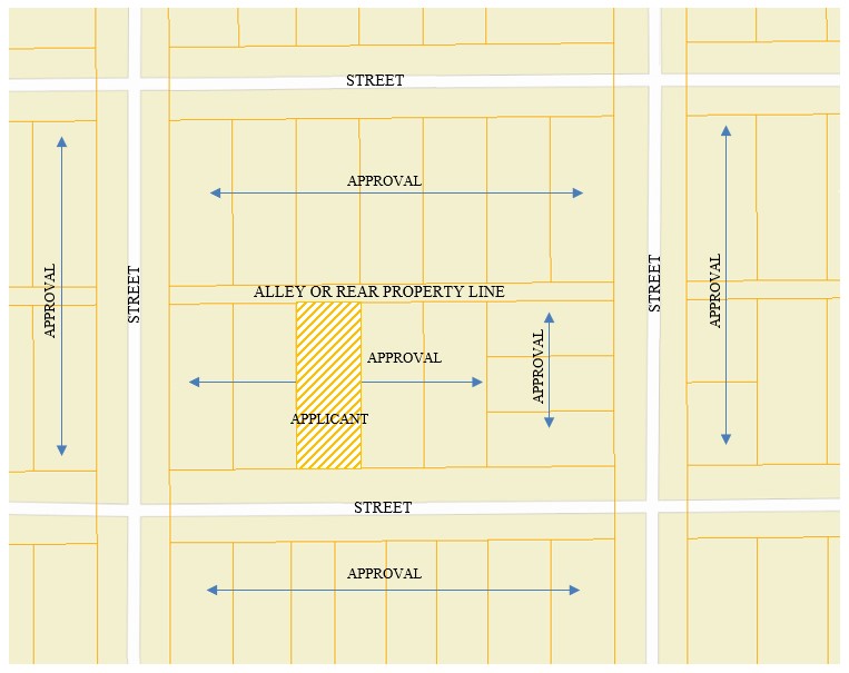
(ii) If the lot layout of the neighborhood is not in a grid block
pattern like described and depicted above, the applicant shall provide
written approval from those adjacent and near neighboring property owners
described as all properties a minimum of 200 feet from the applicant's
property boundaries and directly across the street from and behind those
properties 200 feet from the applicant's property boundaries.
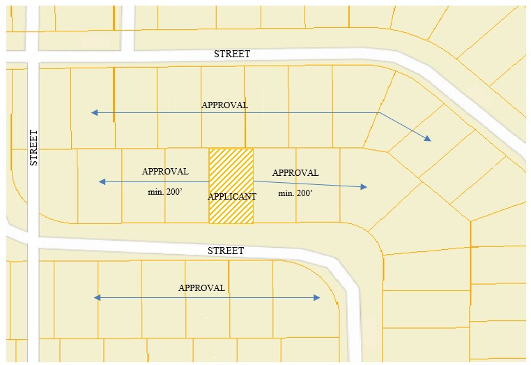
(2)
Hereinafter "hens", "bantam hens", and "ducks" will be referenced
collectively as "chickens".
(3) Number
and size:
a.
No more than a total of four (4) chickens (hens, bantam hens, ducks or any
combination of such animals) may be kept on any one (1) parcel as an
accessory use to the one primary single-family detached structure.
b.
Each chicken may be up to a maximum of five (5) lbs. in weight.
(4)
Use and ownership:
a.
The principal use of the property shall be a detached single-family
dwelling.
b. The
permit applicant shall be the owner and resident of the property, or if a
rental property then the tenant/lessee shall be the permit applicant with a
written consent statement from the property owner.
(5)
Setbacks and placement:
a.
A person shall not keep chickens in any location on the property other than
in a chicken enclosure in the rear yard.
b.
No chicken enclosure or coop shall be located closer than ten (10) feet to
any property line of an adjacent property.
c.
No chicken enclosure or coop shall be located closer than forty (40) feet to
any residential structure on another person's property.
d.
No chicken coop shall be located closer than ten (10) feet to any other
structure on the permitted lot for fire safety prupsoes.
(6)
Coops and enclosures:
a.
Chickens shall be provided with a covered, fenced, predator-proof coop
and/or enclosure that is well-ventilated and designed to be easily accessed
for cleaning.
b.
Chickens must be kept in a chicken enclosure at all times.
c.
Chickens shall have access to an outdoor enclosure that is adequately fenced
to contain the chickens on the property and to prevent predators from access
to the chickens.
d.
Chicken coops shall contain at least four (4) square feet of floor area per
chicken.
e.
Chicken enclosures shall provide at least ten (10) square feet of open area
per chicken.
f.
No chicken coop and enclosure combined shall exceed ninety (90) square feet
of floor area or exceed seven (7) feet in height.
g. All
chicken coops and enclosures shall be constructed and/or repaired to prevent
rats, mice, or other rodents from being harbored underneath, within, or
within the walls of the coop/enclosure.
h. All
electrical installations shall meet or exceed the applicable National
Electrical Code requirements. No temporary wiring (i.e. extension cords,
etc.) shall be permitted.
(7)
Sanitation:
a.
Coops and enclosures must be kept in a sanitary condition and free from
offensive odors to neighboring properties and prevent conditions that are
unsanitary or unsafe. Coops and enclosures must be cleaned on a regular
basis to prevent the accumulation of waste.
b.
All feed and other items associated with the keeping of chickens that are
likely to attract or to become infested with or infected by rats, mice, or
other rodents shall be protected so as to prevent rats, mice, or other
rodents from gaining access to or coming into contact with the food and
other associated items.
(8)
Roosters and crowing hens:
a.
No person shall keep roosters or any hens which have developed the
rooster-like quality of crowing or making crowing-like sounds
(9)
Slaughtering:
a.
There shall be no slaughtering of chickens outdoors or where the process can
be seen by neighbors or the general public.
(10) Running at large:
a.
Any chicken, permitted under this section, shall not be running at large on
any of the public ways or upon the property of another.
b.
When a chicken is caught running at large, it shall be addressed pursuant to
Sec. 4-6 of this Code.
(11) Search,
Examination, Revocation:
a. A
person who has been issued a permit shall freely and voluntarily consent to a
search and examination of a chicken coop and enclosure on the permittee's
property upon demand by any police officer, code official or zoning official
b.
If any of the requirements contained in this section are not complied with,
the city may revoke any permit granted under this section and/or initiate
prosecution of the permit holder and/or any other person violating this
Code.
(12) Permit
Nontransferable:
a.
Any permit issued under this section shall be a personal privilege granted
to the Applicant at the specific location named therein and shall not be
subject to transfer. In the event a new tenant leases property for
which a permit was previously issued to a prior tenant, the new tenant is
required to obtain his/her/their own permit in order to keep chickens on the
leased property.
Source: Ord. No. 4099, § 4, 7-17-95; Ord.
No. 4603, § 1, 9-16-02; Ord. No. 5059, § 2, 4-20-09; Ord. No. 5563,
§70, 8-20-18; Ord. No. 5799, §13, 9-6-22; Ord. No.
5825, §3, 4-3-23;
Secs.
27-296--27-300. Reserved.
ARTICLE
X. LANDSCAPING AND SCREENING
Sec. 27-301.
Purpose.
The Landscaping and Screening Regulations provide additional guidance on the
development of sites within Norfolk by addressing landscaping and screening
requirements. They are designed to improve the appearance of the
community; buffer potentially incompatible land uses from one another; and
conserve the value of properties within the city.
Source: Ord. No. 4603, § 1, 9-16-02
Sec. 27-302.
Applicability.
The provisions of this article shall apply to all new development on each lot
or site upon application for a building permit, except for the following:
(1)
Reconstruction or replacement of a lawfully
existing use or structure following a casualty loss.
(2) Remodeling, rehabilitation, or improvements to
existing uses or structures which do not substantially change the location of
structures, parking, or other site improvements.
(3)
Additions or enlargements of existing uses or
structures which increase floor area or impervious coverage area by less than
20 percent. Where such additions or enlargements are 20 percent or
greater, these provisions shall apply only to that portion where the new
development occurs.
Source: Ord. No. 4603, § 1, 9-16-02;
Ord. No. 5292, § 1, 6-2-14
Sec.
27-303. Landscaping Requirements.
Landscaping shall be required adjacent to each street property line and within
street yards as set forth in the table designated as Sec. 27-305. This
required area excludes driveways or parking lot entrances.
Source: Ord. No. 4603, § 1, 9-16-02
Sec.
27-304. Landscaping Materials and Installation Standards.
(a) Approved plant materials. Plant and landscaping materials set forth
in Sec. 27-311 of this Code shall be installed in required landscaped areas or bufferyards. All plant materials shall conform in size, species and
spacing with the requirements of this article.
(b)
Use of inorganic landscaping materials. No artificial trees, shrubs,
plants or turf shall be used to fulfill the minimum requirements for landscaping.
Inorganic materials, such as stone or decorative pavers, may be used provided
that such material does not comprise more than 35% of the minimum required
landscaped area. Other concrete and/or asphalt pavement surfaces may not be used within the minimum required landscaped area, except for
driveways and walkways.
Source: Ord. No. 4603, § 1, 9-16-02
Sec.
27-305. Required Landscape Depth.
|
Zoning District
|
Depth
of Landscaping Adjacent to Street Property Line
Or % of required front yard
|
|
|
|
|
A
|
50% of
required front yard
|
|
R-R
|
50% of
required front yard
|
|
S-R
|
50% of
required front yard
|
|
R-1
|
50% of
required front yard
|
|
R-2
|
50% of
required front yard
|
|
R-3
|
50% of
required front yard
|
|
R-M
|
15 feet
|
|
R-T
|
10 feet
|
|
R-O
|
20 feet
|
|
O-D
|
15 feet
|
|
C-1
|
15 feet
|
|
C-2
|
No
Requirement
|
|
C-2A
|
10 feet
|
|
C-3
|
10 feet
|
|
B-P
|
20 feet
|
|
I-1
|
10 feet
|
|
I-2
|
No
Requirement
|
|
I-3
|
10
feet
|
Source: Ord. No. 4603, § 1, 9-16-02;
Ord. No. 5799, § 12, 9-6-22;
Sec. 27-306. Bufferyard
Provisions.
(a) These provisions apply when use is established in a more intensive zoning
district (District 1) which is adjacent to a less intensive zoning district
(District 2). The owner, developer, or operator of the use within
District 1 shall install and maintain a landscaped bufferyard on his or her lot
or site, as set forth in this section. Bufferyard requirements apply only
to those districts indicated in the table designated as Sec. 27-307.
Bufferyards are not required of single-family, two-family or duplex use types
in the more intensive zoning district.
(1)
The bufferyard dimensions set forth in Sec. 27-307 apply to zoning districts
which share a common lot line or are adjacent but separated by an intervening
alley.
(2) When a street
separates adjacent zoning districts requiring a bufferyard, the size of the
bufferyard shall be one-half the required bufferyard set forth in Sec. 27-307.
(3) Each required
bufferyard must be entirely landscaped, pervious, and free of paved areas, access ways,
storage, or other disturbances.
(b) When a zoning district classification is
changed to allow for a less intensive use to abut an area where Sec. 27-307
would require a bufferyard, then the bufferyard required by Sec. 27-307 shall be
located on the property in the less intensive zoning district (District 2).
These provisions apply when use is established in a less intensive zoning
district (District 2) which is adjacent to a more intensive zoning district
(District 1). The owner, developer, or operator of the property
establishing a use in the less intensive zoning district (/District 2) shall
install and maintain a landscaped bufferyard on his or her lot or site, as set
forth in this section. Bufferyard requirements apply only to those
districts indicated in the table designated as Sec. 27-307. Bufferyards
are not required of single-family, two-family or duplex use types in the more
intensive zoning district.
(1) The
bufferyard dimensions set forth in Sec. 27-307 apply to zoning districts which
share a common lot line or are adjacent but separated by an intervening alley.
(2) When a
street separates adjacent zoning districts requiring a bufferyard, the size of
the bufferyard shall be one-half the required bufferyard set forth in Sec.
27-307.
(3)
Each required bufferyard must be entirely landscaped, pervious, and free of
paved areas, access ways, storage, or other disturbances.
When a zoning classification is changed that
results in transferring the bufferyard requirements from the more intensive
zoning district to the less intensive zoning district as set forth in this
subsection, then the zoning official shall cause to be filed of record an
affidavit stating that the less intensive zoning district has been rezoned and,
as a result, the bufferyard requirements of this Code are required to be met on
the less intensively-zoned property. Further, said affidavit shall be
indexed against all property adjoining the property of the less
intensively-zoned district which is responsible for meeting bufferyard
requirements.
Source: Ord. No. 4603, § 1, 9-16-02;
Ord. No. 5292, § 2, 6-2-14; Ord. No. 66, § 66, 8-20-18;
Sec. 27-307. Bufferyard
Requirements.
District 1
(More Intensive District)
(Note 2) |
District 2
(Less Intensive Adjacent District) |
A, R-R, S-R, R-1, R-2
(Note 1) |
R-3, R-M, R-O
(Note 1) |
|
R-3
|
20 feet
|
--- |
|
R-M |
20 feet
|
--- |
|
R-T |
20 feet |
--- |
|
O-D |
15 feet
|
--- |
|
C-1 |
15 feet
|
15 |
|
C-2 |
--- |
--- |
|
C-2A |
15 feet
|
15 |
|
C-3 |
30 feet
|
20 |
|
BP |
25 feet
|
25 |
|
I-1 |
40 feet
|
40 |
|
I-2 |
100 feet |
100 |
|
I-3 |
40 feet |
40 |
|
Note 1: Applies
only to residential uses previously established in the zoning district.
Note 2: Buffer requirements do not apply to
single-family or duplex residential uses established in District 1
|
Source: Ord. No. 4603, § 1, 9-16-02;
Ord. No. 5799, § 12, 9-6-22;
Sec. 27-308. Screening
standards.
(a) Application. Screening
required by this article shall be erected, placed and maintained by the owner,
developer, or operator of the property in the more intensive zoning district
unless specifically otherwise provided. Screening is required between
adjacent zoning districts indicated in Code Sec. 27-307 when one or more of the
following conditions in the more intensive zoning district is directly visible
from and faces toward the boundary of the less intensive zoning district:
(1)
The rear elevation of buildings.
(2)
Outdoor storage areas or storage tanks, unless otherwise screened.
(3)
Loading docks, refuse collection points, and other service areas.
(4)
Major machinery or areas housing a manufacturing process.
(5)
Major onsite traffic circulation areas or truck and/or trailer
parking.
(6)
Sources of glare, noise, or other environmental
effects.
Notwithstanding the conditions listed in (1) through
(6) above, screening between adjacent zoning districts indicated in Code Sec.
27-307 is required when a zoning district classification is changed to allow for
a less intensive use.
(b) Opaque barrier. An
opaque barrier having a density of not less than eighty percent (80%) per square
foot shall be provided which visually screens the conditions listed
in subsection (a) above from less intensive uses as follows:
(1)
A fence of solid-wall masonry, wood, louvered wood, metal,
vinyl, or similar materials, not less than six (6) feet nor more than eight (8)
feet high.
(2)
A landscaping screen, using evergreen or deciduous materials,
providing a hedge-like barrier and attaining a
minimum height of six feet within three years of planting.
(3)
A landscaped earth berm with a maximum slope of
three to one, rising no less than six feet above the existing grade of the lot
line separating the zoning districts.
(4)
Any combination of these methods that achieves
a cumulative height of six feet.
(5)
Whenever screening shall be required along a side yard lot line, screening
shall be reduced to a height of four (4) feet for that portion located
within twenty-five (25) feet of the front property line.
(c) Location of screening wall.
(1)
A screening wall or fence required to be located on a more
intensively-zoned district shall be installed in the required bufferyard.
(2) In the case
where a zoning district is changed to allow for a less intensive use to abut an
area where this section would require screening, then the screening required
herein shall be located on the property of the less intensive zoning district.
If the screening wall is to be constructed on the less intensive zoning
district, then the screening shall be installed within three (3) feet of the
property line separating the property located in the less intensively-zoned
district from the property located in the more intensively-zoned district.
When a zoning district classification is changed that results in
transferring the screening requirements from the more intensive zoning
district to the less intensive zoning district as set forth in this
subsection, then the zoning official shall cause to be filed of record an
affidavit stating that the less intensive zoning district has been rezoned
and, as a result, the screening requirements of this Code are required to be
met on the less intensively-zoned property. Further, said affidavit
shall be indexed against all property adjoining the property of the less
intensively-zoned district which is responsible for meeting screening
requirements.
(d) Screening, effect on drainage. Screening shall not adversely
affect surface water drainage.
(e) Permitted interruptions of screening. Screening may be
interrupted to provide access drives to service areas or for loading purposes
to buildings. Such breaks or interruptions shall not exceed 20% of the
length of the required screened area.
Source: Ord. No. 4603, § 1, 9-16-02;
Ord. No. 5292, § 3, 6-2-14
Sec. 27-309. Tree plantings.
One tree of an approved species, as set forth in Sec. 27-311 of this Code,
having a minimum caliper size of two inches shall be planted and maintained for
each 500 square feet of required landscaped area for each of the following
contexts:
(1)
In any landscaped area for office and
commercial uses only required by the minimum depth requirements, the bufferyard
requirements, or the parking lot interior landscaping requirements;
(2) In any
landscaped area for all uses within a B-P District required by the minimum depth
requirements, the bufferyard requirements, or the parking lot interior
landscaping requirements;
(3) In any landscaped area required by the
minimum depth requirements and the bufferyard requirements for industrial uses;
and
(4) In any
landscaped area required by the minimum depth requirements, the bufferyard
requirements, or the parking lot interior landscaping requirements for
townhouses without individual dwelling unit lot lines, multi-family uses and
tiny house (R-T) district developments.
Existing trees approved for
preservation shall be counted toward satisfaction of this requirement.
Source: Ord. No. 4603, § 1, 9-16-02;
Ord. No. 5655, § 1, 4-6-2020; Ord. No. 5799, § 12, 9-6-22;
Sec. 27-310. General
Provisions.
(a) Time of application. The provisions contained in this Article
shall be applied for each individual lot or site when an application for a
building permit on such lot is made. When required, a landscape plan
shall be submitted with each application for a building permit. Such plan
shall be reviewed by the zoning official for compliance with the provisions of
this section.
(b) Maintenance of required landscaping. Upon installation of
required landscape materials, each owner shall take appropriate actions to
ensure their continued health and maintenance. Required landscaping that
does not remain healthy shall be replaced consistent with this Article.
(c) Obstruction of view. Landscaping or screening installed in any
landscaped area shall not obstruct the view from or to any driveway approach,
street, alley, or sidewalk.
(d) Earth berm locations. All earth berm locations shall be
reviewed by the zoning official, or his or her designee to determine how the
berms shall relate to drainage and public utilities.
(e) Exceptions. A development may continue to comply with the bufferyard and screening requirements in effect at the time of issuance of its
original permit, regardless of whether an adjacent lot or site is subsequently
rezoned to a less intensive district which would otherwise require compliance
with bufferyard or screening provisions.
Source: Ord. No. 4603, § 1, 9-16-02
Sec. 27-311. Approved
landscaping materials.
The following are approved landscaping materials:
(a) Shrubs
(1) Evergreen:
| Scientific
Name |
Common Name |
| Junipers chinensis varieties |
|
| J. chinensis “Blaawsi” |
Blaaws Juniper |
| J. chinensis “Hetzil” |
Hetz Juniper |
| J. chinensis
“Maneyi” |
Maney Juniper |
| J. chinensis pfitzeriana |
Pfitzer Juniper |
| Juniperus communis varieties |
|
| J. communis
“Compressa” |
Compressa Juniper |
| J. communis “Depressa” |
Depressa Juniper |
| Juniperus sabina varieties |
|
| J. sabina |
Savin Juniper |
| J. sabina “Blue Danube” |
Blue Danube Juniper |
| J. sabina tamariscifolia |
Tamarix Savin Juniper |
| J. sabina “Von Ehron” |
Von Ehron Savin Juniper |
| Junipers virginiana “Globosa” |
Globe Eastern Red Cedar |
| J. virginiana
“Tripartita” |
Fountain Red Cedar |
| Picea abies varieties |
|
| P. abies “Nidiformis” |
Nidiformis Norway Spruce |
| Picea glauca
“Conica” |
Dwarf White Spruce |
| Pinus mugho mughus |
Dwarf Mugho Pine |
| Pinus nigra “Hornibrookiana” |
Hornibrook Austrian Pine |
| P. nigra “Pygmaea” |
Pygmy Austrian Pine |
| Pinus pumila |
Japanese Stone Pine |
| Pinus strobus varieties |
|
| P. strobus “Nana” |
Dwarf White Pine |
| Pinus sylvestris “Watereri” |
Waterer Scotch Pine |
| Taxus canadensis |
Canada Yew |
| Taxus cuspidata varieties |
|
| T. cuspidata expansa |
Spreading Japanese Yew |
| T. cuspidata
nana |
Dwarf Japanese Yew |
| Taxus x media varieties |
|
| T. x media “Hicksii” |
Hicks Anglojap Yew |
| T. x media “Taunton” |
Taunton Yew |
(2) Deciduous:
| Scientific Name |
Common Name |
| Acer ginnala |
Amur Maple |
| A. ginnala “Durand Dward” |
Dwarf Amur Maple |
| Acanthopanax sieboldianus |
Five-leaved Aralia |
| Alnus
rugosa |
Speckled Alder |
| Amorpha canescense |
Leadplant |
| Amorpha nana |
Fragrant False Indigo |
| Aralia hispida |
Bristly Sarsaparilla |
| Berberis koreana |
Korean Barberry |
| Berberis x
mentorensis |
Mentor Barberry |
| Berberis thunbergii varieties |
|
| B. thunbergii |
Japanese Barberry |
| B. thunbergii
“aurea” |
Golden Barberry |
| B. thunbergii “Crimson Pygmy” |
Crimson Pygmy Barberry |
| B. thunbergii “erecta” |
Truehedge Barberry |
| Buxus microphylla
“koreana” |
Korean Boxwood |
| Caragana arborescens varieties |
|
| C. arborescens |
Siberian Peashrub |
| C. arborescens “Tidy” |
Tidy Peashrub |
| C. arborescens “Pendula” |
Weeping Peashrub |
| Caragana frutex |
Russian Peashrub |
| C. frutex “Glove” |
Globe Russian Peashrub |
| Caragana microphylla |
Littleleaf Peashrub |
| Chaenomeles
japonica |
Japanese Quince |
| Chaenomeles speciosa |
Flowering Quince |
| Cornus alba varieties |
|
| C. alba “Siberica” |
Siberian Dogwood |
| Cornus amomum |
Silky Dogwood |
| Cornus mas |
Cornelian-cherry |
| Cornus
racemosa |
Gray Dogwood |
| Cornus sericea varieties |
|
| C. sericea |
Red Osier Dogwood |
| C. sericea
“Flaviramea” |
Yellowtwig Dogwood |
| C. sericea “Kelseyi” |
Kelsey Dwarf Redtwig Dogwood |
| Cotinus coggygria |
Smoketree |
| Cotoneaster species |
|
| Cotoneaster apiculata |
Cranberry Cotoneaster |
| Cotoneaster divaricata |
Spreading Cotoneaster |
| Cotoneaster horizontalis |
Rock Spray |
| Cotoneaster lucida |
Hedge Cotoneaster |
| Deutzia x lemoinei |
Lemoine Deutzia |
| Dirca palustris |
Leatherwood |
| Diervilla lonicera |
Bush Honeysuckle |
| Elaeagnus
umbellatus |
Autumn Elaeagnus |
| Euonymous alatus |
Winged Euonymous |
| E. alatus “Compactus” |
Dwarf Winged Euonymous |
| Euonymous bungeanus semipersistens |
Midsummer Euonymous |
| Euonymous atropurpurea |
Eastern Wahoo |
| Euonymous auropaea |
European Euonymous |
| Euonymous fortunei |
Wintercreeper |
| Forsythia x intermedia varieties |
|
| F. x intermedia “Karl Sax” |
Karl Sax Forsythia |
| F. x intermedia “Spring Glory” |
Spring Glory Forsythia |
| Forsythia x ovata |
Early Forsythia |
| Forsythia suspensa |
Weeping Forsythia |
| Hammamalis vernalis |
Vernal Witchhazel |
| Hammamalis virginiana |
Common Witchhazel |
| Hibiscus syriacus |
Rose-of-Sharon |
| Hippophae rhamnoides |
Sea-Buckthorn |
| Hydrangea arborescens |
Hills-of-Snow |
| Hypericum kalmionum |
Kalm St. Johnswort |
| Hypericum
prolificum |
Shrubby St. Johnswort |
| Ilex verticulata |
Winterberry |
| Kerria japonica |
Japanese Kerria |
| Kolkwitzia amabilis |
Beaty-bush |
| Ligustrum amurense |
Amur Privet |
| Ligustrum x ibolium |
Ioblium Privet |
| Ligustrum obtusifolium varieties |
|
| L. obtusifolium |
Border Privet |
| L. obtusifolium regelianum |
Regels Border Privet |
| Linder benzoin |
Spicebush |
| Lonicera x bella albida |
White Bell Honeysuckle |
| Lonicera
fragrantissima |
Whiner Honeysuckle |
| Lonicera maackii |
Amur Honeysuckle |
| Lonicera morrowii |
Morrow Honeysuckle |
| Lonicera tatarica varieties |
|
| L. tatarica |
Tatarian Honeysuckle |
| Lonicera x xylosteum “Claveyi” |
Claveys Dwarf Honeysuckle |
| Mallus sargentii |
Sargent Crabapple |
| Myrica pensylvanica |
Bayberry |
| Philadelphus varieties |
|
| Philadelphus x lemoinei var. |
Lemoine Mock-Oranges |
| Philadelphus coronarius |
Sweet Mock-Orange |
| Philadelphus “Frosty Morn” |
Frosty Morn Mock-Orange |
| Physocarpus opulifolius |
Eastern Ninebark |
| Potentilla fruiticosa var. |
|
| P. fruiticosa |
Shrubby Cinquefoil |
| P. fruiticosa “Grandiflora” |
|
| P. fruicosa “Mandshuria” |
|
| Prunus varieties |
|
| Prunus besseyi |
Western Sand Cherry |
| Prunus x cistena |
Purpleleaf Sand Cherry |
| Prunus glandulosa |
Dwarf Flowering Almond |
| Prunus japonica |
Nakai Chinese Bush Cherry |
| Prunus maritima |
Beach Plum |
| Prunus x pumila |
Hansen’s Bush Cherry |
| Prunus tomentosa |
Manchu Cherry |
| Prunus triloba |
Flowering Almond |
| Rhamnus frangula “Columnaris” |
Columnar Alder Buckthorn |
| Rhododendron carolinianum varieties |
P.V.M Rhododendrons |
| Rhododendron x “Northern Lights” varieties |
|
| Rhodotypos scandens |
Black Jetbead |
| Rhus aromatica |
Fragrant Sumac |
| Rhus copallina |
Shining Sumac |
| Rhus glabra |
Smooth Sumac |
| Rhus typhina |
Staghorn Sumac |
| Ribes alpinum |
Alpine Currant |
| Ribes
odoratum |
Clove Currant |
| Rosa varieties |
|
| Rosa blanda |
Meadow Rose |
| Rosa centifolia |
Cabbage Rose |
| Rosa hugonsis |
Father Hugo Rose |
| Rosa roxburghii |
Roxburgh Rose |
| Rosa rugosa |
Rugosa Rose |
| Rosa spinosissima |
Scotch Rose |
| Rosa virginiana |
Virginia Rose |
| Salix lucida |
Shining Willow |
| Salix purpurea |
Red Osier |
| Sambucus canadensis |
American Elder |
| Sheperdia canadensis |
Russet Buffaloberry |
| Sorbaria sorbifolia |
Ural False Spiraea |
| Spiraea species varieties |
|
| Spiraea albiflora |
Japanese White Spiraea |
| Spiraea x bumalda varieties |
|
| S. x bumalda “Anthony Waterer” |
Anthony Waterer Spiraea |
| Spiraea japonica alpina |
Alpine Japanese White Spiraea |
| Spiraea x margaritae |
Margarita Spiraea |
| Spiraea nipponica
rotundifolia |
Big Nippon Spiraea |
| Spiraea prunifolia |
Bridalwreath Spiraea |
| Spiraea triloba |
Treelobe Spiraea |
| Spiraea x vanhouttei |
Vanhoutte Spiraea |
| Stphylea trifolia |
American Bladdernut |
| Symphoricarpos albus laevigatus |
Snowberry |
| Symphoricarpos x chenaultii |
Chenault Coralberry |
| Symphoricarpos
orbiculatus |
Indian Current |
| Syringa varieties |
|
| Syringa x chinensis |
Chinese Lilac |
| Syringa oblata
dilatata |
Korean Early Lilac |
| Syringa x persica |
Persian Lilac |
| Syringa vollosa |
Late Lilac |
| Syringa
vulgaris |
Common Lilac |
| Tamarix petandra |
Five-Stamen Tamarix |
| Viburnum species varieties |
|
| Viburnum x
carlcephalum |
Fragrant Snowball |
| Viburnum cassinoides |
Witherrod |
| Viburnum dentatum |
Arrowwood |
| Viburnum x
juddii |
Judd Viburnum |
| Viburnum lantana |
Wayfaring Tree |
| Viburnum lentago |
Nannyberry |
| Viburnum plicatum |
Japanese Snowball |
| Viburnum prunifolium |
Black Haw |
| Viburnum sieboldii |
Siebold Viburnum |
| Viburnum trilobum |
American Cranberry Bush |
| Weigela florida |
Old-Fashioned Weigela |
| Yucca filamentosa |
Adams-needle |
(b) Trees:
(1) Evergreen:
|
Scientific
Name |
Common Name |
| Abies concolor |
White Fir |
| Juniperus chinensis |
Chinese Juniper |
| J. chinensis
“Ames” |
Ames Juniper |
| J. chinensis columnaris |
Blue Columnar Chinese Juniper |
| J. chinensis “Keteleeri” |
Keteleer Chinese Juniper |
| J. chinensis varieties |
|
| Juniperus scopulorum |
Rocky Mountain Juniper |
| J. scopulorum “Blue
Heaven” |
Blue Heaven Juniper |
| J scopulorum “Cologreen” |
Cologreen Juniper |
| J. scopulorum varieties |
|
| Juniperus virginiana |
Eastern Red Cedar |
| J. virginiana “Burkii” |
Burk Red Cedar |
| J. virginiana “Canaertii” |
Canaert Red Cedar |
| J. virginiana
pendula |
Weeping Red Cedar |
| J. virginiana varieties |
|
| Picea abies |
Norway Spruce |
| Picea
glauca |
White Spruce |
| Picea omorika |
Serbian spruce |
| Picea pungens |
Colorado Spruce |
| Pinus Banksiana |
Jack Pine |
| Pinus nigra |
Austrian Pine |
| Pinus resinosa |
Red Pine |
| Pinus strobus |
Eastern White Pine |
| Pinus sylvestris |
Scotch Pine |
| Pseudotsuga
menzeisii |
Douglas Fir |
| Taxus cuspidata |
Japanese Yew |
| Taxus media |
Intermediate Yew |
| Thuja occidentalis |
Eastern Arborvitae |
| Tsuga canadensis |
Canada Hemlock |
(2) Deciduous:
| Scientific
Name |
Common Name |
| Acer ginnala |
Amur Maple |
| Acer nigrum |
Black Maple |
| Acer platanoides |
Norway Maple |
| A. platanoides “Summershade” |
Summershade Maple |
| A. platanoides “Columnare” |
Columnar Norway Maple |
| A. platanoides varieties |
|
| Acer rubrum |
Red Maple |
| Acer saccharinum “Blair” |
Blair Soft Maple |
| Acer saccharum |
Sugar Maple |
| Acer tataricum |
Tatarian Maple |
| Amelanchier canadensis |
Shadblow Serviceberry |
| Amelanchier graniflora |
Apple Serviceberry |
| Amelanchier laevis |
Allegheny Serviceberry |
| Betula
lenta |
Sweet Birch |
| Betula nigra |
River Birch |
| Carpinus betulus |
European Hornbeam |
| Carya ovata |
Shagbark Hickory |
| Catalpa speciosa |
Northern Catalpa |
| Celtis occidentalis |
Common Hackberry |
| Cercis canadensis |
Eastern Redbud |
| Cornus alternifolia |
Pagoda Dogwood |
| Cornus
florida |
Florida Dogwood |
| Cornus mas |
Cornelian Cherry |
| Crataegus mollis |
Downy Hawthorn |
| Crataegus crus-galli |
Cockspur Thorn |
| Crataegus oxycantha |
English Hawthorn |
| Crataegus
phaenopyrum |
Washington Hawthorn |
| Elaeagnus angustifolia |
Russian Olive |
| Euonymous atropurpurea |
Eastern Wahoo |
| Euonymous
europaea |
European Spindle Tree |
| Fraxinus americana “Rosehill” |
Rosehill Ash |
| Fraxinus pennsylvanica |
Red Ash |
| Fraxinus pennsylvanica lanceolata |
Green Ash |
| Fraxinus quadrangulata |
Blue Ash |
| Ginkgo Biloba |
Ginkgo |
| Gledista tricanthos inermis |
Thornless Honey Locust |
| Gymnocladus dioicus |
Kentucky Coffee Tree |
| Koelreuteria paniculata |
Goldenrain Tree |
| Larix laricina |
American Larch |
| Liriodendron tulipifera |
Tulip Tree |
| Maclura
pomifera |
Osage-orange |
| Magnolia soulangeana |
Saucer Magnolia |
| Magnolia stellata |
Star Magnolia |
| Malus |
Crab Apples |
| Ostrya virginiana |
American Hophornbeam |
| Phellondendron amurense |
Amur Cork Tree |
| Phellodendron sachalinense |
Sakhalin Cork Tree |
| Platanus acerofolia |
London Planetree |
| Platanus occidentalis |
American Planetree |
| Populus deltoides var. |
Cottonless Cottonwoods |
| Prunus maackii |
Amur Choke Cherry |
| Prunus padus commutata |
Harbinger Bird Cherry |
| Prunus sargentii |
Sargent Cherry |
| Prunus
serotina |
Black Cherry |
| Prunus virginiana |
Common Choke Cherry |
| Pyrus calleryana “Bradford” |
Bradford Pear |
| Quercus borealis |
Red Oak |
| Quercus bicolor |
Swamp White Oak |
| Quercus coccinea |
Scarlet Oak |
| Quercus imbricaria |
Shingle Oak |
| Quercus macrocarpa |
Bur Oak |
| Quercus muhlenbergi |
Chinkapin Oak |
| Quercus palustris |
Pin Oak |
| Quercus robur |
English Oak |
| Salix
alba |
White Will |
| Salix alba tristis |
Golden Weeping Willow |
| Salix blanda |
Wisconsin Weeping Willow |
| Salix matsudana “Tortuosa” |
Corkscrew Willow |
| Salix discolor |
Pussy Willow |
| Salix petandra |
Laurel Will |
| Sophoroa japonica |
Japanese Pagoda Tree |
| Sorbus alnifolia |
Korean Mountain Ash |
| Syringa reticulata |
Japanese Tree Lilac |
| Tilia americana |
American Linden |
| Tilia cordata |
Littleleaf Linden |
| Tilia euchlora |
Crimean Linden |
| Tilia mongolica |
Mongolian Linden |
| Viburnum prunifolium |
Blackhaw Viburnum |
| Viburnum sieboldii |
Siebold Viburnum |
| Zelkova serrata |
Japanese Zelkova |
(c) Ground covers:
|
Scientific
Name |
Common Name |
| Aegopodium
podogaria |
Bishop’s Goutweed |
| Ajuga reptans |
Carpet Bugle |
| Akebia quinata |
Five-leaf Akebia |
| Convalaria majalis |
Lily-of-the-Valley |
| Coronilla varia |
Crownvetch |
| Cotoneaster apiculata |
Cranberry Cotoneaster |
| Euonymous fortunei |
Wintercreeper |
| Euonymous fortunei varieties |
|
| Euonymous obovatus |
Running Euonymous |
| Euphorbia cyparissias |
Cypress Euphorbia |
| Forsythia x intermedia |
“Arnold’s Dward” |
|
Arnold’s Dward Forsythia |
| Hosta varieties |
Plantain-lily |
| Juniperus chinensis sargentii |
Sargent Juniper |
| Juniperus chinensis varieties |
|
| Juniperus communis “Depressa” |
Depressa Juniper |
| Juniperus horizontalis admirabilis |
Prostrate Juniper |
| Juniperus horizontalis varieties |
|
| Juniperus procumbens “Nana” |
Dwarf Japgarden Juniper |
| Juniperus procumbens varieties |
|
| Juniperus sabina “Blue Danube” |
Blue Danube Juniper |
| Juniperus sabina varieties |
|
| Lonicera dioica |
Limber Honeysuckle |
| Lonicera japonica halliana |
Hall’s Japanese Honeysuckle |
| Lycium chinense |
Chinese Matrimony Vine |
| Lysimachia nummularia |
Moneywort |
| Nepeta mussini |
Mussin’s Catnip |
| Pachysandra terminalis |
Japanese Spurge |
| Phlox subulata |
Moss Phlox |
| Polygonum x renoutria |
Renoutria Fleeceflower |
| Potentilla tridentata |
Wineleaf Potentilla |
| Sedum acre |
Goldmoss |
| Sedum lydium |
Lydium Stonecrop |
| Spiraea albiflora |
Japanese White Spiraea |
| Spiraea x bumalda “Norman” |
Norman Spiraea |
| Spiraea japonica alpina |
Alpine Japanese White Spiraea |
| Symphoricarpos x
chenaultii |
Hancock Coralberry |
| Vinca minor |
Creeping Periwinkle |
| Viola varieties |
Violets |
(d) Vines:
|
Scientific
Name |
Common Name |
| Parthenocissus quinquifolia |
Virginia Creeper |
| Parthenocissus quinquifolia engelmanii |
Engelman Virginia Creeper |
| Campsis radicans |
Trumpet Vine |
| Campsis x tagliabuana
“Madame Galen” |
Madame Galen Trumpet |
| Euonymus fortunei |
Winter Creeper |
| Hedera helix |
English Ivy |
| Hydrangea anomala
petiolaris |
Climbing Hydrangea |
| Parthenocissus tricuspidata |
Japanese Creeper (Boston Ivy) |
| Aristolochia macrophylla |
Dutchman’s Pipe |
| Celastrus flagelloris |
Korean Bittersweet |
| Celastrus orbiculatus |
Oriental Bittersweet |
| Celastrus
scandens |
American Bittersweet |
| Lonicera henryi |
Henry Honeysuckle |
| Lonicera japonica “Halliana” |
Halls Honeysuckle |
| Lonicera sempervirens |
Trumpet Honeysuckle |
Source: Ord. No. 4603, § 1, 9-16-02
Secs.
27-312--27-320. Reserved.
ARTICLE
XI. SIGNS
Sec. 27-321. Generally -
Signs.
(a) Signs shall be permitted in all
districts as provided in this article. All signs visible from any point
beyond the lot line shall be subject to this article. No sign shall be
located within any required yard area other than in the front yard, nor closer
to the front lot line than required hereinafter. Signs shall not be
located within the area of the required side yard extended to the front street
line. No signs shall be placed or located so as to encroach into the
public right-of-way of any street or highway, except for those defined as public
signs in Sec. 27-2. If the public signs, as defined, are not of an
approved design according to the Manual on Uniform Traffic Control Devices
(MUTCD), they shall be permitted only after an agreement is entered into with
the city, approved by the council, showing specific locations, size and design,
prior to placement.
(b) All permanent signs in
place and in existence at the time of the effective date of this section,
except those signs which have any part in or projecting into the right-of-way,
and further excepted as provided in subsection (4) hereof, shall be
grandfathered and considered as legal nonconforming signs. The copy area
of said grandfathered signs may be changed or the copy thereon replaced;
provided, however, the sign area shall not be enlarged beyond the sign area of
said sign on the effective date of this section. In addition, all sign
bases and supporting structures for signs in existence on the effective date of
this section, and upon which no sign is then located, may, upon application to
the Planning and Development Department, be permitted to place a sign thereon which meets the sign
area requirements of the zoning district in which the sign base or supporting
structure is located.
(c) Any sign in place and in
existence at the time of the effective date of this section that subsequently
has to be moved or relocated as a result of any public project or improvement,
shall be allowed to be relocated at the same setback from the new property line
as it was from the former property line, except that no part of any such sign
shall extend beyond the property line into the right-of-way.
(d) Except in the C-2 zoning
district and subject to the provision of subsection (2) hereof, any sign which
projects into the public right-of-way at the time of the effective date of this
section may remain until such time that (1) any structural alterations are made
to the sign or (2) the sign area or structure has been destroyed or damaged to
the extent that the sign is not functional in its damaged condition.
Should either of the foregoing conditions occur, the sign shall then be made to
conform to this chapter.
(e) All signs, their supports, braces, guys, anchors and electrical
equipment shall be maintained in good repair and in a safe, neat, clean and
attractive condition. Painted display surfaces, structures and supports
of all signs shall be painted or otherwise treated when required by the
zoning official or his or her designee.
(f) Obsolete signs shall be
removed by the sign owner or the owner's agent. The zoning official or
his or her designee may grant an extension of said six (6) month period for up
to six (6) months. Only one such extension shall be granted. Should
the sign owner or owner's agent fail to remove said obsolete sign after the
time limitation has expired, the city shall remove said sign with the cost of
such removal to be levied and specially assessed against the property where the
sign is located, and be collected and enforced as a special assessment.
(g) Other than message signs
no larger than twenty-four (24) square feet where permitted, flashing signs or
lights, the use of stroboscopic lights, rotary beacons, unshielded flood
lights, exposed incandescent bulbs exceeding thirty (30) watts or any lighting
which may be confused with traffic control devices or any direct or reflected
lighting that creates a traffic hazard shall be prohibited.
(h) Destination signs shall
be allowed in all zoning districts and may be placed in the public right-of-way
only on arterial streets with the approval of the zoning official or his or
her designee; provided, however, that the placement of said sign shall meet the
criteria in the most recent copy of the Manual on Uniform Traffic Control
Devices (MUTCD) adopted by the Nebraska Department of Roads.
(1)
Destination signs shall have a reflectorized white copy on a green sign
area. Said signs shall conform to the specifications prescribed by the
Nebraska Department of Roads, and said signs shall be paid for by the person(s)
or entity desiring said sign.
(2)
Size of destination signs shall depend on the length of copy, size of lettering
and spacing necessary for proper legibility. Destination signs shall be
designed to fit on the standard rectangular sizes given in the standard highway
signs booklet prepared by the Federal Highway Administration as the same may
from time to time be amended. Lettering shall not exceed eight (8) inches
in height. Copy shall be kept to a minimum to be legible and shall not
exceed three (3) lines of copy. Arrows may be used in the copy to
indicate directions toward destinations.
(3)
Cost of installation, maintenance and replacement of destination signs shall be
the responsibility of the person(s) or entity applying for said sign.
(i) No signs or lettering
shall be placed on or affixed to moving vehicles and/or trailers or to those
which are parked on public or private property, so as to be visible from a
public right-of-way where the apparent purpose is to advertise a product,
political candidate, or to direct people to a business or activity located on
the same or nearby property; provided, however, that this section shall not
prohibit signs or lettering placed on or affixed to vehicles and/or trailers
where the sign or lettering is incidental to the primary use of the vehicle or
trailer; and provided further that this section shall not prohibit the use of
what is commonly referred to as “bumper stickers” on motor vehicles or
trailers. Signs permanently affixed to or an integral part of a motor
vehicle are exempt from this section.
(j) Except in the C-2 zoning
district or as otherwise provided in this chapter, no sign or promotional
device shall be erected or hung over any sidewalk, street, avenue or alley
within the city other than street identification signs, except the mayor and
city council may issue a special permit to civic, philanthropic, educational or
religious organizations for the hanging of a temporary promotional device;
provided, that said promotional device is hung with the lowest point thereof
not less than fourteen (14) feet above a sidewalk, street, avenue or
alley. Said promotional devices shall be exempt from permit fee upon
application to the Planning and Development Department. In addition,
promotional devices may display advertising or promotions as a temporary
building sign or as a freestanding temporary sign for a period of up to one
hundred twenty (120) hours without a permit; provided, however, the Planning and
Development Department is notified prior to their display. Failure to
notify the Planning and Development Department shall subject the promotional device
to regulation as a temporary sign and be subject to obtaining of a temporary
sign permit.
Source: Ord. No. 4603, § 1, 9-16-02;
Ord. No. 5563, § 67, 8-20-18; Ord. No. 5783, § 2,
6-6-22;
Sec.
27-322. Signs, where prohibited.
(a) It shall be unlawful for
any person to situate, erect, place, operate, use or allow to be situated,
erected, operated or used, any mobile, portable, temporary, permanent, secured,
fastened, fixed or other type of sign or advertising device, except in the
manner as set forth in Sec. 27-321 of this Code, by operating said sign upon a
street, alley, public right-of-way, or across any sidewalk line within the city
or in the front yard setback of any zoning district except as the same may be
authorized by the height and yard regulations of the zoning district where said
sign is to be located. These provisions shall not apply to permanent
advertising signs in a C-2 zoning district that are permanently attached to the
main structure thereon, which overhang into the public right-of-way, and which
have been approved by the Nebraska Department of Roads.
(b) Any temporary sign that
does not meet the criteria as set forth in subsection (a) above shall be
considered to be a nonconforming sign; and such sign shall be abated, removed
or made to comply herewith within ninety (90) days of the effective date of
this section. If not done within the time limit as set forth herein, the
city may proceed to bring said sign within compliance by any action either at
law or in equity.
(c) Any person who violates
the provisions of this section shall be guilty of an offense and penalized
pursuant to Sec. 1-16 of this Code.
Source: Ord. No. 4603, § 1, 9-16-02
Sec.
27-323. Temporary signs, when and where authorized.
(a) A temporary sign as
defined by Sec. 27-2 of this Code shall be allowed in any zoning district
within the city subject only to the following restrictions:
(1)
The temporary sign may be located within the front or
side yard, however, the sign shall be set in accordance with the provisions of
subsection (8) of this section. In no event shall a temporary sign be
allowed to be located within the public right-of-way.
(2)
There shall be only one (1) temporary sign allowed per
premises; and only one (1) such sign shall be allowed at any one (1) time on
any premises having more than one (1) business or use.
(3)
The restrictions of subparagraph (2) above shall not
apply to an itinerant merchant, peddler, solicitor, street vendor or temporary
merchant who is holding any valid permit required by Chapter 13, Article VIII
of this Code. Said itinerant merchant, peddler, solicitor, street vendor
or temporary merchant shall be allowed one (1) temporary sign during the period
of time they are holding a valid permit required by this Code.
(4)
Any temporary sign which is placed within the public
right-of-way as prohibited by this section is hereby declared to be a public
safety hazard and shall be subject to being immediately towed or removed by the
city. Any temporary sign which is placed in a location that is prohibited
by this section, other than in the public right-of-way, shall be subject to
being towed or removed by the city. Before being subject to being towed
or removed, or a citation issued for a violation thereof, the owner of the sign
or the owner or occupant of the premises where said sign is located shall be
notified by the enforcing officer in writing and given four (4) hours to remove
the same from the premises. If the sign is not removed within said time
limit, the city may proceed to tow or remove said sign without further notice
to the owner of the sign or the owner or occupant of the premises or issue a
citation for the violation of this section. Any sign so removed shall be
stored in the street division’s enclosed yard and not released until a fee as
set forth in Section 2-5
of this Code shall have been paid to the city.
(5) In addition to the provision of subsection (4) of this
section, any person who violates the provisions of this section shall be guilty
of an offense and penalized pursuant to Sec. 1-16 of this Code. Any one
(1) or more of the following persons shall be prima facie liable for the
violation of this section: The tenant of the premises, the manager of a
corporation occupying the premises, the owner of the premises, the installer of
the sign, or the owner of the sign.
(6)
The Planning and Development Department, Public Works
Department and the Police
Division shall have joint authority for the enforcement of this section.
(7)
One (1) non-illuminated sign per premises, not more
than eighty (80) square feet in area, listing names of architects, engineers,
builders, contractors or future tenants may be erected on the premise of the
building being constructed, providing such sign shall be removed upon
completion of building.
(8) There shall be two (2) classes of temporary signs
which shall have the following conditions attached:
a. Class I temporary signs.
1. Total sign area shall not
exceed eight (8) square feet.
2. Maximum sign height shall
not exceed six (6) feet.
3.
Minimum front or side yard setback for Class I temporary signs shall be five
(5) feet.
4.
Class I temporary signs shall be allowed in all zoning districts.
5.
No temporary signs shall be allowed within the sight triangle as referenced in
Sec. 27-290 of this Code.
b.
Class II temporary signs.
1. Total sign area shall not
exceed thirty-two (32) square feet.
2. Maximum sign height shall
not exceed six (6) feet.
3.
Front yard setback shall be the same as is required for permanent signs in the
district where the sign is located, provided, however, that in no instance
shall the setback be less than five (5) feet.
4.
No Class II temporary sign shall be permitted in residential zoning districts
except signs advertising real estate for sale.
(9) Signs in support of, or opposition to, a candidate
or proposition which is the subject of a general, primary or special election
shall not be subject to the provisions of subsection (2) of this section and
shall be removed within five (5) days following the election.
(10)
Signs advertising real estate for sale shall be
removed within five (5) days of the completion of the sale.
(11) Signs advertising yard or garage sales shall be
removed within twenty-four (24) hours of completion of sale.
(12)
The following signs are not subject to the provisions of this section:
a. Official notices posted or
displayed by or under the direction of any
public office, agency or court and placed by any officers thereof
as part of his or her official duties;
b.
Signs identifying underground utilities;
c.
Danger or warning signs;
d.
No trespassing signs;
e.
Private property signs;
f.
Zoning revision notice signs;
g.
Occupation Safety and Health Act (OSHA) required signs;
h.
Signs required on federally funded projects;
i.
Signs as provided for in Sec. 27-321(j).
(b) Temporary signs not exceeding thirty-two (32) square feet in sign
area for civic, philanthropic, educational or religious organization shall be
allowed in all zoning districts; provided, that the sponsoring organization
shall insure proper and prompt removal of such temporary sign. Such
temporary sign may be maintained for a period not to exceed one (1) month.
Source: Ord. No. 4603, § 1, 9-16-02; Ord. No.
5059, § 2, 4-20-09; Ord. No. 5135,
§ 18, 9-7-10; Ord. No. 5563, § 68, 8-20-18;
Sec.
27-324. District A - Signs.
Signs shall be permitted in District A, Agricultural
District as follows:
(1) Signs as provided for District
in R-1.
(2)
Directional signs.
a.
Entrance and exit directional signs located within two (2) feet of the front
lot line where off-street parking is required. These signs shall be no
larger than four (4) square feet in area nor more than three (3) feet in height
and bear no advertising other than the trademark or logo of the business
conducted on the premises.
b.
“Private parking” directional signs shall be no larger than two (2) square feet
in area per sign face and located no closer than the building setback required
in the district in which it is located.
c.
Emergency directional signs at hospitals shall be located as approved by the
Planning and Development Department.
Source: Ord. No. 4603, § 1, 9-16-02; Ord. No.
5059; § 2, 4-20-09; Ord. No. 5563, § 69, 8-20-18;
Sec.
27-325. Districts R-R, S-R, R-1, R-2, R-M, and R-T - Signs.
Signs shall be permitted in District R-1, Single-family Residential District;
District R-2, One and Two Family Residential District; and District R‑M,
District R-R, District S-R, District R-T, and Mobile Home District, as follows:
(1)
One non-illuminated sign per building, not more than two square foot in area,
mounted on the building, identifying a permitted home occupation.
(2)
One non-illuminated "For Sale" or "For Rent" sign per lot,
not more than eight (8) square feet in area, except on a corner lot where two
(2) such non-illuminated signs shall be allowed provided the total area of both
signs does not exceed sixteen (16) square feet.
(3) Non-illuminated entrance and exit directional signs and parking directional
signs as provided for in this section.
(4)
Directional signs.
a. Entrance and exit
directional signs located within two (2) feet of the front lot line where
off-street parking is required. These signs shall be no larger than four
(4) square feet in area nor more than three (3) feet in height and bear no
advertising other than the trademark or logo of the business conducted on the
premises.
b. "Private parking" directional
signs shall be no larger than two (2) square feet in area per sign face and
located no closer than the building setback required in the district in which
it is located.
c. Emergency directional signs
at hospitals shall be located as approved by the Planning and Development
Department.
Source: Ord. No. 4099, § 4, 7-17-95; Ord.
No. 4603, § 1, 9-16-02; Ord. No. 5059, § 2, 4-20-09; Ord. No. 5563,
§70, 8-20-18; Ord. No. 5799, §13, 9-6-22;
Sec.
27-326. District R-3 - Signs.
Signs shall be permitted in
District R-3, Multiple-family Residential District, as follows:
(1)
Signs as provided for in Districts R-1 and R-2 for one and two family
dwellings.
(2)
One non-illuminated identification sign, not more than four (4) square feet in
area, shall be permitted at each major entrance to an apartment or semi-public
building; provided, such sign shall be attached flat against the wall of said
building, projecting not more than three (3) inches therefrom.
(3)
Entrance and exit directional signs, private parking directional signs and
emergency directional signs as provided for in this section.
(4)
Directional signs.
a.
Entrance and exit directional signs
located within two (2) feet of the front lot line where off-street parking is
required. These signs shall be no larger than four (4) square feet in
area nor more than three (3) feet in height and bear no advertising other than
the trademark or logo of the business conducted on the premises.
b.
“Private parking” directional signs shall be no larger than two (2) square feet
in area per sign face and located no closer than the building setback required
in the district in which it is located.
c.
Emergency directional signs at hospitals shall be located as approved by the
Planning and Development Department.
Source: Ord. No. 4603, § 1, 9-16-02; Ord. No.
5059, § 2, 4-20-09; Ord. No. 5563, § 71, 8-20-18;
Sec.
27-327. Districts R-O, O-D and C-2A - Signs.
Signs shall be permitted in District R-O, Limited
Residential Office District; District O-D, Office District; and District C-2A,
Special Business District as follows:
(1)
Signs as provided for in District R-3.
(2)
Illuminated or non-illuminated signs, which are not more than a total area of
twenty-four (24) square feet shall be permitted on each building other than a
residence provided, such sign shall be attached flat against the wall of said
building, projecting not more than twelve (12) inches therefrom.
Source: Ord. No. 4603, § 1, 9-16-02; Ord. No.
5059, § 2, 4-20-09
Sec.
27-328. District C-1 - Signs.
Signs shall be permitted in
District C-1, Local Business District, as follows:
(1)
Signs that include building signs, low profile signs, freestanding signs and
directional signs are permitted. The total sign area shall not exceed
that which is permitted by Sec. 27-331 herein. The sign area of building
signs shall be no greater than one and one-half (1.5) square feet for each foot
of total lot frontage per business.
(2)
Architectural canopy signs as follows:
a.
The sign area shall not exceed one and one-half (1.5) square feet for each one
foot of total lot frontage per business.
b.
In applying the sign area limitation of architectural canopy signs, only the
copy area of the sign shall be used.
c.
The copy area of an architectural canopy sign shall not exceed forty-five
percent (45%) of the entire area of the architectural canopy.
d.
Architectural canopy signs may project over a building setback line by no more
than three (3) feet into the required yard.
e.
If illuminated, the supporting frame of said sign shall be constructed of
noncombustible materials; and the canopy surface, including the enclosed
soffit, shall be of an approved light transmitting material. The canopy
material shall also be tested and classified as nonflammable.
f.
If illuminated, said sign shall be internally illuminated so as to illuminate
the canopy and the exterior wall below, and the electrical components of said
sign shall bear the electric label of an approved testing agency with a
reinspection service.
g.
An architectural canopy sign shall not extend above the top of the wall of the
building to which it is attached, and shall have a minimum clearance of seven
(7) feet above a sidewalk or driveway where said sign is located directly over
said sidewalk or driveway.
Source: Ord. No. 4603, § 1, 9-16-02
Sec.
27-329. District C-2 - Signs.
Signs shall be permitted in
District C-2, General Business District, as follows:
(1)
The total area for building and freestanding signs shall not be greater than
two and one-half (2.5) square feet for each lineal foot of lot frontage.
Signs on the alley side of any premises shall be computed at the same
ratio. Building signs on sides of buildings shall be at a ratio of two
and one-half (2.5) square feet of the total lineal feet of the exposed building
sides. The total sign area for the sides of buildings may be used on one
side or divided between the two (2) sides of the building.
(2)
Signs shall maintain a minimum distance of eight feet six inches (8'6")
above the sidewalk and shall have a maximum projection of two (2) feet from back
of curb. Sign shall be removed within ten (10) days from encroachment into
public right of way upon notification from the city. The property owner
shall be responsible for all costs incurred for removal of the sign.
Source: Ord. No. 4603, § 1, 9-16-02; Ord. No.
5059, § 3, 4-20-09
Sec.
27-330. Building signs, Districts C-3, B-P, I-1, and I-2.
Building signs shall be permitted
in District C-3, Service Commercial District; District B-P, Business Park
District; District I-1, Light Industrial District; District I-2, Heavy
Industrial District; and District I-3, Limited Industrial District as follows:
(1)
Sign area shall not be larger than two (2) square feet for each lineal foot of
total building frontage.
(2)
Building signs for the sides and rear of the building shall be at a ratio of
two and one-half (2.5) square feet of the total lineal feet of the exposed
building sides. The maximum sign area may then be distributed as desired
among the remaining sides and rear of the building.
(3) Signs shall
not project more than twelve (12) inches beyond the building.
Source: Ord. No. 4603, § 1, 9-16-02
Sec.
27-331. Freestanding signs; height, area and setback
requirements.
For District
C-1, Local Business District; District C‑3, Service Commercial District;
District I-1, Light Industrial District; District I-2, Heavy Industrial
District; and District I-3, Limited Industrial District, freestanding
signs shall be permitted as follows:
(1) All freestanding signs not
parallel with the street on which they are fronting shall have at least two (2)
faces back to back. No sign shall contain more than four (4) sign
faces. Any sign with more than two (2) faces shall have an area per face
one-half (½) the area per face allowed per district.
(2) Entrance and exit directional
signs, private parking directional signs and emergency directional signs
allowed as provided for in this section.
(3) Directional signs.
a. Entrance and exit
directional signs located within two (2) feet of the front lot line where
off-street parking is required. These signs shall be no larger than four
(4) square feet in area nor more than three (3) feet in height and bear no
advertising other than the trademark or logo of the business conducted on the
premises.
b. "Private parking"
directional signs shall be no larger than two
(2) square feet in area per
sign face and located no closer than the building setback required in the
district in which it is located.
c. Emergency directional signs
at hospitals shall be located as approved by the Planning and Development
Department.
(4) The heights, sign area per
premises, and minimum setback for all freestanding signs
are as follows:
|
C-1 District |
(1) |
(2) |
(3) |
(4) |
(5) |
|
Sign area/maximum per premises |
5 |
15 |
30 |
50 |
150 |
|
Minimum setback feet |
2 |
5 |
10 |
15 |
25 |
|
Maximum Height (feet) |
3.5 |
3.5 |
6 |
6 |
30 |
|
Minimum Height (feet) |
0 |
0 |
0 |
0 |
10 |
|
Total sign area
per premises, 150 square feet maximum. |
|
C-3, I-1, I-2, I-3 Districts and parcels in District A not less than 20 acres
in size: |
|
|
(1) |
(2) |
(3) |
(4) |
(5) |
(6) |
(7) |
|
Sign area/maximum per premises |
5 |
15 |
30 |
50 |
60 |
150 |
300 |
|
Minimum setback feet |
2 |
5 |
10 |
15 |
15 |
20 |
25 |
|
Maximum Height (feet) |
3.5 |
3.5 |
6 |
6 |
20 |
30 |
45 |
|
Minimum Height (feet) |
0 |
0 |
0 |
0 |
10 |
10 |
10 |
|
Total sign area
per premises, 300 square feet maximum except as provided herein. |
(5)
Freestanding signs having a sign area of over three hundred (300) square feet
may be located by conditional use permit in Districts C-3, I-1, I-2, and I-3;
provided, however, that in no case shall the setback of said sign be less than
forty (40) feet, nor the height of said sign exceed fifty (50) feet.
(6)
Monument signs.
a.
Districts R-O, O-D, C-2A. Non-illuminated and interior illuminated
monument signs shall not exceed six (6) feet in height, contain more than thirty
(30) square feet or have a setback less than ten (10) feet.
b.
District R-3. Signage shall not exceed four (4) square feet per dwelling
unit but in no case shall signage exceed sixty (60) square feet per
lot. The sign shall not exceed ten (10) feet in height or have a setback
of less than fifteen (15) feet.
c.
Districts R-R, S-R, R-1, R-2 and R-M. One illuminated or non-illuminated
sign per religious assembly or school which is not a part of the religious
assembly or school
architecture, of not more than fifty (50) square feet in area identifying
activities and services provided therein. The maximum height of the sign
shall be ten (10) feet with setback of not less than fifteen (15) feet.
Colleges and universities shall be allowed one such sign for every five hundred
(500) feet of lineal street or highway frontage; provided, however, such signs
may not be located closer than one hundred (100) feet to each other.
d.
District A. Non-illuminated signs listing products, activities or services
offered on the premises provided such signs shall not be more than thirty-two
(32) square feet in area when the total sign area is added together.
e.
Districts C-1, B-P, C-3, I-1, I-2 and I-3. Signage shall not exceed ten
(10) feet in height or have a setback less than fifteen (15) feet. The
sign shall not have an area greater than one hundred and twenty (120) square
feet.
Source: Ord. No. 4099, § 5, 7-17-95; Ord. No.
4134, § 1, 12-18-95; Ord. No. 4603, § 1, 9-16-02; Ord. No. 4678, § 1,
8-18-03; Ord. No. 5059, § 4, 4-20-09; Ord. No. 5444, § 14, 12-19-16; Ord.
No. 5563, § 72, 8-20-18;
Sec.
27-332. Unauthorized posting of signs.
It shall be unlawful for any person
to post, paste or paint any signs authorized under this article, advertising or
writing of any nature or description on any sidewalk, curb, or pavement, or any
fence, pole, post or building without the permission of the owner of
same.
Source: Ord. No. 4603, § 1, 9-16-02
Sec. 27-333. Subdivision
identification sign.
(a) A subdivision
identification sign identifying the platted subdivision may be located on a
subdivision identification lot provided that the top of the sign is not more
than four (4) feet in height from the top of the curb surrounding the
subdivision identification lot, except that when located within the sight
triangle the height shall conform to the requirements of Sec. 27-290. A
single side of any such sign may not exceed sixteen (16) square feet, nor may
the total sign area of such sign at any entrance exceed thirty-two (32) square
feet.
(b) At any entrance to an
approved subdivision, there may be located on private property not more than
two (2) signs identifying the subdivision or development. A single side
of any such sign may not exceed sixteen (16) square feet, nor may the total
sign area of all such signs located at a single entrance exceed thirty-two (32)
square feet. Whenever such sign is located within an easement, it shall
be moved at the sole cost of the owners whenever necessary for public use.
(c) Subdivision identification
signs may be illuminated to the extent that there is no direct lighting
projecting beyond the sign area.
(d) Subdivision
identification signs shall be of a permanent construction and shall bear only
the name of a subdivision area and shall be void of advertisement.
(e) Signs shall be located,
designed or illuminated so as not to interfere with traffic or present any
other hazard or detriment to the public health, safety, or general welfare.
(f) Subdivision
identification signs shall maintain a minimum setback of two (2) feet from any
property line.
(g) The owner of any
subdivision identification sign shall be responsible for the repairs,
maintenance, taxes and insurance on the sign.
Source: Ord. No. 4603, § 1, 9-16-02
Secs. 27-334--27-340.
Reserved.
ARTICLE XII.
OFF-STREET PARKING AND LOADING
Sec. 27-341.
Applicability.
Off-street parking and loading
spaces, as required in this article shall be provided for all new uses of land,
buildings or structures or additions thereto. Off-street parking and
loading space shall be required for any existing use of land, building or
structure which is altered in any manner, such as by enlarging or increasing
the capacity thereof by adding or creating additional dwelling units, guest
rooms, floor area, or seating. Existing parking areas previously required
shall not be used to satisfy required off-street parking for any new structures
or additions to existing buildings, structures or use of land. Such
existing parking space shall be maintained and shall not be reduced so long as
the main building, structure or use of land remains, unless an equivalent
number of such spaces are provided elsewhere as provided by this article.
No off-street parking or loading space shall be required for any use of land
located in the C-2 and R-T zoning districts.
Source: Ord. No. 4603, § 1, 9-16-02;
Ord. No. 5799,
§14, 9-6-22;
Sec.
27-342. General provisions.
(a) Utilization:
Required accessory off-street parking facilities provided for the uses
hereinafter listed shall be solely for the parking of motor vehicles, in
operating condition, of patrons, occupants, or employees of such uses.
(b) Residential districts:
Required parking spaces shall be provided in all residential districts. Only
off-street parking areas provided to serve uses permitted in a residential
zoning district will be allowed in that residential district.
(c) Accessory use:
Off-street parking shall be considered as an accessory use to the use of land
for which the parking is provided. Parking not located on the same tract
on which the main use of land is located must be located within the zoning
district in which parking or storage lots are permitted as a main use, or
within the same zoning classification as the main use to which the off-street
parking is accessory. In no instance shall off-street parking required by
this article be located more than three hundred (300) feet, as measured along
lines of public access, from the use which it serves.
(d) Repair and service:
No motor vehicle repair work or service of any kind shall be permitted in
association with any off-street parking facilities.
(e) Computation: When determination of the number of
off-street parking spaces required by this regulation results in a requirement
of a fractional space, the fraction of one-half or less may be disregarded, and
a fraction in excess of one-half shall be counted as one parking space.
(f) Mixed uses:
When a building or development contains mixed uses, the off-street parking
requirement shall be calculated for each individual use, and the total parking
requirement shall be the sum of the individual parking requirements.
(g) Area: A
required off-street parking space shall be at least eight (8) feet six (6)
inches in width and at least nineteen (19) feet in length, exclusive of access
drives or aisles, ramps and columns.
(h) Access: Each
required off-street parking space shall open directly upon an aisle or driveway
of such width and design as to provide safe and efficient means of vehicular
access to such parking space.
(i) Design: Off-street
parking spaces shall comply with the design standards relating to curb length,
stall depth, driveway width, island width, barriers, and ingress and egress as
contained in the off-street parking standards of this Code.
(j) Driveway apron:
The driveway apron, which is the paved area adjacent to a garage on the
vehicle entry/exit side of the garage, shall be equal in width to the garage
door plus one (1) foot on each side and shall extend twenty-five (25) feet
out from the garage or a distance equal to the front yard setback, whichever
is less.
Source: Ord. No. 4603, § 1, 9-16-02;
Ord. No. 5546, § 2, 5-21-18
Sec.
27-343. Plans and approval required.
Plans showing the layout and design of all required
off-street parking and loading areas shall be submitted and approved by the
zoning official or his or her designee, prior to issuance of a zoning or
building permit. Before approving any parking layout, the zoning official
or his or her designee shall satisfy himself that the spaces provided are
usable and meet standard design criteria. All required off-street parking
spaces shall be clearly marked.
Source: Ord. No. 4603, § 1, 9-16-02
Sec. 27-344.
Utilization.
Space allocated for any off-street
loading berth shall not, while so allocated, be used to satisfy the space
requirements for any off-street parking facilities or portions thereof.
Source: Ord. No. 4603, § 1, 9-16-02
Sec.
27-345. Screening - off-street parking.
An opaque barrier having a density of not less than
eighty percent (80%) per square foot such as a fence of
solid-wall masonry, wood, louvered wood, metal, vinyl, or other similar materials, not
less than six (6) nor more than eight (8) feet high or a landscaping screen,
using evergreen or deciduous materials, providing a hedge-like barrier and
attaining a minimum height of six feet within three years of planting shall be erected or
planted along any property line adjacent to or adjoining any residential
district, to eliminate the passage of light from vehicles and to prevent the
blowing of debris. Whenever screening shall be required along a side yard
lot line, screening shall be reduced to a height of four (4) feet for that
portion located within twenty-five (25) feet of the front property line. Whenever screening shall be required along a front yard,
such screening shall not be higher than four (4) feet and such screening shall
be located at the back of the depth of landscaping adjacent to street property
lines as set forth in Sec. 27-305 of this code or at the back of the bufferyard
requirements as set forth in Section 27-306 and 27-307, whichever is greater.
All screening required by this section shall be compliant with sight triangle
provisions set forth in Sec. 27-290 of this code. Parking areas shall be arranged and designed so as to
prevent damage to, or intrusion into such screening.
Source: Ord. No. 4603, § 1, 9-16-02;
Ord. No. 5292, § 4, 6-2-14
Sec.
27-346. Internal Parking Lot Landscaping.
Unless otherwise noted, each unenclosed parking facility of over 6,000 square
feet that is located between a building line and a street property line shall
comply with the following regulations:
(1)
The facility shall provide a minimum landscaped
buffer of ten feet along any street property line. This shall not remove
requirements for greater landscaping required by Secs. 27-301 through 27-320.
(2)
The parking facility shall provide interior
landscaped area equal to no less than 5 percent of the total paved area of the
parking facility. Parking facilities within the I-1, I-2 and I-3
Districts shall be exempt from this requirement.
(3)
Interior landscaping shall be credited toward
the satisfaction of overall landscaping requirements set forth in Secs. 27-301
through 27-320.
(4)
Landscaping or screening installed in any
required landscaped area shall not obstruct the view form the
off-street parking facility to any driveway approach, street, alley, or
sidewalk. Landscaping shall further not obstruct any views among parking
spaces and circulation ways, or visibility between vehicles and
pedestrians.
Source: Ord. No. 4603, § 1, 9-16-02
Sec.
27-347. Required off-street spaces.
Off-street parking spaces shall be
provided as follows:
(1)
Dwelling and lodging uses:
a.
Boarding/ rooming houses: One parking space per each three (3)
sleeping rooms;
b.
Dormitories, fraternities, sororities: Two (2) parking spaces for
each three (3) occupants, based on the maximum design capacity of the building;
c.
Hotels and motels: One space per each rental unit, plus one space
per each two (2) employees in the largest working shift and such spaces as are
required for restaurants, assembly rooms, and other affiliated facilities
provided;
d.
Manufactured home parks/Mobile home parks: Two (2) parking spaces
per each manufactured home dwelling/mobile home;
e.
Nursing homes, rest homes and convalescent homes: One parking
space for each four (4) beds, based on the designed maximum capacity of the
building, plus one parking space for each employee or staff member;
f.
Single-family residential uses: Two (2) spaces per dwelling unit;
g.
Two-family and multiple-family residential uses: Two (2) spaces
per dwelling unit. Two-family and multiple-family dwelling units designed
specifically for the elderly or disabled, one space per two (2) dwelling units.
(2)
Commercial and industrial uses: All business and commercial
establishments, except those specified hereafter: At least one parking
space for each three hundred (300) square feet of floor area.
a.
All uses located in the agricultural district: One parking space
for each six hundred (600) square feet devoted to retail uses;
b. Automobile, truck,
recreational vehicle and mobile home sales and rental lots: One
parking space for each two thousand (2,000) square feet of open sales lot area
devoted to the sale, display and rental of said vehicles, plus one parking
space for each employee;
c.
Automobile salvage yards: One parking space for each employee,
plus one parking space for each ten thousand (10,000) square feet of storage
area;
d.
Automobile wrecking yards: One parking space for each two (2)
employees, plus one space for each ten thousand (10,000) square feet of
storage area;
e.
Automobile laundries: Four (4) parking spaces for each stall in a
self-service establishment, and three (3) parking spaces for each twenty (20)
linear feet in attendant-operated establishments;
f.
Automobile service stations: Two (2) parking spaces for each
service bay, plus one for each employee, but not less than five (5) parking
spaces;
g.
Automobile wash: Five (5) holding spaces for each car washing
stall plus two (2) drying spaces for each car washing stall;
h.
Bowling alleys: Five (5) parking spaces for each alley, plus such
additional space as may be required herein for affiliated uses, such as
restaurants and the like;
i.
Cartage, express, parcel delivery and freight terminal establishments:
One parking space for each two (2) employees in the largest working shift in a
twenty-four hour period, plus one parking space for each vehicle maintained on
the premises;
j.
Dental and medical clinics: Three (3) parking spaces for each
examination or treatment room, plus one for each doctor and employee of the
building;
k.
Establishments handling the sale and consumption on the premises of food,
beverages, and refreshments: One parking space for each three (3)
persons, based upon the maximum number of persons that can be accommodated at
designated capacity. Drive-in restaurants shall have a minimum of ten
(10) parking spaces;
l.
Financial, banks, business and professional offices: One parking
space for each two hundred (200) square feet of usable floor area;
m. Funeral homes and mortuaries:
One parking space for each four (4) seats, based upon the designed maximum capacity
of the parlor, plus one additional parking space for each employee and each
vehicle maintained on the premises;
n.
Furniture stores, appliance stores, mobile home and recreational vehicles
sale lots or showrooms, motor vehicle showrooms and new and used car lots:
One parking space for each four hundred (400) square feet of enclosed floor
area and one parking space for each three thousand (3,000) square feet of open
lot area devoted to the sale and display of motor vehicles;
o.
Manufacturing, production, processing, assembly, disassembly, cleaning,
servicing, testing or repairing of goods, materials, or products: One
space per two (2) employees based upon the largest working shift in any twenty-four
hour time period;
p.
Retail stores and shops: One space per two hundred (200) square
feet of usable floor area;
q.
Theaters, auditoriums, and places of assembly with fixed seats:
One parking space for each four (4) people, based upon the designed capacity of
the building;
r.
Theaters, auditoriums, and places of assembly without fixed seats:
One parking space for each four (4) people, based upon the designed capacity of
the building;
s.
Warehouse, storage, and wholesale establishments: One parking
space for each two (2) employees, as related to the working period when the
maximum number of persons are employed on the premises.
(3)
Other uses:
a.
Hospitals: One parking space for each two (2) hospital beds, plus
one parking space for each two (2) employees (other than doctors), plus one
parking space for each doctor assigned to the staff;
b.
Laundromats: One space for each two (2) washing machines;
c.
Nursery schools and day care centers, public or private: One
parking space for each employee;
d. Elementary, junior high
and equivalent parochial and private schools: Two (2) spaces for each
classroom;
e.
High schools, colleges, universities and other similar public or private
institutions of higher learning: Eight (8) parking spaces for each
classroom, plus one space for each two (2) employees; in addition, one space
for each ten (10) seats in the main auditorium, stadium, or place of public
assembly shall be provided.
(4)
Conditional uses:
a.
Districts permitted: In order to provide off-street parking areas,
the planning commission may, after public notice and hearing, grant, as a
conditional use, the establishment of parking areas in any zoning district
under the provisions further set forth in this section;
b.
Location: Parking provided under this section must be within three
(300) feet (along lines of public access) from the boundary of the use for
which the parking is provided;
c.
Use: The parking area shall be used for passenger vehicles only
(nine (9) passengers or less), and in no case shall it be used for sales,
repair work, storage, dismantling or servicing of any vehicles, equipment,
materials, or supplies. Only such signs as are necessary for the proper
operation of the parking lot shall be permitted;
(5)
Loading and unloading regulations: Loading and unloading space shall
be provided off-street and on the same premises with every building, structure
or part thereof hereafter erected, established or enlarged and occupied for
goods display, retail operation, department store, market, hotel,
mortuary, laundry, dry cleaning, office uses, warehousing, manufacturing, or
other uses, involving the receipt or distribution of materials or merchandise
by motor vehicle. The loading and unloading space or spaces shall be so
located to avoid undue interference with public use of streets, alleys and
walkways.
(6) Spaces required:
a. For all uses in the
O-D, C-1, C-2A, and C-3 Business Districts, loading facilities shall be
provided in accordance with the following table:
Gross Floor Area of
Establishments in
Thousands of Square
Feet |
Required Number and
Size of Loading Berths |
| 1 -
10 |
1 - (10' x 25') |
| 10 -
25 |
2 - (10' x 25' each) |
| 25 -
40 |
2 - (10' x 70' each) |
| 40 -
100 |
3 - (10' x 70' each) |
b. For all uses in the B-P,
I-1, I-2 and I-3 Industrial Districts, loading facilities shall be provided in
accordance with the following table:
Gross
Floor Area of
Establishments
in
Thousands of
Square
Feet |
Required Number and
Size of Loading Berths |
| 1 -
10 |
1 - (10' x 25') |
| 10 -
40 |
1 - (10' x 60') |
| 40 -
100 |
2 - (10' x 70' each) |
c. For each additional one hundred
thousand (100,000) square feet of gross floor area or any fraction thereof over
one hundred thousand (100,000) square feet of gross floor area, one additional
berth shall be provided. Each such additional berth shall be at least ten
(10) feet in width by seventy (70) feet in length.
Source: Ord. No. 4603, § 1, 9-16-02; Ord. No.
5052, § 1, 2-17-09
Sec.
27-348. Improvements - Off-street parking.
(a) After January 1, 1989, all
required parking areas and driveways on private property providing ingress and
egress to parking areas for all new uses of land, buildings, and structures or
enlargements, expansions or modifications thereto that require structural
alterations or for all properties in which the use of land is changed shall be
surfaced with portland cement concrete or hot mix asphalt, and shall be maintained in good
condition and free of all weeds, dust, trash, gravel, and other debris. See also Secs. 27-349 and 27-350.
When hard surfacing is required under this
subsection, hard surfacing shall be a minimum of either five inches (5")
thick or the asphalt equivalent of concrete and a minimum of 10 feet (10')
wide for residential uses and shall be a minimum of either six inches (6")
thick or the asphalt equivalent of concrete and a minimum of fourteen feet
(14') wide for non-residential (office, commercial, and industrial) uses.
All hard surfacing shall include a five (5) foot radii or taper where the
driveway connects to the hard-surfaced roadway.
If a building or structure, or an enlargement,
expansion or modification thereto that requires a structural alteration is
built on property adjacent to a non-hard surfaced roadway, the hard
surfacing shall not be required at the time of construction provided that an
agreement with the city is signed whereby the property owner elects not to
hard surface the area(s) required in this section at the time of
construction but agrees to hard surface the area(s) required in this section
within one (1) year of the time the adjacent roadway is hard surfaced.
The property owner shall comply with the hard surfacing requirements in
place at the time hard surfacing of the road occurs. The terms and
conditions of the agreement provided for in this section at the time of
construction shall include the requirements that the agreement shall be
filed of record at the expense of the property owner and that the agreement
shall run with the land.
(b) In addition to the
requirements contained in subsection (a), the following shall apply to
single family dwellings:
1.
In the event the width of a driveway is less than the width of the driveway
apron to which the dwelling connects, then there shall be not less than five (5)
foot radii or taper surfaced with portland cement concrete or hot mix asphalt at
the point where the driveway connects to the driveway apron.
2.
If a dwelling has a driveway with a length of more than thirty (30) feet
from a beginning point at the edge of a hard-surfaced roadway to a
termination point at either the dwelling, attached or detached garage, or
required off-street parking area, only the following areas are required to
be hard surfaced:
A.
Thirty (30) feet of the driveway from the edge of and adjacent to the
hard-surfaced roadway which driveway shall have a minimum width of ten (10) feet
plus a five (5) foot radii or taper where the driveway connects to the
hard-surface roadway; and
B.
Off-street parking area or driveway apron in place for the dwelling
(c) In addition to the requirements
contained in subsection (a), the following shall apply to accessory buildings or
structures related to single family dwellings:
1.
In the event the width of a driveway is less than the width of the driveway
apron to which the accessory building or structure connects, then there shall be
not less than five (5) foot radii or taper surfaced with portland cement
concrete or hot mix asphalt at the point where the driveway connects to the
driveway apron.
2.
If an accessory building or structure related to a single family dwelling
has a driveway with a length of more than thirty (30) feet from a beginning
point at the edge of a hard-surfaced roadway to a termination point at the
accessory building or structure, only the following areas are required to be
hard surfaced:
A.
Thirty (30) feet of the driveway from the edge of and adjacent to the
hard-surfaced roadway which driveway shall have a minimum width of ten (10) feet
plus a five (5) foot radii or taper where the driveway connects to the
hard-surface roadway; and
B.
Off-street parking area or driveway apron in place for the accessory
building or structure.
(d) In the event the cost to
hard surface areas that are more than thirty (30) feet from the edge of the
hard-surfaced roadway or public right of way is greater than fifty percent
(50%) of the cost of the proposed single-family dwelling, accessory building
or structure or proposed improvements thereto (exclusive of the cost of the
hard surfacing), a modification of these requirements may be sought to
establish the appropriate footage of required hard surfacing. At
minimum, the public right of way must be hard surfaced. Proof of the
cost of hard surfacing must be provided with no less than two (2) estimates
from independent contractors.
(e) Parking areas shall have
adequate guards to prevent extension or the overhanging of vehicles beyond
property lines or parking spaces; and parking areas shall have adequate
markings for channelization and movement of vehicles.
(f) If lighting facilities are
provided, they shall be so arranged as to deflect or direct light away from any
adjacent dwelling or dwelling district.
(g) In a residential zoning
district, where allowed, an off-street parking area containing more than six
(6) vehicles shall maintain a front yard setback of ten (10) feet.
(h) Screening shall be required as
provided in Sec. 27-345.
(i) On any corner lot, the requirements
set forth in Sec. 27-290 of this Code shall apply.
Source: Ord. No. 4603, § 1, 9-16-02;
Ord. No. 5546, § 3, 5-21-18
Sec.
27-349. Off-street parking - modification of requirements.
As provided for in Sec. 27-348,
after January 1, 1989, for new uses of land, buildings, and
structures or enlargements, expansions or modifications thereto that require
structural alterations and for all property on which the use of land is
changed, all off-street parking and loading areas required in this article
shall be graded and paved or otherwise improved with a portland cement concrete or
hot mix asphalt surface; as approved by the city engineer unless exempted by ordinance
or a modification of requirements is granted pursuant to Sec. 27-351 to allow improvement of the
parking and loading areas, or parts thereof, with other than a portland cement concrete or
hot mix asphalt surface.
Source: Ord. No. 4603, § 1, 9-16-02;
Ord. No. 5546, § 3, 5-21-18
Sec.
27-350. Existing parking lots - exempt.
All off-street parking areas in
existence prior to January 1, 1989, are exempt from the provisions of this
article provided that the use of land, building, structure, or premise is not
enlarged, expanded, modified, or changed nor the building, structure, or
premise is enlarged, modified, or changed to the extent that it involves a
structural alteration, except as provided herein.
Additional off-street parking
stalls required by expansion, modification, alteration or change of use shall
be hard surfaced as provided for in Sec. 27-349.
Source: Ord. No. 4603, § 1, 9-16-02
Sec.
27-351. Modification of requirements.
When the strict application of
requirements contained in these regulations result in actual difficulties or
substantial hardship or injustice, or when a mixture of uses or unusual
development types mean that a strict application of these requirements will
demonstrably result in excessive parking, the council, after report by the
commission, may vary, modify, or waive such requirements so that the owner or
developer may develop his or her property in a reasonable manner, but so that
at the same time, the public welfare and interests of the city and surrounding
area are protected and the general intent and spirit of these regulations
preserved. The variation, modification or waiver of surfacing
requirements shall be for a specified period of time according to an approved
improvement plan and schedule prepared by the applicant and shall be recorded in
the office of the register of deeds.
Should a waiver be granted, any
change in ownership or occupancy of the premises, shall require a new waiver.
Provisions and requirements set
forth in this chapter shall be required unless specifically and individually waived,
modified or varied by the city council after a public hearing and
recommendation of the planning commission.
An initial filing fee as set forth in
Section 2-5 of this Code shall be submitted with an application for the waiver of the
hard-surfacing requirements set forth in Secs. 27-349 and 27-350 of this
Code. The applicant for said waiver shall also pay, in addition to the
initial filing fee, any publication costs necessitated by the filing of said
application, prior to the time the application is considered by the mayor and
city council.
Source: Ord. No. 4603, § 1, 9-16-02;
Ord. No. 5135,
§ 18, 9-7-10
Secs. 27-352--27-359.
Reserved.
ARTICLE XIII. REGULATION OF THE SITING OF WIRELESS TELECOMMUNICATINGS FACILITIES
Sec. 27-360.
Purpose and Legislative Intent.
The Telecommunications Act of 1996 affirmed the
city’s authority concerning the placement, construction and modification of
wireless telecommunications facilities. The city finds that wireless
telecommunications facilities may pose significant concerns to the health,
safety, public welfare, character and environment of the city and its
inhabitants. The city also recognizes that facilitating the development of
wireless service technology can be an economic development asset to the city
and of significant benefit to the city and its residents. In order to
insure that the placement, construction or modification of wireless
telecommunications facilities is consistent with the city’s land use
policies, the city is adopting a single, comprehensive, wireless
telecommunications facilities application and permit process. The intent of
this article is to minimize impact of wireless telecommunications
facilities, establish a fair and efficient process for review and approval
of applications, assure an integrated, comprehensive review of environmental
impacts of such facilities, and protect the health, safety and welfare of
the city.
Source: Ord. No. 5677, § 2,
08-17-2020;
Sec. 27-361.
Title.
This article shall be known and cited as the
Wireless Telecommunications Facilities Siting Procedure for the City of
Norfolk.
Source: Ord. No. 5677, § 2,
08-17-2020;
Sec.
27-362. Severability.
(a) If any word, phrase, sentence, part,
section, subsection, or other portion of this article or any application thereof
to any person or circumstance is declared void, unconstitutional, or invalid for
any reason, then such word, phrase, sentence, part, section, subsection, or
other portion, or the proscribed application thereof, shall be severable, and
the remaining provisions of this article, and all applications thereof, not
having been declared void, unconstitutional, or invalid, shall remain in full
force and effect.
(b) Any permit issued under this
article shall be comprehensive and not severable. If part of a permit is
deemed or ruled to be invalid or unenforceable in any material respect, by a
competent authority, or is overturned by a competent authority, the permit
shall be void in total, upon determination by the city.
Source: Ord. No. 5677, § 2, 08-17-2020;
Sec. 27-363.
Definitions.
For purposes of this article, and where not
inconsistent with the context of a particular section, the defined terms,
phrases, words, abbreviations, and their derivations shall have the meaning
given in this section. When not inconsistent with the context, words in the
present tense include the future tense, words used in the plural number
include words in the singular number and words in the singular number
include the plural number. The word “shall” is always mandatory, and not
merely directory.
Accessory
facility or accessory structure means an accessory facility or
accessory structure serving or being used in conjunction with wireless
telecommunications facilities, and located on the same property or lot as
the wireless telecommunications facilities, including but not limited to,
utility or transmission equipment storage sheds or cabinets.
Applicant
means any wireless service provider submitting an application for a
permit for wireless telecommunications facilities.
Application means all necessary and appropriate documentation that an
applicant submits in order to receive a permit for wireless
telecommunications facilities.
Antenna
means a system of electrical conductors that transmit or receive
electromagnetic waves or radio frequency or other wireless signals.
Co-location
means the use of an existing tower or structure to support antennae for the
provision of wireless services. A replacement tower that is constructed on
the same site as an existing tower will be considered a co-location as long
as the new tower is no taller than the old tower and that the old tower is
removed in a reasonably short time frame after the new tower is constructed.
Commercial impracticability or commercially impracticable
means the inability to perform an act on terms that are reasonable in
commerce; the cause or occurrence of which could not have been reasonably
anticipated or foreseen and that jeopardizes the financial efficacy of the
project. The inability to achieve a satisfactory financial return on
investment or profit, standing alone, shall not deem a situation to be
“commercially impracticable” and shall not render an act or the terms of an
agreement “commercially impracticable”.
Completed
application means an application that contains all information and/or
data necessary to enable an informed decision to be made with respect to an
application.
Conditional use permit means the official document or permit, as
defined in Sec. 27-2 of this Code, by which an applicant is allowed to
construct and use wireless telecommunications facilities as granted or
issued by the city, and in accordance with Sec. 27-56 of this Code.
Council
or city council means the council of the City of Norfolk, Nebraska.
Distributed antenna system or DAS means a network of spatially
separated antenna nodes connected to a common source via a transport medium
that provides wireless service within a geographic area or structure.
Eligible
facility means a facility as defined in FCC 14-153.
Eligible
facility permit means an official zoning permit approved and issued by
the director of planning and development for applications for facilities
that meet the definition of an “eligible facility”.
FAA
means the Federal Aviation Administration, or its duly designated and
authorized successor agency.
FCC
means the Federal Communications Commission, or its duly designated and
authorized successor agency.
Height
means, when referring to a tower or structure, the distance measured from
the pre-existing grade level to the highest point on the tower or structure,
even if said highest point is an Antenna or lightening protection device.
Modification
or modify means, the addition, removal or change of any of the
physical and visually discernable components or aspects of a wireless
facility, such as antennas, cabling, equipment shelters, landscaping,
fencing, utility feeds, changing the color or materials of any visually
discernable components, vehicular access, parking and/or an upgrade or
change out of equipment for better or more modern equipment. Adding a new
wireless carrier or service provider to a telecommunications tower or
telecommunications site as a co-location is a modification. A
modification shall not include the replacement of any components of a
wireless facility where the replacement is identical to the component being
replaced or for any matters that involve the normal repair and maintenance
of a wireless facility without adding, removing or changing anything.
NIER
means Non-Ionizing Electromagnetic Radiation.
Person
means any firm, partnership, association, corporation, organization, club,
society, group acting as a unit, or body politic and corporate, as well as
to an individual.
Personal
wireless facility (See definition for “Wireless telecommunications
facilities”)
Personal
communications service or PCS shall have the same meaning as
defined and used in the 1996 Telecommunications Act.
Personal
wireless services or PWS shall have the same meaning as
defined and used in the 1996 Telecommunications Act.
Repairs
and maintenance means the replacement of any components of a wireless
facility where the replacement is identical to the component being replaced
or for any matters that involve the normal repair and maintenance of a
wireless facility without the addition, removal or change of any of the
physical or visually discernable components or aspects of a wireless
facility that will add to the visible appearance of the facility as
originally permitted.
Planning
Commission means the Planning Commission of the City of Norfolk,
Nebraska, with such responsibilities as outlined under Sec. 19-1 of this
Code.
Small
wireless facility or small cell means a wireless facility: (1)
mounted on a structure 50 feet or less in height, including their antennas,
or mounted on a structure no more than 10 percent taller than other adjacent
structures; (2) each antenna associated with the deployment is no more than
three cubic feet in volume; and (3) all other wireless equipment associated
with the structure, whether ground-mounted or pole-mounted, is no more than
28 cubic feet in volume. This article applies to small wireless facilities
located on private property but does not apply to small wireless facilities
located in the City’s right of way.
State
means the State of Nebraska.
Stealth
or stealth technology means to minimize adverse aesthetic and
visual impacts on the land, property, buildings, and other facilities
adjacent to, surrounding, and in generally the same area as the requested
location of such wireless telecommunications facilities, which shall mean
using the least visually and physically intrusive facility that is not
technologically or commercially impracticable under the facts and
circumstances.
Telecommunications means the transmission and/or reception of audio,
video, data, and other information by wire, radio frequency, light, and
other electronic or electromagnetic systems.
Telecommunication site (See definition for wireless telecommunications
facilities).
Telecommunications structure means a structure used in the provision of
services described in the definition of “wireless telecommunications
facilities”.
Temporary
means, in relation to all aspects and components of this article, something
intended to, or that does not exist for more than ninety (90) days.
Tower
means any structure designed primarily to support an antenna for receiving
and/or transmitting a wireless signal.
Wireless
telecommunications facilities means and includes a “telecommunications
site” and “personal wireless facility”. It means a structure, facility
or location designed, or intended to be used as, or used to support antennas
or other transmitting or receiving devices. This includes without
limit, towers of all types and kinds and structures, including, but not
limited to buildings, church steeples, silos, water towers, signs or other
structures that can be used as a support structure for antennas or the
functional equivalent of such. It further includes all related
facilities and equipment such as cabling, equipment shelters and other
structures associated with the site. It is a structure and facility
intended for transmitting and/or receiving radio, television, cellular, SMR,
paging, 911, personal communications services (PCS), commercial satellite
services, microwave services and any commercial wireless telecommunication
service not licensed by the FCC. As used in this article, the term “wireless
telecommunications facilities” includes small wireless facilities
located on private or city property but does not include small wireless
facilities located within the City’s right of way.
Source: Ord. No. 5677, § 2,
08-17-2020;
Sec.
27-364. Overall policy and desired goals for eligible facility and
conditional use permits for wireless telecommunications facilities.
In order to ensure that the placement, construction,
and modification of wireless telecommunications facilities protects the city’s
health, safety, public welfare, environmental features, the nature and character
of the community and neighborhood and other aspects of the quality of life
specifically listed elsewhere in this article, the city hereby adopts an overall
policy with respect to a eligible facility or conditional use permit for
wireless telecommunications facilities for the express purpose of achieving the
following goals:
(1)
Requiring an eligible facility permit or conditional use permit for any new
wireless telecommunications facility, as well as for any co-location or
modification of a wireless telecommunications facility.
(2)
Implementing an application process for person(s) seeking an eligible
facility permit or conditional use permit for wireless telecommunications
facilities.
(3)
Establishing a policy for examining an application for and issuing an
eligible facility permit or conditional use permit for wireless
telecommunications facilities that is both fair and consistent.
(4)
Promoting and encouraging, wherever possible, the sharing and/or co-location
of wireless telecommunications facilities among service providers.
(5)
Promoting and encouraging, wherever possible, the placement, height and
quantity of wireless telecommunications facilities in such a manner,
including but not limited to the use of stealth technology, to minimize
adverse aesthetic and visual impacts on the land, property, buildings, and
other facilities adjacent to, surrounding, and in generally the same area as
the requested location of such wireless telecommunications facilities, which
shall mean using the least visually and physically intrusive facility that
is not technologically or commercially impracticable under the facts and
circumstances.
(6) That in
granting an eligible facility permit or conditional use permit, the city has
found that the facility shall be the most appropriate site as regards to
being the least visually intrusive among those available in the city.
Source: Ord. No. 5677, § 2,
08-17-2020;
Sec.
27-365. Eligible facility permit or conditional use permit for wireless
telecommunications facilities required; Exceptions.
(a) Except as otherwise provided by this
article, no person shall be permitted to site, place, build, construct, modify
or prepare any site for the placement or use of, wireless telecommunications
facilities as of the effective date of this article without having first
obtained either an eligible facility permit or a conditional use permit for
wireless telecommunications facilities. Notwithstanding anything to the contrary
in this section, no permit shall be required for those non-commercial exclusions
noted in Sec. 27-366.
(b) All
legally permitted wireless telecommunications facilities, constructed as
permitted, existing on or before the effective date of this article shall be
allowed to continue as they presently exist, provided however, that any visible
modification of an existing wireless telecommunications facility will require
the complete facility and any new installation to comply with this article.
(c) Any
repair and maintenance of a wireless facility does not require an application
for an eligible facility permit or conditional use permit.
Source: Ord. No. 5677, § 2,
08-17-2020;
Sec.
27-366. Exclusions.
The following shall be exempt from this article:
(1) The
city’s fire, police, public works department or other public service
facilities owned and operated by the local government.
(2) Any
facilities expressly exempt from the city’s siting, building and permitting
authority.
(3)
Over-the-air reception devices including the reception antennas for direct
broadcast satellites (DBS), multichannel multipoint distribution (wireless
cable) providers (MMDS), television broadcast stations (TVBS) and other
customer-end antennas that receive and transmit fixed wireless signals that
are primarily used for reception.
(4)
Facilities exclusively for private, non-commercial radio and television
reception and private citizen’s bands, licensed amateur radio and other
similar non-commercial telecommunications.
(5)
Facilities used exclusively for providing unlicensed spread spectrum
technology i.e. Bluetooth or a ‘Hot Spot’, where the facility does not
require a new tower, where the service is not to be used for commercial
purposes, where there is no fee or charge for the use of the service and
where the service is intended to be useable for less than 200 feet.
Source: Ord. No. 5677, § 2,
08-17-2020;
Sec.
27-367. Eligible facility permit and conditional use permit application
and other requirements.
(a) All applicants for any permit for
wireless telecommunications facilities or any modification of such facility
shall comply with the requirements set forth in this article.
(b) All applications for an
eligible facility permit or conditional use permit for wireless
telecommunications facilities shall be filed with the director of planning
and development.
(c) The permit applications not
meeting the requirements stated herein or which are otherwise incomplete may
be rejected.
(d) No wireless
telecommunications facilities shall be installed, constructed or modified
until the application is reviewed and approved by the city, and the eligible
facility permit or conditional use permit has been issued.
(e) Any and all representations
made by the applicant to the city on the record during the application
process, whether written or verbal, shall be deemed a part of the permit
application and may be relied upon in good faith by the city.
(f) An application for an
eligible facility permit or conditional use permit for wireless
telecommunications facilities shall be signed on behalf of the applicant by
the person preparing the same and with knowledge of the contents and
representations made therein and attesting to the truth and completeness of
the information.
(g) The applicant must provide
documentation to verify it has the right to proceed as proposed on the site.
This would require an executed copy of the lease with the landowner or
landlord or a signed letter or consent acknowledging authorization. If
the applicant owns the site, a copy of the ownership record is required.
(h) The applicant shall include
a statement in writing:
(1) That the
applicant’s proposed wireless telecommunications facilities shall be maintained
in a safe manner, and in compliance with all conditions of the eligible facility
or conditional use permit, without exception, unless specifically granted relief
by the city in writing, as well as all applicable and permissible local codes,
ordinances, and regulations, including any and all applicable city, state and
federal laws, rules, and regulations; and
(2) That the
construction of the wireless telecommunications facilities is legally
permissible, including, but not limited to the fact that the applicant is
authorized to do business in the State.
(i) Where a certification is called
for in this article, such certification shall bear the signature and seal of a
registered professional licensed in the State.
(j) In addition to all other
required information as stated in this article, all applications for the
construction or installation of new wireless telecommunications facilities
or modification of an existing facility shall contain the information
hereinafter set forth.
(1) A
descriptive statement of the objective(s) for the new facility or modification
including and expanding on a need such as coverage and/or capacity requirements.
(2)
Documentation that demonstrates and proves the need for the wireless
telecommunications facility to provide service primarily and essentially
within the city. Such documentation shall include propagation studies of the
proposed site and all adjoining planned, proposed, in-service or existing
sites that demonstrate a significant gap in coverage and/or if a capacity
need, including an analysis of current and projected usage; for a new tower
drive test data is required. If documentation is provided by the applicant
that this site qualifies as an eligible facility, proof of need is not
required.
(3) The
name, address and phone number of the person preparing the report.
(4) The
name, address, and phone number of the property owner and applicant, and to
include the legal name of the applicant. If the site is a tower and the
owner is different than the applicant, provide name and address of the tower
owner.
(5) The
postal address and tax map parcel number of the property.
(6) The
zoning district or designation in which the property is situated.
(7) Size of
the property stated both in square feet and lot line dimensions, and a
survey showing the location of all lot lines.
(8) The
location of nearest residential structure.
(9) The
location, size and height of all existing and proposed structures on the
property which is the subject of the application.
(10) The type, locations
and dimensions of all proposed and existing landscaping, and fencing.
(11) The azimuth, size
and center-line height location of all proposed and existing antennae on the
supporting structure.
(12) The number, type
and model of the antenna(s) proposed with a copy of the specification sheet.
(13) The make, model,
type and manufacturer of the tower and design plan stating the tower’s
capacity to accommodate multiple users.
(14) A site plan
describing the proposed tower and antenna(s) and all related fixtures,
structures, appurtenances and apparatus, including height above pre-existing
grade, materials, color and lighting.
(15) The frequency,
modulation and class of service of radio or other transmitting equipment.
(16) The actual intended
transmission power stated as the maximum effective radiated power (ERP) in
watts.
(17) Signed
documentation such as the “Checklist to Determine Whether a Facility is
Categorically Excluded” to verify that the wireless telecommunication
facility with the proposed installation will be in full compliance with the
current FCC RF Emissions guidelines (NIER). If not categorically
excluded, a complete RF Emissions study is required to provide verification.
(18) A signed statement
that the proposed installation will not cause physical or RF interference
with other telecommunications devices.
(19) A copy of the FCC
license applicable for the intended use of the wireless telecommunications
facilities.
(20) A copy of the
geotechnical sub-surface soils investigation, evaluation report and
foundation recommendation for a proposed or existing tower site and if
existing tower or water tank site, a copy of the installed foundation
design.
(k) The applicant will provide
a written copy of an analysis, completed by a qualified individual or
organization, to determine if the proposed new tower or existing structure
intended to support wireless facilities is in compliance with Federal
Aviation Administration Regulation Part 77 and if it requires lighting. This
requirement shall also be for any existing structure or building where the
application increases the height of the structure or building. If this
analysis determines that an FAA determination is required, then all filings
with the FAA, all responses from the FAA, and any related correspondence
shall be provided with the application.
(l) Additional requirements for
an application for a new tower.
(1) In the
case of a new tower, the applicant shall be required to submit a written report
demonstrating its meaningful efforts to secure shared use of existing tower(s)
or the use of alternative buildings or other structures within the city. Copies
of written requests and responses for shared use shall be provided to the city
in the application, along with any letters of rejection stating the reason for
rejection.
(2) The
applicant shall examine the feasibility of designing the proposed tower to
accommodate future demand for at least four (4) additional commercial
applications, for example, future co-locations. The tower shall be
structurally designed to accommodate at least four (4) additional antenna
arrays equal to those of the applicant, and located as close to the
applicant’s antenna as possible without causing interference. This
requirement may be waived, provided that the applicant, in writing,
demonstrates that the provisions of future shared usage of the tower is not
technologically feasible, is commercially impracticable or creates an
unnecessary and unreasonable burden, based upon:
a) The foreseeable number of FCC licenses
available for the area;
b) The kind of wireless telecommunications
facilities site and structure proposed;
c) The number of existing and potential
licenses without wireless telecommunications facilities spaces/sites;
d) Available space on existing and approved
towers.
(3) Upon completing construction
and before the issuance of the certificate of compliance, to ensure the
tower was constructed as permitted, the applicant is to provide signed
documentation of the tower condition such as an ANSI report as per Annex E,
Tower Maintenance and Inspection Procedures, ANSI/TIA/EIA-222F or most
recent version. The inspection report must be performed every three (3)
years for a guyed tower and five (5) years for monopoles and self-supporting
towers.
(4) The owner of a proposed
new tower, and his/her successors in interest, shall negotiate in good faith
for the shared use of the proposed tower by other wireless service providers
in the future, and shall:
a) Respond within 60 days to a request for
information from a potential shared-use applicant;
b) Negotiate in good faith concerning future
requests for shared use of the new tower by other telecommunications
providers; and
c) Allow shared use of the new tower if
another telecommunications provider agrees in writing to pay reasonable
charges. The charges may include, but are not limited to, a pro rata
share of the cost of site selection, planning, project administration, land
costs, site design, construction and maintenance financing, return on
equity, less depreciation, and all of the costs of adapting the tower or
equipment to accommodate a shared user without causing electromagnetic
interference.
d) Failure to abide by the conditions outlined
above may be grounds for revocation of the conditional use permit.
(m) The applicant shall provide
certification with documentation (structural analysis) including
calculations that the telecommunication facility tower and foundation and
attachments, rooftop support structure, water tank structure, and any other
supporting structure as proposed to be utilized are designed and will be
constructed to meet all local, city, state and federal structural
requirements for loads, including wind and ice loads.
(n) If application
is for a co-location or modification on an existing tower, the applicant is
to provide signed documentation of the tower condition such as an ANSI
report as per Annex E, Tower Maintenance and Inspection Procedures,
ANSI/TIA/EIA-222F or most recent version. The inspection report must be
performed every three (3) years for a guyed tower and five (5) years for
monopoles and self-supporting towers.
(o) All proposed wireless
telecommunications facilities shall contain a demonstration that the
facility will be sited so as to minimize visual intrusion as much as
possible, given the facts and circumstances involved and will thereby have
the least adverse visual effect on the environment and its character and on
the residences in the area of the wireless telecommunications facility.
(p) If a new tower, proposal for a new
antenna attachment to an existing structure, or modification adding to a
visual impact, the applicant shall furnish a visual impact assessment, which
shall include:
(1) Pictorial representations of
“before and after” (photo simulations) views from key viewpoints both inside
and outside of the city as may be appropriate, including but not limited to
state highways and other major roads; parks; other public lands; historic
districts; preserves and historic sites normally open to the public; and
from any other location where the site is visible to a large number of
visitors, travelers or residents. Guidance will be provided,
concerning the appropriate key sites at the pre-application meeting.
(2) A map showing the
locations of where the pictures were taken and distance from the proposed
structure.
(q) The applicant shall demonstrate and
provide in writing and/or by drawing how it shall effectively screen from
view the base and all related equipment and structures of the proposed
wireless telecommunications facility.
(r) All tower installations shall maintain
landscaped peripheral yards with a minimum depth of 35 feet from surrounding
property lines. One tree consistent with the provisions of Sec. 27-309
shall be planted for every 500 square feet of required peripheral yard area
(s) The wireless telecommunications
facility and any and all accessory or associated facilities shall maximize
the use of building materials, colors and textures designed to blend with
the structure to which it may be affixed and/or to harmonize with the
natural surroundings, this shall include the utilization of stealth or
concealment technology as may be required by the city.
(t) Metal exteriors shall generally not be
permitted for accessory support buildings.
(u) All utilities at a wireless
telecommunications facilities site shall be installed underground whenever
possible and in compliance with all laws, ordinances, rules and regulations
of the city, including specifically, but not limited to, the National
Electrical Safety Code and the National Electrical Code where appropriate.
(v) At a telecommunications site, an access
road, turn-around space and parking shall be provided to assure adequate
emergency and service access. Maximum use of existing roads, whether public
or private, shall be made to the extent practicable. Road construction shall
at all times minimize ground disturbance and the cutting of vegetation. Road
grades shall closely follow natural contours to assure minimal visual
disturbance and reduce soil erosion.
(w) All wireless telecommunications
facilities shall be constructed, operated, maintained, repaired, provided
for removal of, modified or restored in strict compliance with all current
applicable technical, safety and safety-related codes adopted by the
city, state, or United States, including but not limited to the most recent
editions of the ANSI Code, National Electrical Safety Code and the National
Electrical Code, as well as accepted and responsible workmanlike industry
practices and recommended practices of the National Association of Tower
Erectors. The codes referred to are codes that include, but are not limited
to, construction, building, electrical, fire, safety, health, and land use
codes. In the event of a conflict between or among any of the
preceding the more stringent shall apply.
(x) A holder of an eligible facility permit
or conditional use permit granted under this article shall obtain, at its
own expense, all permits and licenses required by applicable law, rule,
regulation or code, and must maintain the same, in full force and effect,
for as long as required by the city or other governmental entity or agency
having jurisdiction over the applicant.
(y) There shall be a pre-application
meeting. The purpose of the pre-application meeting will be to address
issues that will help to expedite the review and permitting process. A
pre-application meeting shall also include a site visit if there has not
been a prior site visit for the requested site.
(z) An applicant shall submit to the city
the number of completed applications determined to be needed at the
pre-application meeting.
(aa) The holder of an eligible facility
permit or conditional use permit shall notify the city of any intended
modification of a wireless telecommunication facility and shall apply to the
city to modify, relocate or rebuild a wireless telecommunications facility.
Source: Ord. No. 5677, § 2, 08-17-2020
Sec.
27-368. Location of wireless telecommunications facilities.
(a) Applicants for
wireless telecommunications facilities shall locate, site and erect said
wireless telecommunications facilities in accordance with the following
priorities, one (1) being the highest priority and seven (7) being the lowest
priority.
(1) On existing
towers or other structures on city owned properties, including the right-of-way.
(2) On
existing towers or other structures on other property in the city.
(3) A new
tower on city-owned properties, including the right-of-way.
(4) A new
tower on properties in areas zoned for industrial use.
(5) A new
tower on properties in areas zoned for commercial use.
(6) A new
tower on properties in areas zoned for agricultural use.
(7) A new
tower on properties in areas zoned for residential use.
(b) If the
proposed site is not proposed for the highest priority listed above, then a
detailed explanation must be provided as to why a site of a higher priority was
not selected. The person seeking such an exception must satisfactorily
demonstrate the reason or reasons why such a permit should be granted for the
proposed site, and the hardship that would be incurred by the applicant if the
permit were not granted for the proposed site.
(c) An applicant
may not by-pass sites of higher priority by stating the site proposed is the
only site leased or selected. An application shall address co-location as an
option. If such option is not proposed, the applicant must explain to the
reasonable satisfaction of the city why co-location is commercially or
otherwise impracticable. Agreements between providers limiting or
prohibiting co-location shall not be a valid basis for any claim of
commercial impracticability or hardship.
(d) Notwithstanding
the above, the city may approve any site located within an area in the above
list of priorities, provided that the city finds that the proposed site is
in the best interest of the health, safety and welfare of the city and its
inhabitants and will not have a deleterious effect on the nature and
character of the community and neighborhood.
(e) Notwithstanding
that a potential site may be situated in an area of highest priority or
highest available priority, the city may disapprove an application for any
of the following reasons.
(1) Conflict
with safety and safety-related codes and requirements.
(2) Conflict
with the historic nature or character of a neighborhood or overlay district.
(3) The use
or construction of wireless telecommunications facilities which is contrary
to an already stated purpose of a specific zoning or land use designation.
(4) The
placement and location of wireless telecommunications facilities would
create an unacceptable risk, or the reasonable probability of such, to
residents, the public, employees and agents of the city, or employees of the
service provider or other service providers.
(5)
Conflicts with the provisions of this article.
Source: Ord. No. 5677, § 2, 08-17-2020
Sec.
27-369. Shared use of wireless telecommunications facilities and other
structures.
(a) The city, as opposed to the
construction of a new tower, shall prefer locating on existing towers or others
structures without increasing the height. The applicant shall submit a
comprehensive report inventorying existing towers and other suitable structures
within two (2) miles of the location of any proposed new tower, unless the
applicant can show that some other distance is more reasonable and demonstrate
conclusively why an existing tower or other suitable structure cannot be used.
(b) An applicant intending to locate on an
existing tower or other suitable structure shall be required to document the
intent of the existing owner to permit its use by the applicant.
(c) Such shared use shall consist only of
the minimum antenna array technologically required to provide service
primarily and essentially within the city, to the extent practicable, unless
good cause is shown.
Source: Ord. No. 5677, § 2, 08-17-2020;
Sec.
27-370. Height of telecommunications tower(s).
(a) The applicant shall submit
documentation justifying the total height of any tower, facility and/or antenna
requested and the basis therefore. Documentation in the form of propagation
studies must include all backup data used to perform at requested height and a
minimum of ten (10’) feet lower height to allow verification of this height
need. Such documentation will be analyzed in the context of the
justification of the height needed to provide service primarily and essentially
within the city, to the extent practicable, unless good cause is shown. The
height limitations in this section shall supersede all other height limitations
in this Code, except that in all instances any tower, facility and/or antenna
must comply with airport zoning and regulations.
(b) No tower, including all attachments,
shall exceed that height which shall permit operation without required
artificial lighting of any kind in accordance with city, state, and/or any
federal statute, law, local law, ordinance, code, rule or regulation.
Source: Ord. No. 5677, § 2, 08-17-2020;
Sec.
27-371. Visibility of wireless telecommunications facilities.
(a) Wireless telecommunications
facilities shall not be artificially lighted or marked, except as required by
law.
(b) Towers shall be galvanized and/or
painted with a rust-preventive paint of an appropriate color to harmonize
with the surroundings and shall be maintained in accordance with the
requirements of this article.
(c) If lighting is required, applicant
shall provide a plan for sufficient lighting of as unobtrusive and
inoffensive an effect as is permissible under state and federal regulations.
Source: Ord. No. 5677, § 2, 08-17-2020;
Sec.
27-372. Security of wireless telecommunications facilities.
All wireless telecommunications facilities and
antennas shall be located, fenced or otherwise secured in a manner that prevents
unauthorized access. Specifically:
(1) All
antennas, towers and other supporting structures, including guy anchor
points and wires, shall be made inaccessible to individuals and constructed
or shielded in such a manner that they cannot be climbed or collided with;
and
(2)
Transmitters and telecommunications control points shall be installed in
such a manner that they are readily accessible only to persons authorized to
operate or service them.
Source: Ord. No. 5677, § 2,
08-17-2020;
Sec. 27-373.
Signage.
Wireless telecommunications facilities shall
contain a sign no larger than four (4) square feet in order to provide
adequate notification to persons in the immediate area of the presence of RF
radiation or to control exposure to RF radiation within a given area. RF
radiation warning signage shall be posted on all four sides of the compound.
A sign of the same size is also to be installed to contain the name(s) of
the owner(s) and operator(s) of the antenna(s) as well as emergency phone
number(s). The sign shall be on the equipment shelter or cabinet of
the applicant and be visible from the access point of the site and must
identify the equipment owner of the shelter or cabinet. On tower
sites, an FCC registration site as applicable is also to be present.
The signs shall not be lighted, unless applicable law, rule or regulation
requires lighting. No other signage, including advertising, shall be
permitted.
Source: Ord. No. 5677, § 2,
08-17-2020;
Sec. 27-374.
Lot size and setbacks.
All proposed towers and any other proposed
wireless telecommunications facility structures shall be set back from
abutting parcels, recorded rights-of-way and road and street lines by the
greater of the following distances: A distance equal to the height of the
proposed tower or wireless telecommunications facility structure plus ten
percent (10%) of the height of the tower or structure, or the existing
setback requirement of the underlying zoning district, whichever is greater.
Any accessory structure shall be located so as to comply with the applicable
minimum setback requirements for the property on which it is situated.
Source: Ord. No. 5677, § 2,
08-17-2020;
Sec.
27-375. Retention of expert assistnace and reimbursement by applicant.
(a) The city may hire any consultant
and/or expert necessary to assist the city in reviewing and evaluating the
application, including the construction and modification of the site, once
permitted, and any site inspections.
(b) An applicant shall deposit with
the city escrow funds sufficient to reimburse the city for all costs of the
city’s consultant in providing expert evaluation and consultation to any
agency of the city in connection with the review of any application,
including where applicable, the lease negotiation, the preapproval
evaluation, and the construction and modification of the site, once
permitted. The initial deposit shall be $8,500.00. The placement of the
$8,500.00 with the city shall precede the pre-application meeting. The city
will maintain a separate escrow account for all such funds. The city’s
consultants/experts shall invoice the city for its services related to the
application. If at any time during the process this escrow account has a
balance less than $2,500.00, the applicant shall immediately, upon
notification by the city, replenish said escrow account so that it has a
balance of at least $5,000.00. Such additional escrow funds shall be
deposited with the city before any further action or consideration is taken
on the application. In the event that the amount held in escrow by the city
is more than the amount of the actual invoicing at the conclusion of the
project, the remaining balance shall, upon request of the applicant, be
promptly refunded to the applicant. If notified by the city that additional
escrow is required, the applicant may request copies of consultants’ and/or
experts’ invoices. If the applicant finds errors in those invoices,
applicant may ask the city to audit those specific items for reasonableness,
and may request relief therefrom if not deemed reasonable by the city.
(c) Notwithstanding the above, there shall
be a fee cap of $17,000.00 as to the total consultant fees to be charged to
applicant in a case. The foregoing does not prohibit the city from imposing
additional reasonable and cost based fees for costs incurred should an
applicant amend or change its application and the fee cap shall not apply as
to any fees which the city determines to be attributable to the dilatory or
otherwise bad faith actions of applicant in providing a complete application
or in proceeding with a public hearing.
(d) The total amount of the funds
needed as set forth in subsection (b) of this section may vary with the
scope (lease negotiations and/or review) and complexity of the project, the
completeness of the application and other information as may be needed to
complete the necessary review, analysis and inspection of any construction
or modification.
Source: Ord. No. 5677, § 2, 08-17-2020;
Sec.
27-376. Public hearing and notification requirements.
(a) Prior to the approval of any
application for a conditional use permit for wireless telecommunications
facilities, the process for a conditional use permit as described in Sec. 27-56
of this Code shall be applied.
(b) If the tower has a valid
conditional use permit, there shall be no new conditional use permit
required for an application to co-locate on an existing tower or other
structure, for a modification at an existing site, or for an eligible
facility application as long as there is no proposed increase in the height
of the tower or structure, including attachments thereto.
(c) The city shall schedule the public
hearing referred to in subsection (a) of this section once it finds the
conditional use permit application, as submitted to the city’s expert, is
complete. The city, at any stage prior to issuing a conditional use
permit, may require such additional information as it deems necessary.
(d) No public hearing or notifications are
required for eligible facility applications with a valid conditional use
permit.
Source: Ord. No. 5677, § 2, 08-17-2020;
Sec.
27-377. Action on an application for a conditional use permit for wireless
telecommunicatins facilities.
(a) The city will undertake a review of
an application pursuant to this article in a timely fashion, consistent with its
responsibilities, and shall act within a reasonable period of time given the
relative complexity of the application and the circumstances, with due regard
for the public’s interest and need to be involved, and the applicant’s desire
for a timely resolution.
(b) The city may refer any application or
part thereof to any advisory committee, other committee, or commission for a
non-binding recommendation.
(c) After the public hearing and after
formally considering the application, the city may approve with conditions
or deny a conditional use permit. Its decision shall be in writing and shall
be supported by substantial evidence contained in a written record. The
burden of proof for the granting of the permit shall always be upon the
applicant.
(d) If the planning commission approves the
conditional use permit for wireless telecommunications facilities, then the
applicant shall be notified of such approval. Except for necessary
building and utility permits, once a conditional use permit has been granted
hereunder, no additional permits or approvals from the city for the initial
installation only, such as site plan or zoning approvals, shall be required
by the city for the wireless telecommunications facilities covered by the
conditional use permit.
(e) If the planning commission denies the
conditional use permit for wireless telecommunications facilities, then the
applicant shall be notified of such denial in writing within seven (7)
calendar days of the city’s action. Following such denial, the applicant may
appeal the planning commission’s decision to the city council within fifteen
(15) days of such decision.
Source: Ord. No. 5677, § 2, 08-17-2020;
Sec.
27-378. Action on application for eligible facility permit for wireless
telecommunications facilities.
(a) For any eligible facility permit
application, a complete application shall be approved by the director of
planning and development, or his or her designee, only if he or she determines
that such complete application is in compliance with this article.
b) The burden of proof for the granting of
an eligible facility permit for wireless telecommunications facilities shall
always be upon the applicant.
c) If the city denies the eligible facility
permit for wireless telecommunications facilities, then the applicant shall
be notified of such denial or failure, in writing, within ten (10) calendar
days of the city’s action.
Source: Ord. No. 5677, § 2, 08-17-2020;
Sec.
27-379. Extent and parameters of eligible facility permit and conditional
use permit for wireless telecommunications facilities.
The extent and parameters of an eligible facility
permit or conditional use permit for wireless telecommunications facilities
shall be as follows:
(1) Such
eligible facility permit or conditional use permit shall not be assigned,
transferred or conveyed, except in accordance with the conditions outlined
within a conditional use permit.
(2) Such
eligible facility permit or conditional use permit may, following a hearing
upon due prior notice to the applicant, be revoked, canceled, modified, or
terminated for a violation of the conditions and provisions of the eligible
facility permit or conditional use permit, or in accordance with Sec. 27-56
of this Code, or for a material violation of this article after prior
written notice to the holder of the permit.
Source: Ord. No. 5677, § 2,
08-17-2020;
Sec. 27-380.
Application fee.
At the time a person submits an application for a
conditional use permit or an eligible facility permit, such person shall pay
a nonrefundable application fee to the city in accordance with Sec. 2-5 of
this Code.
For small wireless facilities located outside the
city right of way, application fees will be as provided by applicable state
and federal law and in accordance with any license agreement between the
city and the applicant.
Source: Ord. No. 5677, § 2,
08-17-2020;
Sec. 27-381.
Distributed antenna systems.
Distributed antenna systems have the potential to
require either an eligible facility permit or a conditional use permit
depending on the proposed system. The information required for an eligible
facility or a conditional use permit is required as outlined in this
article.
Batch applications can be submitted to expedite
the permitting process. Applicant will be required to maintain the minimum
escrow account balances set forth in this article. The total amount of the
funds needed may vary with the scope and complexity of the project. The cap
established in Sec. 27-375(c) does not apply for batch applications.
Source: Ord. No. 5677, § 2,
08-17-2020;
Sec. 27-382.
Performance security.
The applicant and the owner of record of any
proposed wireless telecommunications facilities property site shall, at its
cost and expense, be jointly required to execute and file with the city a
bond, or other form of security acceptable to the city as to type of
security and the form and manner of execution, in an amount of at least
$50,000.00 for a tower facility and $25,000 for a co-location on an existing
tower or other structure and with such sureties as are deemed sufficient by
the city to assure the faithful performance of the terms and conditions of
this article and conditions of any eligible facility permit or conditional
use permit issued pursuant to this article. The full amount of the bond or
security shall remain in full force and effect throughout the term of the
conditional use permit and/or until any necessary site restoration is
completed to restore the site to a condition comparable to that which
existed prior to the issuance of the original eligible facility permit or
conditional use permit.
Source: Ord. No. 5677, § 2,
08-17-2020;
Sec. 27-383.
Reservation of authority to inspect wireless telecommunications facilities.
In order to verify that the holder of a
conditional use permit for wireless telecommunications facilities and any
and all lessees, renters, and/or licensees of wireless telecommunications
facilities, place and construct such facilities, including towers and
antennas, in accordance with all applicable technical, safety, fire,
building, and zoning codes, laws, ordinances and regulations and other
applicable requirements, the city may inspect all facets of said permit
holder’s, renter’s, lessee’s or licensee’s placement, construction,
modification and maintenance of such facilities, including, but not limited
to, towers, antennas and buildings or other structures constructed or
located on the permitted site.
Source: Ord. No. 5677, § 2,
08-17-2020;
Sec.
27-384. Liability insurance.
(a) A
holder of an eligible facility permit or conditional use permit for wireless
telecommunications facilities shall secure and at all times maintain public
liability insurance for personal injuries, death and property damage, and
umbrella insurance coverage, for the duration of the permit in amounts as set
forth below:
(1) Commercial
General Liability covering personal injuries, death and property damage:
$1,000,000 per occurrence/$2,000,000 aggregate.
(2)
Automobile Coverage: $1,000,000 per occurrence/ $2,000,000 aggregate.
(3) Workers
Compensation and Disability: Statutory amounts.
(4) Medical
expense: $5,000 any one person.
(b) For a wireless
telecommunications facility on city property, the commercial general liability
insurance policy shall specifically include the city and its officers, councils,
employees, committee members, attorneys, agents and consultants as additional
insureds.
(c) The insurance
policies shall be issued by an agent or representative of an insurance
company licensed to do business in the state and with a Best’s rating of at
least A.
(d) The
insurance policies shall contain an endorsement obligating the insurance
company to furnish the city with at least thirty (30) days prior written
notice in advance of the cancellation of the insurance.
(e) Renewal or
replacement policies or certificates shall be delivered to the city at least
fifteen (15) days before the expiration of the insurance that such policies
are to renew or replace.
(f) Before
construction of a permitted wireless telecommunications facilities is
initiated, but in no case later than fifteen (15) days after the granting of
the permit, the holder of the permit shall deliver to the city a copy of
each of the policies or certificates representing the insurance in the
required amounts.
Source: Ord. No. 5677, § 2, 08-17-2020
Sec.
27-385. Indemnification.
(a) Any application for wireless
telecommunication facilities that is proposed for city property, pursuant to
this article, shall contain a provision with respect to indemnification. Such
provision shall require the applicant, to the extent permitted by the law, to at
all times defend, indemnify, protect, save, hold harmless, and exempt the city,
and its officers, councils, employees, committee members, attorneys, agents, and
consultants from any and all penalties, damages, costs, or charges arising out
of any and all claims, suits, demands, causes of action, or award of damages,
whether compensatory or punitive, or expenses arising therefrom, either at law
or in equity, which might arise out of, or are caused by, the placement,
construction, erection, modification, location, products performance, use,
operation, maintenance, repair, installation, replacement, removal, or
restoration of said facility, excepting, however, any portion of such claims,
suits, demands, causes of action or award of damages as may be attributable to
the negligent or intentional acts or omissions of the city, or its servants or
agents. With respect to the penalties, damages or charges referenced
herein, reasonable attorneys’ fees, consultants’ fees, and expert witness fees
are included in those costs that are recoverable by the city.
(b) Notwithstanding the requirements noted
in subsection (a) of this section, an indemnification provision will not be
required in those instances where the city itself applies for and secures an
eligible facility permit or conditional use permit for wireless
telecommunications facilities.
Source: Ord. No. 5677, § 2, 08-17-2020;
Sec.
27-386. Fines.
(a) In the event of a violation of this
article or any eligible facility permit or conditional use permit issued
pursuant to this article, the city may impose and collect, and the holder of the
permit for wireless telecommunications facilities shall pay to the city, fines
or penalties as set forth in Sec. 27-11 or Sec. 27-56 of this Code, or any other
applicable section of Code.
(b) Failure of the holder of an eligible
facility or conditional use permit to comply with provisions of this chapter
shall constitute a violation of this chapter and shall subject the applicant
to the code enforcement provisions and procedures as provided in this Code
and Chapter 86 of Nebraska Revised Statutes.
(c) Notwithstanding anything in this
article, the holder of the eligible facility permit or conditional use
permit for wireless telecommunications facilities may not use the payment of
fines, liquidated damages or other penalties, to evade or avoid compliance
with this article or any section of this article. An attempt to do so shall
subject the holder of the permit to termination and revocation of the
permit. The city may also seek injunctive relief to prevent the continued
violation of this article, without limiting other remedies available to the
city.
Source: Ord. No. 5677, § 2, 08-17-2020;
Sec. 27-387.
Default and/or revocation.
If a wireless telecommunications facility is
repaired, rebuilt, placed, moved, re-located, modified or maintained in a
way that is not in compliance with the provisions of this article or of the
conditional use permit, then the city shall notify the holder of the
conditional use permit in writing of such violation. A permit holder
in violation may be considered in default and subject to fines as provided
in this code, and the conditional use permit is subject to revocation.
Source: Ord. No. 5677, § 2,
08-17-2020;
Sec.
27-388. Removal of wireless telecommunications facilities.
(a) Under the following
circumstances, the city may determine that the health, safety, and welfare
interests of the city warrant and require the removal of wireless
telecommunications facilities:
(1) Wireless
telecommunications facilities with a permit have been abandoned (i.e. not used
as wireless telecommunications facilities) for a period exceeding ninety
consecutive (90) days or a total of one hundred-eighty (180) days in any three
hundred-sixty five (365) day period, except for periods caused by force majeure
or Acts of God, in which case, repair or removal shall commence within 90 days.
(2)
Permitted wireless telecommunications facilities fall into such a state of
disrepair that it creates a health or safety hazard.
(3) Wireless
telecommunications facilities have been located, constructed, or modified
without first obtaining, or in a manner not authorized by, the required
eligible facility permit or conditional use permit, or any other necessary
authorization, which may give cause for revocation of the permit.
(b) If the city makes
such a determination as noted in subsection (a) of this section, then the city
shall notify the holder of the eligible facility permit or conditional use
permit within forty-eight (48) hours that said wireless telecommunications
facilities are to be removed, and the city may approve an interim temporary use
agreement/permit, such as to enable the sale of the wireless telecommunications
facilities.
(c) The holder of the eligible facility
permit or conditional use permit, or its successors or assigns, shall
dismantle and remove such wireless telecommunications facilities, and all
associated structures and facilities, from the site and restore the site to
as close to its original condition as is possible, such restoration being
limited only by physical or commercial impracticability, within ninety (90)
days of receipt of written notice from the city. However, if the owner
of the property upon which the wireless telecommunications facilities are
located wishes to retain any access roadway to the wireless
telecommunications facilities, the owner may do so with the approval of the
city.
(d) If wireless telecommunications
facilities are not removed or substantial progress has not been made to
remove the same within ninety (90) days after the permit holder has received
notice, then the city may order officials or representatives of the city to
remove the wireless telecommunications facilities at the sole expense of the
owner or permit holder.
(e) If the city removes wireless
telecommunications facilities, or causes the same to be removed, and the
owner of the wireless telecommunications facilities does not claim and
remove them from the site to a lawful location within ten (10) days, then
the city may take steps to declare the wireless telecommunications
facilities abandoned, and sell them and their components.
(f) Notwithstanding anything in this
section to the contrary, the city may approve a temporary agreement for the
wireless telecommunications facilities, for no more ninety (90) days, during
which time a suitable plan for removal, conversion, or re-location of the
affected wireless telecommunications facilities shall be developed by the
holder of the conditional use permit, subject to the approval of the city,
and an agreement to such plan shall be executed by the holder of the
conditional use permit and the city. If such a plan is not developed,
approved and executed within the ninety (90) day time period, then the city
may take possession of and dispose of the affected wireless
telecommunications facilities in the manner provided in this section.
Source: Ord. No. 5677, § 2, 08-17-2020
Sec. 27-389.
Relief.
Any applicant desiring relief, waiver or
exemption from any aspect or requirement of this article may request such,
provided that the relief or exemption is contained in the submitted
application for either an eligible facility permit or conditional use
permit, or in the case of an existing or previously granted permit a request
for modification of its tower and/or facilities. Such relief may be
temporary or permanent, partial or complete. However, the burden of proving
the need for the requested relief, waiver or exemption is solely on the
applicant to prove. The applicant shall bear all costs of the city in
considering the request and the relief, waiver or exemption. No such
relief or exemption shall be approved unless the applicant demonstrates by
clear and convincing evidence that, if granted the relief, waiver or
exemption, it will have no significant effect on the health, safety and
welfare of the city, its residents and other service providers.
Source: Ord. No. 5677, § 2,
08-17-2020;
Sec.
27-390. Adherence to state and/or federal rules and regulations.
(a) To the extent that the holder of an
eligible facility permit or conditional use permit for wireless
telecommunications facilities has not received relief, or is otherwise exempt,
from appropriate state and/or federal agency rules or regulations, then the
holder of such a permit shall adhere to, and comply with, all applicable rules,
regulations, standards, and provisions of any state or federal agency,
including, but not limited to, the FAA and the FCC. Specifically included in
this requirement are any rules and regulations regarding height, lighting,
security, electrical and RF emission standards.
(b) To the extent that applicable rules,
regulations, standards, and provisions of any state or federal agency,
including but not limited to, the FAA and the FCC, and specifically
including any rules and regulations regarding height, lighting, and security
are changed and/or are modified during the duration of an eligible facility
permit or a conditional use permit for wireless telecommunications
facilities, then the holder of such a permit shall conform the permitted
wireless telecommunications facilities to the applicable changed and/or
modified rule, regulation, standard, or provision within a maximum of
twenty-four (24) months of the effective date of the applicable changed
and/or modified rule, regulation, standard, or provision, or as soon as may
be required by the issuing entity.
Source: Ord. No. 5677, § 2, 08-17-2020;
Sec. 27-391.
Conflict with other laws.
Where this article differs or conflicts with
other laws, rules and regulations, unless the right to do so is preempted or
prohibited by the city, state or federal government, this article shall
apply.
Source: Ord. No. 5677, § 2,
08-17-2020;
Secs.
27-392--27-400. Reserved.
ARTICLE XIV. SEXUALLY ORIENTED BUSINESSES
Sec.
27-401. Sexually oriented businesses, purpose and findings.
It is the purpose of this article to regulate
sexually oriented businesses to promote the health, safety, morals and
general welfare of the citizens of the city, and to establish reasonable and
uniform regulations to prevent the concentration of sexually oriented
businesses within the city’s jurisdiction. The provisions of this article
have neither the purpose nor effect of imposing a limitation of restriction
on the content of any communicative materials, including sexually oriented
materials. Similarly, it is neither the intent nor effect of this article to
restrict or deny access by adults to sexually oriented materials protected
by the First Amendment, or to deny access by the distributors and exhibitors
of sexually oriented entertainment to their intended market.
Source: Ord. No. 5727, § 5,
04-19-2021;
Sec.
27-402. Definitions.
Words, terms and phrases in this article shall be
defined as follows:
Adult arcade means any place to which
the public is permitted or invited wherein coin-operated or slug-operated or
electronically, electrically, or mechanically controlled still or motion
picture machines, projectors, videos, or other image-producing devices are
maintained to show images to five or fewer persons per machine at any one
time, and where the images so displayed are distinguished or characterized
by the depicting or describing of "specified sexual activities" or
"specified anatomical areas."
Adult bookstore, adult video store or adult
novelty store (“adult store”) means a commercial establishment which
has a substantial portion of its stock-in-trade, or derives a substantial
portion of its revenues or devotes a substantial portion of its interior
business or advertising, or maintains a substantial section of its sales or
display space for sale or rental, for any form of consideration, any one or
more of the following:
(a)
Books, magazines, periodicals or other printed matter, or photographs,
films, motion pictures, video cassettes, video reproductions, slides, laser
or compact discs, or other visual representations which are characterized by
their emphasis upon the exhibition or display of "specified sexual
activities" or "specified anatomical areas," or
(b)
Instruments, devices, “adult toys” or other paraphernalia which are designed
for use or marketed primarily for use in connection with “specified sexual
activities”, stimulation of human genital organs or sadomasochistic use or
abuse of the user or others.
(c) A
commercial establishment may have other principal business purposes that do
not involve the offering for sale or rental or material depicting or
describing "specified sexual activities" or "specified anatomical areas" and
still be categorized as an adult store. Such other business purposes will
not serve to exempt such commercial establishment from being categorized as
an adult store so long as one of its principal business purposes is the
offering for sale or rental for consideration the specified materials which
depict or describe "specified sexual activities" or "specified anatomical
areas" or if the business advertises the sale or rental of any such material
in a way that can be seen or heard from the outside of the location.
Adult cabaret means a nightclub, bar,
restaurant, café, or similar commercial establishment that regularly,
commonly, habitually, or consistently features:
(a)
Persons who appear in a state of nudity or semi-nudity; or
(b)
Live performances that are distinguished or characterized by the exposure of
"specified anatomical areas" or by "specified sexual activities"; or
(c)
Films, motion pictures, video cassettes, slides, photographic reproductions,
or other image producing devices that are distinguished or characterized by
the depiction or description of "specified sexual activities" or "specified
anatomical areas"; or
(d)
Persons who engage in "exotic" or erotic dancing or performances that are
intended for the sexual interests or titillation of an audience or
customers.
Adult motel means a hotel, motel or
similar commercial establishment that does any of the following:
(a)
Offers accommodation to the public for any form of consideration and
provides patrons with closed-circuit television transmissions, films, motion
pictures, video cassettes, slides, or other photographic reproductions that
are distinguished or characterized by the depiction or description of
"specified sexual activities" or "specified anatomical areas;" and has a
sign visible from the public right-of-way that advertises the availability
of this adult type of photographic reproductions; or
(b)
Offers a sleeping room for rent for a period of time that is less than ten
hours; or
(c)
Allows a tenant or occupant of a sleeping room to sub-rent the room for a
period of time that is less than ten hours.
Adult motion picture theater means a
commercial establishment where, for any form of consideration, films, motion
pictures, video cassettes, slides, or similar photographic reproductions are
regularly, commonly, habitually, or consistently shown that are
distinguished or characterized by the depiction or description of "specified
sexual activities" or "specified anatomical areas."
Adult store (see Adult bookstore, adult
video store or adult novelty store)
Adult theater means a theater, concert
hall, auditorium, or similar commercial establishment that regularly,
commonly, habitually, or consistently features persons who appear, in
person, in a state of nudity and/or semi-nudity, and/or live performances
that are distinguished or characterized by the exposure of "specified
anatomical areas" or by "specified sexual activities."
Distinguished or characterized by an
emphasis upon means the dominant or principal theme of the object
referenced. For instance, when the phrase refers to films "which are
distinguished or characterized by an emphasis upon the exhibition or display
of specified sexual activities or specified anatomical areas," the films so
described are those whose dominant or principal character and theme are the
exhibition or display of "specified anatomical areas" or "specified sexual
activities."
Employee, employer, employment describes
and pertains to any person who performs any service on the premises of a
sexually oriented business on a full-time, part-time, contract basis, or
independent basis, whether or not the person is denominated an employee,
independent contractor, agent, or otherwise, and whether or not the said
person is paid a salary, wage, or other compensation by the operator of said
business. "Employee" does not include a person exclusively on the premises
for repair or maintenance of the premises or equipment on the premises, or
for the delivery of goods to the premises, nor does "employee" include a
person exclusively on the premises as a patron or customer.
Escort means a person who, for
consideration, agrees or offers to act as a companion, guide, or date for
another person, or who agrees or offers to privately model lingerie or to
privately perform a striptease for another person.
Escort agency means a person or business
association who furnishes, offers to furnish, or advertises to furnish
escorts as one of its primary business purposes for a fee, tip, or other
consideration.
Establishment means and includes any of
the following:
(a)
The opening or commencement of any sexually oriented business as a new
business;
(b)
The conversion of an existing business, whether or not a sexually oriented
business, to any sexually oriented business;
(c)
The additions of any sexually oriented business to any other existing
sexually oriented business; or
(d)
The relocation of any sexually oriented business; or
(e) A
sexually oriented business or premises on which the sexually oriented
business is located.
Expiration date shall mean 11:59 p.m. on
the day prior to the one (1) year anniversary of the date the registration
was issued.
Live theatrical performance means a
play, skit, opera, ballet, concert, comedy, or musical drama.
Nude model studio means any place where
a person who appears in a state of nudity or displays "specified anatomical
areas” is provided to be observed, sketched, drawn, painted, sculptured,
photographed, or similarly depicted by other persons for consideration. Nude
model studio shall not include a proprietary school licensed by the State of
Nebraska; a college, junior college or university supported entirely or in
part by public taxation; a private college or university which maintains and
operates educational programs in which credits are transferable to a
college, junior college or university supported entirely or partly by
taxation; or an art studio or organization that is widely accepted and
acknowledged by the community as such.
Nude, nudity or state of nudity
means the showing or depiction of the human post-pubertal male or female
genitals, pubic area or buttocks with less than a full opaque covering, the
showing or depiction of covered male genitals in a discernibly erect state,
or the showing or depiction of the female breast with less than a full
opaque covering of any portion thereof below the top of the areola of the
nipple.
Operate or cause to be operated
means to cause to function or to put or keep in a state of doing business.
Operator means any person on the premises of a sexually oriented business
who is authorized to exercise operational control of the business, or who
causes to function or who puts or keeps in operation, the business. A person
may be found to be operating or causing to be operated a sexually oriented
business regardless of whether that person is an owner, part owner, or
registrant of the business.
Person means an individual,
proprietorship, partnership, limited liability company or partnership,
corporation, association, or other legal entity.
Premises means all lands, structures,
lodges, stores, offices, sales rooms, warehouses and the equipment and
appurtenances connected or used therewith in any business, and also any
personal property which is either affixed to or is otherwise used in
connection with any such business within the city’s jurisdiction which is
owned, leased or occupied by the business.
Principal business purpose (factors
determining) means a primary factor which shall be considered in
determining the “principal business purpose” and that factor shall be
whether the business publicly advertises such material either through media
or signs located on the exterior of its premises or signs located inside the
business that can be seen from the exterior. Additional factors which may be
considered are the gross income generated by adult materials compared to
over-all gross income, and the amount of floor space, both retail and
storage, devoted to adult materials.
Registrant means any person in whose
name a registration has been issued, as well as the individual listed as an
applicant on the application for a registration; and in the case of a
manager, a person in whose name a registration had been issued authorizing
employment as a manager in a sexually oriented business.
Regularly features or regularly
shown means at least 25 percent of the gross floor space or retail
floor space are devoted to the purpose, or at least 25 percent of the annual
gross sales of the business are derived from that purpose.
Semi-nude or semi-nudity means
the appearance of the female breast below a horizontal line across the top
of the areola at its highest point or the showing of the male or female
buttocks. This definition shall include the entire lower portion of the
human female breast, but shall not include any portion of the cleavage of
the human female breast exhibited by a dress, blouse, skirt, leotard,
bathing suit, or other wearing apparel provided the areola is not exposed in
whole or in part.
Sexual encounter center means a business
or commercial enterprise that offers for any form of consideration:
(a)
Physical contact in the form of wrestling or tumbling between persons of the
opposite sex or persons of the same sex that is not sanctioned by a
nationally recognized body of sport; or
(b)
Activities between persons of the opposite sex and/or persons of the same
sex when one or more of the persons is in a state of nudity or semi-nudity.
Sexually oriented business means any
business enterprise that:
(a)
Regularly features or regularly shows the sale, display or rental of goods that
are designed for use in connection with "specified sexual activities," or that
emphasizes matters depicting, describing or relating to "specified sexual
activities" or "specified anatomical areas"; or
(b)
Regularly features or regularly shows entertainment where the emphasis is on
performances, live or otherwise, that depict, portray, exhibit or display
"specified anatomical areas" or "specified sexual activities"; or regularly
features services that provide "specified sexual activities" or "specified
anatomical areas" ancillary to other pursuits, or allow participation in
"specified sexual activities” ancillary to other pursuits,
Specified anatomical areas means:
(a)
The human male genitals in a discernibly erect state, even if fully and
opaquely covered;
(b)
Less than completely and opaquely covered human genitals, pubic region,
buttocks, or a female breast below a point immediately above the top of the
areola.
Specified criminal activity means any of
the following offenses:
(a)
Prostitution or promotion/solicitation of prostitution; dissemination of
obscenity; sale, distribution, or display of harmful material to a minor;
sexual performance by a child; possession or distribution of child
pornography; public lewdness; indecent exposure; indecency with a child;
sexual assault; molestation of a child; human sex trafficking; sexual abuse
of a minor; incest; bestiality; or any similar sex-related offenses to those
described above under the criminal or penal code of this state, other
states, or other countries.
(b)
The fact that a conviction is being appealed shall have no effect on the
disqualification of the applicant.
Specified sexual activities means and
includes any of the following:
(a)
The fondling or other erotic touching of human genitals, pubic region,
buttocks, anus, or female breasts, whether covered or uncovered;
(b)
Sex acts, normal or perverted, actual or simulated, including intercourse,
oral copulation, bestiality or sodomy;
(c)
Masturbation, actual or simulated; or
(d)
Excretory functions as part of or in connection with any of the activities
set forth in (a) through (c) above.
Substantial enlargement of a sexually
oriented business means the increase in gross floor areas occupied by the
business by more than 25 percent on the date this article takes effect or on
the date of the issuance of a sexually oriented business registration.
Transfer of ownership or control
of a sexually oriented business means and includes any of the following:
(a)
The sale, lease, or sublease of the business;
(b)
The transfer of securities which constitute a controlling interest in the
business, whether by sale, exchange, or similar means; or
(c)
The establishment of a trust, gift, or other similar legal device that
transfers the ownership or control of the business, except for transfer by
bequest or other operation of law upon the death of the person possessing
the ownership or control.
Source: Ord. No. 5727, § 5,
04-19-2021;
Sec.
27-403. Classification.
(a) Sexually oriented
businesses allowed in the City of Norfolk and its extraterritorial
jurisdiction are classified as follows:
(1) Adult bookstores, adult novelty
stores, or adult video stores;
(2) Adult cabarets;
(3) Adult motion picture theaters;
(4) Adult theaters;
(b) Prohibited sexually
oriented businesses in the City of Norfolk and its extraterritorial
jurisdiction include but are not limited to:
(1) Adult arcade;
(2) Adult motel;
(3) Nude model studio;
(4) Sexual encounter center;
Source: Ord. No.
5727, § 5, 04-19-2021;
Sec.
27-404. Registration required for sexually oriented business.
(a) See Chapter 13, Article XVI for
registration requirements for sexually oriented businesses.
Source: Ord. No. 5727, § 5,
04-19-2021;
Sec.
27-405. Location of sexually oriented business.
(a) No sexually oriented
business shall be established, operated or caused to be operated, in any
zoning district other than a C-3 or I-1 district or as a conditional use in
an I-2 zoning district, as defined in this Code.
(b) No sexually oriented
business shall be established, operated or caused to be operated, within 500
feet of:
(1) A
church or other building primarily used for religious services or associated
church structure such as a parish or fellowship hall;
(2) A
property line of a lot devoted to a residential use, either single or
multiple family;
(3) A
park or recreational trail;
(4) A
hospital;
(5)
Community recreation center;
(6)
Public library,
(7)
Facility for youth service such as youth center, boys or girls club, scout,
4-H or other youth program meeting building.
(c) No sexually oriented
business shall be established, operated or caused to be operated, within
1,000 feet of a daycare facility or a public or private educational facility
including but not limited to nursery schools, preschools, elementary
schools, middle schools, high schools, special education schools and
community colleges. School includes the school grounds and playgrounds.
(d) For the purposes of Section
27-405(b) and (c), measurement shall be made in a straight line, without
regard to intervening structures or objects, from the nearest portion of the
building or structure used as a part of the premises where a sexually
oriented business is conducted, to the nearest property line of the premises
of a use listed in Section 27-405(b) and (c). The presence of any political
subdivision boundary shall be irrelevant for purposes of calculating and
applying the distance requirements of this section.
Source: Ord. No.
5727, § 5, 04-19-2021;
Sec.
27-406. Nonconforming uses.
(a) Any sexually oriented
business lawfully operating on the effective date of this article that is in
violation of this article shall be deemed a nonconforming use. The
nonconforming use will be permitted to continue unless sooner terminated for
any reason or voluntarily discontinued for a period of 30 calendar days or
more. Such nonconforming uses shall not be increased, enlarged, extended or
altered except that the use may be changed to a conforming use upon
application and issuance of a registration. Such nonconforming use shall not
be made to conform to the location and operational standards unless said use
is in violation of Chapter 13, Article XVI of this Code.
(b) A sexually oriented
business lawfully operating as a conforming use is not rendered a
nonconforming use by the establishment of a Section 27-405(b) or 27-405(c)
use, subsequent to the grant of the sexually oriented business registration,
within 500 feet or 1,000 feet, respectively, of the sexually oriented
business. This provision applies only to the renewal of a valid
registration, and does not apply when an application for a registration is
submitted after a registration has expired, has not been continuously in
effect, or has been revoked.
Source: Ord. No. 5727, § 5,
04-19-2021;
Sec.
27-407. Additional regulations concerning public nudity.
(a) It shall be an offense for
a person who, with knowledge and intent, appears in person in a state of
nudity in a sexually oriented business. It is a defense to prosecution under
this subsection if the person was in a restroom not open to the public view
or visible by any other person, or if the person was an employee in a
dressing room not open to the public or within the public view.
(b) It shall be an offense for
a person who, with knowledge and intent, appears in person in a semi-nude
condition on the sexually oriented business premises, unless the person is
an employee who, while semi-nude, is at least four feet from any patron or
customer and on a stage at least two feet above the floor level of the
audience.
(c) It shall be an offense for
an employee, while semi-nude on the sexually oriented business premises, to
solicit any pay or gratuity from any patron or customer, or for any patron
or customer to pay or give any gratuity to any employee, while said employee
is semi-nude.
(d) It shall be an offense for
an employee, while semi-nude, to touch a patron or the clothing of a patron,
or for a patron to touch a semi-nude employee or the clothing of a semi-nude
employee, while said employee is on the premises of the sexually oriented
business.
Source: Ord. No. 5727, § 5,
04-19-2021;
Sec.
27-408. Prohibition of children in a sexually oriented business.
No person under the age of 18 years shall be
allowed on the premises of a sexually oriented business and it is the
registrant's affirmative duty to enforce this minor age restriction through
supervision and verification by identification.
Source: Ord. No. 5727, § 5,
04-19-2021;
Sec.
27-409. Hours of operation.
No sexually oriented business may remain open at
any time between the hours of 2:00 a.m. and 6:00 a.m.
Source: Ord. No. 5727, § 5,
04-19-2021;
Sec.
27-410. Display of sexually oriented materials to minors.
(a) No registrant or employee
of a registrant shall permit a person under the age of 18 years of age to be
present on its business premises, which age limitation will be enforced by
age verification by said business. In addition to complying with all City of
Norfolk sign regulations, a sexually oriented business shall display a sign,
clearly visible and legible at the entrance to the business, that gives
notice of the adult nature of the sexually oriented business and of the fact
that the premises is off limits to those under the age of 18 years.
(b) No sexually oriented
business shall display posters, signs, depictions or other visual
representation on outside walls or any inside or outside window which depict
any of the following:
(1)
Human sexual intercourse, masturbation or sodomy;
(2)
Fondling or other erotic touching of human genitals, buttocks, or female
breasts;
(3)
Less than completely and opaquely covered human genitals, buttocks, or that
portion of the female breast below the top of the areola of the nipple; or
(4)
Human male genitals in a discernibly erect state, whether covered or
uncovered.
(c) Signs for a sexually
oriented business shall have a professional appearance and comply with the
provisions of Chapter 27, Article XI of this Code.
(d) The windows and doors of a
sexually oriented business will be tinted to the extent that there is no
view of the interior from the exterior of the business.
(e) "Display" means to locate
an item in such a manner that, without obtaining assistance from an employee
of the business establishment:
(1) It
is available to the general public for handling and inspection; or
(2)
The cover or outside packaging on the item is visible to members of the
general public.
Source: Ord. No.
5727, § 5, 04-19-2021;
Sec.
27-411. Enforcement and penalties.
Any person who violates any of the prohibitions
or provisions of any section of this article shall be deemed guilty of an
offense. Each and every day such violation continues after notice of
violation is given to the offender or offenders shall be considered a
separate offense.
Source: Ord. No. 5727, § 5,
04-19-2021;
ARTICLE XV. LAND USE MATRIX
Sec. 27-601. Land use matrix.
|